Dortches, North Carolina

Last updated

Dortches, North Carolina
Nash County North Carolina incorporated and unincorporated areas Dortches highlighted.svg
Location in Nash County and the state of North Carolina.
Coordinates: 36°0′41″N77°51′29″W / 36.01139°N 77.85806°W / 36.01139; -77.85806
Country United States
State North Carolina
County Nash
Area
[1]
  Total8.09 sq mi (20.95 km2)
  Land8.09 sq mi (20.95 km2)
  Water0.00 sq mi (0.00 km2)
Elevation
[2]
197 ft (60 m)
Population
 (2020)
  Total1,082
  Density133.76/sq mi (51.65/km2)
Time zone UTC-5 (Eastern (EST))
  Summer (DST) UTC-4 (EDT)
FIPS code 37-17520 [3]
GNIS feature ID0984273 [2]

Dortches is a town in Nash County, North Carolina, United States. It is part of the Rocky Mount, NC Metropolitan Statistical Area. The population was 1,082 in 2020.

Contents

History

The Dortch House was listed on the National Register of Historic Places in 1972. [4] On July 19, 2023, a EF3 tornado would strike the town, destroying many homes and leveling half of a local Pfizer plant. This tornado would stay on the ground for 16.5 miles.

Geography

According to the United States Census Bureau, the town has a total area of 7.7 square miles (20 km2), all land.

Demographics

Historical population
CensusPop.Note
1980 885
1990 840−5.1%
2000 809−3.7%
2010 93515.6%
2020 1,08215.7%
U.S. Decennial Census [5]

As of the census [3] of 2000, there were 809 people, 329 households, and 235 families residing in the town. The population density was 105.1 people per square mile (40.6 people/km2). There were 351 housing units at an average density of 45.6 per square mile (17.6/km2). The racial makeup of the town was 77.75% White, 20.40% African American, 0.37% Native American, 0.12% Pacific Islander, 0.37% from other races, and 0.99% from two or more races. Hispanic or Latino of any race were 1.85% of the population.

There were 329 households, out of which 29.2% had children under the age of 18 living with them, 59.6% were married couples living together, 7.6% had a female householder with no husband present, and 28.3% were non-families. 26.1% of all households were made up of individuals, and 14.9% had someone living alone who was 65 years of age or older. The average household size was 2.46 and the average family size was 2.96.

In the town, the population was spread out, with 22.6% under the age of 18, 6.6% from 18 to 24, 25.5% from 25 to 44, 32.1% from 45 to 64, and 13.2% who were 65 years of age or older. The median age was 42 years. For every 100 females, there were 91.3 males. For every 100 females age 18 and over, there were 89.1 males.

The median income for a household in the town was $35,417, and the median income for a family was $52,250. Males had a median income of $31,635 versus $23,375 for females. The per capita income for the town was $24,287. About 1.3% of families and 4.4% of the population were below the poverty line, including 3.1% of those under age 18 and 10.1% of those age 65 or over.

Related Research Articles

<span class="mw-page-title-main">Henagar, Alabama</span> City in Alabama, United States

Henagar is a city in DeKalb County, Alabama, United States. At the 2020 census, the population was 2,292.

<span class="mw-page-title-main">Falkville, Alabama</span> Town in Alabama, United States

Falkville is a town in Morgan County, Alabama, United States, and is included in the Decatur Metropolitan Area and Huntsville-Decatur Combined Statistical Area. As of the 2020 census, the population of the town was 1,197.

<span class="mw-page-title-main">Indian Springs Village, Alabama</span> Rural Area in Alabama, United States

Indian Springs Village is a rural town in Shelby County, Alabama, United States, in the Birmingham metropolitan area. It incorporated effective November 14, 1990. At the 2010 census the population was 2,363, up from 2,225 in 2000.

<span class="mw-page-title-main">Ragland, Alabama</span> Town in Alabama, United States

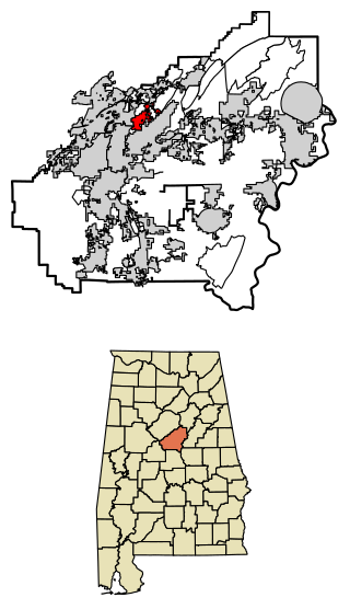
Ragland is a town in St. Clair County, Alabama, United States southeast of Ashville. It incorporated in 1899. At the 2020 census, the population was 1,693, up slightly from 1,639 in 2010. It is part of the Birmingham-Hoover-Cullman Combined Statistical Area.

<span class="mw-page-title-main">Advance, Indiana</span> Town in Indiana, United States

Advance is a town in Jackson Township, Boone County, Indiana, United States. The population was 503 at the 2020 census.

<span class="mw-page-title-main">Ulen, Indiana</span> Town in Indiana, United States

Ulen is a town in Center Township, Boone County, in the U.S. state of Indiana. The population was 117 at the 2010 census. The town is surrounded by the city of Lebanon.

<span class="mw-page-title-main">Converse, Indiana</span> Town in Indiana, United States

Converse is a town in Jackson Township, Miami County, and Richland Township, Grant County, in the U.S. state of Indiana. The population was 1,161 at the 2020 census.

<span class="mw-page-title-main">Coatesville, Indiana</span> Town in Indiana, United States

Coatesville is a town in Clay Township, Hendricks County, Indiana, United States. The population was 523 at the 2010 Census.

<span class="mw-page-title-main">Kennard, Indiana</span> Town in Indiana, United States

Kennard is a town in Greensboro Township, Henry County, Indiana, United States. The population was 471 at the 2010 census.

<span class="mw-page-title-main">Linden, Indiana</span> Town in Indiana, United States

Linden is a town in Madison Township, Montgomery County, in the U.S. state of Indiana. The population was 711 at the 2020 census.

<span class="mw-page-title-main">Anita, Iowa</span> City in Iowa, United States

Anita is a city in Cass County, Iowa, United States, platted in 1869 and incorporated in 1875. The population was 963 at the 2020 census. Lake Anita State Park is located just outside the town.

<span class="mw-page-title-main">Minden, Iowa</span> City in Iowa, United States

Minden is a city in Pottawattamie County, Iowa, United States. The population was 600 at the time of the 2020 census.

Bradford is a town in Penobscot County, Maine, United States. It is part of the Bangor, Maine Metropolitan Statistical Area. The population was 1,184 at the 2020 census.

<span class="mw-page-title-main">Hartland, Minnesota</span> City in Minnesota, United States

Hartland is a city in Freeborn County, Minnesota, United States. The population was 315 at the 2010 census.

<span class="mw-page-title-main">Pantego, North Carolina</span> Town in North Carolina, United States

Pantego is a town in Beaufort County, North Carolina, United States. The population was 179 at the 2010 Census.

<span class="mw-page-title-main">Colerain, North Carolina</span> Town in North Carolina, United States

Colerain is a town in Bertie County, North Carolina, United States. The population was 204 at the 2010 census.

<span class="mw-page-title-main">Thompson, North Dakota</span> City in North Dakota, United States

Thompson is a city in Grand Forks County, North Dakota, United States. It is part of the "Grand Forks, ND-MN Metropolitan Statistical Area" or "Greater Grand Forks". It is located on the border of Allendale and Walle townships, with Walle on the east and Allendale on the west. The population was 1,101 at the 2020 census. Thompson was founded in 1881.

<span class="mw-page-title-main">Newburg, West Virginia</span> Town in West Virginia, United States

Newburg is a town in western Preston County, West Virginia, United States. The population was 275 at the 2020 census. It is part of the Morgantown metropolitan area.

<span class="mw-page-title-main">Black Earth, Wisconsin</span> Village in Wisconsin, United States

Black Earth is a village in Dane County, Wisconsin, United States. The population was 1,338 at the 2010 census. The village is located within the Town of Black Earth. It is part of the Madison Metropolitan Statistical Area.

Oakfield is a town in Fond du Lac County, Wisconsin, United States. The population was 767 at the 2000 census. The Village of Oakfield is located within the town. The unincorporated community of Oak Center is also located in the town.

References

  1. "ArcGIS REST Services Directory". United States Census Bureau. Retrieved September 20, 2022.
  2. 1 2 U.S. Geological Survey Geographic Names Information System: Dortches, North Carolina
  3. 1 2 "U.S. Census website". United States Census Bureau . Retrieved January 31, 2008.
  4. "National Register Information System". National Register of Historic Places . National Park Service. July 9, 2010.
  5. "Census of Population and Housing". Census.gov. Retrieved June 4, 2015.