Kill Devil Hills, North Carolina

Last updated

Kill Devil Hills, North Carolina
542535192 1919308588 0.jpg
Kill Devil Hills beach guard tower, north of the Wright Memorial
Kill Devil Hills, NC Town Flag.gif
Seal of Kill Devil Hills.png
Nickname: 
Birthplace of Aviation
Dare County North Carolina incorporated and unincorporated areas Kill Devil Hills highlighted.svg
Location in Dare County and the U.S. state of North Carolina.
USA North Carolina location map.svg
Red pog.svg
Kill Devil Hills
Usa edcp location map.svg
Red pog.svg
Kill Devil Hills
Coordinates: 36°1′32″N75°40′12″W / 36.02556°N 75.67000°W / 36.02556; -75.67000
Country United States
State North Carolina
County Dare
Incorporated1953 [1]
Named for Unwholesome rum [1] [2]
Area
[3]
  Total5.66 sq mi (14.67 km2)
  Land5.61 sq mi (14.53 km2)
  Water0.06 sq mi (0.14 km2)
Elevation
7 ft (2 m)
Population
 (2020)
  Total7,656
  Density1,365.19/sq mi (527.08/km2)
Time zone UTC-5 (Eastern (EST))
  Summer (DST) UTC-4 (EDT)
ZIP code
27948
Area code 252
FIPS code 37-35720 [4]
GNIS feature ID1025849 [5]
Websitekdhnc.com

Kill Devil Hills is a town in Dare County, North Carolina, United States. The population was 7,633 at the 2020 census, [6] up from 6,683 in 2010. It is the most populous settlement in both Dare County and on the Outer Banks of North Carolina. The Kill Devil Hills Micropolitan Statistical Area is part of the larger Virginia Beach-Norfolk, VA-NC Combined Statistical Area.

Contents

The town was founded and developed on the site of the Wright brothers' first controlled, powered airplane flights on December 17, 1903, chosen for its good winds. [7] It was commemorated by the Wright Brothers National Memorial, which was dedicated in 1932. [8] At the time of the Wright Flyer flights, the town of Kill Devil Hills did not exist, and it did not receive its municipal charter until 1953. [9] Kitty Hawk, popularly noted as the site of the famous flights, is approximately four miles (6 km) to the north, and was the nearest settlement at the time of the famous flight.

History

Kill Devil Hills is the site of the Wright Brothers National Memorial, commemorating the siblings' four powered airplane flights in the Wright Flyer on Thursday, December 17, 1903. Orville returned in 1911, and on October 25 he set a new world glider record, remaining in the air 10 minutes and 34 seconds, soaring against the wind with very little forward movement. [10]

In addition to the Wright Brothers National Memorial, Sam's Diner in the town is on the National Register of Historic Places, listed in 1999. [11]

Geography

Kill Devil Hills is located at 36°1′32″N75°40′12″W / 36.02556°N 75.67000°W / 36.02556; -75.67000 (36.025448, −75.670105), [12] on the barrier islands known as the Outer Banks. [9]

According to the United States Census Bureau, the town has a total area of 5.5 square miles (14 km2), of which 5.5 square miles (14 km2) is land and 0.04 square miles (0.10 km2) (0.36%) is water.

As a result of its climate and proximity to beaches, the population rises significantly in Kill Devil Hills and other towns located on the Outer Banks during the summer months.

Demographics

Historical population
CensusPop.Note
1960 268
1970 35733.2%
1980 1,796403.1%
1990 4,238136.0%
2000 5,89739.1%
2010 6,68313.3%
2020 7,63314.2%
2021 (est.)7,777 [6] 1.9%
sources: [13] [14]

2020 census

Kill Devil Hills racial composition [15]
RaceNumberPercentage
White (non-Hispanic)6,47884.61%
Black or African American (non-Hispanic)861.12%
Native American 250.33%
Asian 841.1%
Other/Mixed 3244.23%
Hispanic or Latino 6598.61%

As of the 2020 United States census, there were 7,656 people, 3,170 households, and 1,809 families residing in the town.

2000 census

As of the census [4] of 2000, there were 5,897 people, 2,585 households, and 1,491 families residing in the town. The population density was 1,067.8 inhabitants per square mile (412.3/km2). There were 5,302 housing units at an average density of 960.1 per square mile (370.7/km2). The racial makeup of the town was 96.40% White, 0.61% African American, 0.17% Native American, 0.59% Asian, 0.12% Pacific Islander, 1.05% from other races, and 1.05% from two or more races. Hispanic or Latino of any race were 2.95% of the population. 26.4% had children under the age of 18 living with them, 44.2% were married couples living together, 9.6% had a female householder with no husband present, and 42.3% were non-families. 27.9% of all households were made up of individuals, and 6.5% had someone living alone who was 65 years of age or older. The average household size was 2.28 and the average family size was 2.77.

In the town, the population was spread out, with 20.9% under the age of 18, 7.5% from 18 to 24, 38.1% from 25 to 44, 22.8% from 45 to 64, and 10.7% who were 65 years of age or older. The median age was 37 years. For every 100 females, there were 105.0 males. For every 100 females age 18 and over, there were 106.3 males.

The median income for a household in the town was $39,713, and the median income for a family was $44,681. Males had a median income of $31,431 versus $23,206 for females. The per capita income for the town was $20,679. About 5.2% of families and 8.3% of the population were below the poverty line, including 7.8% of those under age 18 and 5.5% of those age 65 or over.

Kill Devil Hills is part of North Carolina's 3rd congressional district, represented by Republican Greg Murphy; who was elected in a special election to fill the seat vacated by the death of longtime Republican Congressman Walter B. Jones following Jones' death on February 10, 2019. [16]

Sports

Kill Devil Hills is home to the Outer Banks Daredevils of the Tidewater Summer League, a collegiate summer baseball league. The Daredevils play at First Flight Baseball Complex on Veterans Drive in Kill Devil Hills. The team, founded in 1997, began play in Kill Devil Hills in 2005. [17]

Transportation

In 1903 the Wright Brothers flew the first airplane, the Wright Flyer, from land now part of Kill Devil Hills Wright First Flight 1903Dec17 (full restore 115).jpg
In 1903 the Wright Brothers flew the first airplane, the Wright Flyer , from land now part of Kill Devil Hills

First Flight Airport ( IATA : FFA, ICAO : KFFA, FAA LID : FFA) is a public use airport which is owned by the National Park Service (NPS), and located one mile west of Kill Devil Hills. [18]

First Flight Airport covers an area of 40 acres at an elevation of 13 feet (4 metres) above mean sea level. It has one runway; designated 3/21, with an asphalt surface measuring 3,000 by 60 feet (914 by 18 metres). For the 12-month period ending August 19, 2009, the airport had 38,120 aircraft operations, an average of 104 per day: 97% general aviation, 3% air taxi, and <1% military. [18]

The airport is notable for being the site of hundreds of pre-flight gliding experiments carried out by the Wright brothers. The U.S. Centennial of Flight Commission chose First Flight Airport as one of the stops for the National Air Tour 2003. [19]

Education

It is within Dare County Schools.

First Flight Elementary School and First Flight Middle School are in Kill Devil Hills, just south of the Monument. Kill Devil Hills is also served by First Flight High School. The school first opened on Tuesday, August 17, 2004, to 800 students. Previously, high school students from Kill Devil Hills attended Manteo High School. [20]

Some portions of Kill Devil Hills are zoned to Nags Head Elementary instead of First Flight Elementary. [21] Previously Kitty Hawk Elementary School served areas north of Collington Road/Ocean Bay Bridge while First Flight Elementary served points south. [22] Boundaries changed when Nags Head Elementary opened in 2005. [23]

Dare County Library has a branch in Kill Devil Hills. [24]

Climate

According to the Trewartha climate classification system, Kill Devil Hills, North Carolina has a humid subtropical climate with hot and humid summers, cool winters and year-round precipitation (Cfak). Cfak climates are characterized by all months having an average mean temperature > 32.0 °F (> 0.0 °C), at least eight months with an average mean temperature ≥ 50.0 °F (≥ 10.0 °C), at least one month with an average mean temperature ≥ 71.6 °F (≥ 22.0 °C) and no significant precipitation difference between seasons. During the summer months in Kill Devil Hills, a cooling afternoon sea breeze is present on most days, but episodes of extreme heat and humidity can occur with heat index values ≥ 100 °F (≥ 38 °C). Kill Devil Hills is prone to hurricane strikes, particularly during the Atlantic hurricane season which extends from June 1 through November 30, sharply peaking from late August through September. During the winter months, episodes of cold and wind can occur with wind chill values < 10 °F (< -12 °C). The plant hardiness zone in Kill Devil Hills is 8b with an average annual extreme minimum air temperature of 17.0 °F (-8.3 °C). [25] The average seasonal (Dec-Mar) snowfall total is < 2 inches (< 5 cm), and the average annual peak in nor'easter activity is in February.

Climate data for Kill Devil Hills, NC (1981-2010 Averages)
MonthJanFebMarAprMayJunJulAugSepOctNovDecYear
Mean daily maximum °F (°C)50.8
(10.4)
52.6
(11.4)
58.1
(14.5)
66.5
(19.2)
73.9
(23.3)
81.5
(27.5)
85.4
(29.7)
84.2
(29.0)
79.5
(26.4)
71.2
(21.8)
63.0
(17.2)
54.6
(12.6)
68.5
(20.3)
Daily mean °F (°C)44.1
(6.7)
45.7
(7.6)
50.8
(10.4)
59.0
(15.0)
67.0
(19.4)
75.4
(24.1)
79.7
(26.5)
78.9
(26.1)
74.3
(23.5)
65.3
(18.5)
56.6
(13.7)
48.0
(8.9)
62.1
(16.7)
Mean daily minimum °F (°C)37.4
(3.0)
38.9
(3.8)
43.5
(6.4)
51.6
(10.9)
60.2
(15.7)
69.3
(20.7)
74.1
(23.4)
73.5
(23.1)
69.1
(20.6)
59.4
(15.2)
50.2
(10.1)
41.3
(5.2)
55.8
(13.2)
Average precipitation inches (mm)4.28
(109)
3.54
(90)
3.84
(98)
3.44
(87)
3.75
(95)
4.31
(109)
4.96
(126)
5.98
(152)
5.29
(134)
3.79
(96)
3.70
(94)
3.76
(96)
50.64
(1,286)
Average relative humidity (%)70.269.566.966.669.372.473.873.073.070.171.872.070.7
Average dew point °F (°C)35.0
(1.7)
36.3
(2.4)
40.2
(4.6)
47.9
(8.8)
56.6
(13.7)
65.9
(18.8)
70.6
(21.4)
69.5
(20.8)
65.1
(18.4)
55.3
(12.9)
47.6
(8.7)
39.4
(4.1)
52.5
(11.4)
Source: PRISM [26]


Climate data for Duck, NC Ocean Water Temperature (12 NW Kill Devil Hills)
MonthJanFebMarAprMayJunJulAugSepOctNovDecYear
Daily mean °F (°C)45
(7)
44
(7)
46
(8)
59
(15)
67
(19)
74
(23)
71
(22)
74
(23)
75
(24)
69
(21)
59
(15)
52
(11)
61
(16)
Source: NOAA [27]

Ecology

According to the A. W. Kuchler U.S. potential natural vegetation types, Kill Devil Hills, North Carolina would have a dominant vegetation type of Live oak/Sea Oats Uniola paniculata (90) with a dominant vegetation form of Coastal Prairie (20). [28]

Related Research Articles

<span class="mw-page-title-main">Kitty Hawk, North Carolina</span> Town in North Carolina, United States

Kitty Hawk is a town in Dare County, North Carolina, on Bodie Island, part of what is known as the state's Outer Banks. The population was 3,708 at the 2020 census. It was established in the early 18th century as Chickahawk.

<span class="mw-page-title-main">Dare County, North Carolina</span> County in North Carolina, United States

Dare County is the easternmost county in the U.S. state of North Carolina. As of the 2020 census, the population was 36,915. Its county seat is Manteo.

<span class="mw-page-title-main">Currituck County, North Carolina</span> County in North Carolina, United States

Currituck County is the northeasternmost county in the U.S. state of North Carolina. As of the 2020 census, the population was 28,100. Its county seat is Currituck. The county was formed in 1668 as a precinct of Albemarle County and later gained county status in 1739. The name is "traditionally said to be an indigenous word for wild geese; Coratank." Currituck County is included in the Virginia Beach-Chesapeake, VA-NC Combined Statistical Area. It is in the northeastern section of the state and is bounded by the Atlantic Ocean, Currituck Sound, Camden County, Dare County and the Commonwealth of Virginia. Currituck Court House, mentioned as early as 1755, was the name of the county seat. Today the words "Court House" have been dropped and only Currituck is used as the community name.

<span class="mw-page-title-main">Hailey, Idaho</span> City in and county seat of Blaine County, Idaho, United States

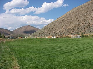
Hailey is a city in and the county seat of Blaine County, in the Wood River Valley of the central part of the U.S. state of Idaho. The population was 7,960 at the 2010 census, up from 6,200 in 2000. Hailey is the site of Friedman Memorial Airport (SUN), the airport for the resort area of Sun Valley/Ketchum, 12 miles (19 km) north. The town of Bellevue is a few miles south. From 1882 to 1895, Hailey was the county seat of now-defunct Alturas County.

<span class="mw-page-title-main">Manteo, North Carolina</span> Town in North Carolina, United States

Manteo is a town in Dare County, North Carolina, United States, located on Roanoke Island. The population was 1,602 at the 2020 census. It is the county seat of Dare County.

<span class="mw-page-title-main">Nags Head, North Carolina</span> Town in North Carolina, United States

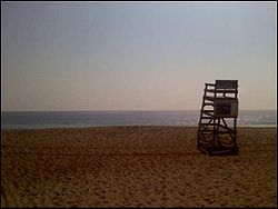
Nags Head is a town in Dare County, North Carolina, United States. It is a busy vacation spot because of its beaches and sand dunes of Jockey's Ridge. The population was 3,146 at the 2020 census.

<span class="mw-page-title-main">Southern Shores, North Carolina</span> Town in North Carolina, United States

Southern Shores is a town in Dare County, North Carolina, United States. It is located on the Outer Banks and the population was 3,107 at the 2020 census.

<span class="mw-page-title-main">Walterboro, South Carolina</span> City in South Carolina, United States

Walterboro is a city in Colleton County, South Carolina, United States. The city's population was 5,398 at the 2010 census. It is the county seat of Colleton County. Walterboro is located 48 miles (77 km) west of Charleston and is located near the ACE Basin region in the South Carolina Lowcountry.

<span class="mw-page-title-main">Duck, North Carolina</span> Town in North Carolina, United States

Duck is a town in Dare County, North Carolina, United States. As of the 2020 census, the population was 746. During the peak vacation season, starting after Memorial Day, the population increases to over 20,000. Duck is the northernmost incorporated town in Dare County and the Outer Banks' newest town, incorporated on May 1, 2002. Duck offers visitors outdoor recreational activities, summer events and concerts, watersports, fine dining, shopping, art galleries, and a nationally known jazz festival, as well as the 11-acre (4.5 ha) Town Park and soundside boardwalk.

<span class="mw-page-title-main">Rodanthe, North Carolina</span> Census-designated place in North Carolina, United States

Rodanthe is an unincorporated community and census-designated place (CDP) located in Dare County, North Carolina, United States, on Hatteras Island, part of North Carolina's Outer Banks. As of the 2020 census it had a population of 213. Rodanthe, along with Waves and Salvo, are part of the settlement of Chicamacomico. Rodanthe includes the original Chicamacomico Life-Saving Station, decommissioned in 1954, but now a museum.

<span class="mw-page-title-main">Salvo, North Carolina</span> Census-designated place in North Carolina, United States

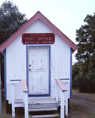
Salvo is a census-designated place located in Dare County, North Carolina, United States, on Hatteras Island, part of North Carolina's Outer Banks. As of the 2010 census, Salvo had a population of 229. Originally part of the settlement of Chicamacomico, Salvo was originally known as "Clarks" or "Clarksville."

<span class="mw-page-title-main">Buxton, North Carolina</span> Census-designated place in North Carolina, United States of America

Buxton is an unincorporated community and census-designated place (CDP) on Hatteras Island near Cape Hatteras. It is located in Dare County in the U.S. state of North Carolina. As of the 2010 census, it had a population of 1,273. Located at the widest part of Hatteras Island, it is the largest community on Hatteras Island both in terms of area and population, and is home to the island's schools and other major public buildings and offices.

<span class="mw-page-title-main">Frisco, North Carolina</span> Census-designated place in North Carolina, United States of America

Frisco is a small unincorporated community and census-designated place (CDP) on the barrier island of Hatteras Island, between the villages of Buxton and Hatteras. It is located in Dare County, North Carolina, United States, and was previously named "Trent", or "Trent Woods", but received a new name with the coming of the post office in 1898. Most of the land is taken by houses available for rental during the summer months, and as such the community's population varies seasonally. As of the 2010 census, the permanent population of the community was 200. North Carolina Highway 12 serves as the primary road in Frisco and connects the community to others on the island.

<span class="mw-page-title-main">Colington Island</span> Island in North Carolina, United States

Colington Island is an island located to the west of Kill Devil Hills in Dare County, North Carolina, United States. The island is located at the converging point of Albemarle Sound, Currituck Sound, Croatan Sound, and Roanoke Sound. While it is commonly referred to as one island, there are actually two separate islands, Big Colington Island and Little Colington Island. Colington Harbour is a gated community located on Big Colington Island.

<span class="mw-page-title-main">Wright Brothers National Memorial</span> Monument marking the location of the first airplane flight

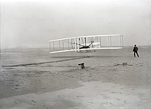
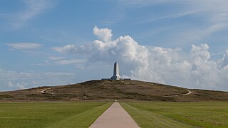
Wright Brothers National Memorial, located in Kill Devil Hills, North Carolina, commemorates the first successful, sustained, powered flights in a heavier-than-air machine. From 1900 to 1903, Wilbur and Orville Wright came here from Dayton, Ohio, based on information from the U.S. Weather Bureau about the area's steady winds. They also valued the privacy provided by this location, which in the early twentieth century was remote from major population centers.

<span class="mw-page-title-main">Outer Banks</span> Barrier islands in North Carolina, United States

The Outer Banks are a 200 mi (320 km) string of barrier islands and spits off the coast of North Carolina and southeastern Virginia, on the east coast of the United States. They line most of the North Carolina coastline, separating Currituck Sound, Albemarle Sound, and Pamlico Sound from the Atlantic Ocean. A major tourist destination, the Outer Banks are known for their wide expanse of open beachfront and the Cape Hatteras National Seashore. The seashore and surrounding ecosystem are important biodiversity zones, including beach grasses and shrubland that help maintain the form of the land.

<span class="mw-page-title-main">First Flight Airport</span> Public use airport in North Carolina, U.S.

First Flight Airport is a public use airport located one nautical mile west of the central business district of Kill Devil Hills, a town in Dare County, North Carolina, United States. The airport is owned by the U.S. National Park Service. It is included in the National Plan of Integrated Airport Systems for 2011–2015, which categorized it as a general aviation facility.

<span class="mw-page-title-main">Dare County Schools</span>

Dare County Schools (DCS) is a school district for Dare County, North Carolina. Its headquarters are in Nags Head.

<span class="mw-page-title-main">The Outer Banks Hospital</span> Hospital in North Carolina, United States

The Outer Banks Hospital (OBH) is a critical access hospital located in Nags Head, Dare County on the Outer Banks. It is 60%/40% partnership of the ECU Health and Chesapeake Regional Healthcare (CRH). The hospital opened in March 2002. The hospital has 21 general hospital beds. It also includes three Shared Inpatient/Ambulatory Surgery, one Endoscopy, and one C-Section operating rooms.

<span class="mw-page-title-main">First Flight High School</span> Public school in Kill Devil Hills, North Carolina, United States

First Flight High School is a public high school serving grades 9–12. The school was established in 2004, and is located in Kill Devil Hills, North Carolina on the Outer Banks of North Carolina.

References

  1. 1 2 "North Carolina Gazetteer" . Retrieved March 27, 2021.
  2. Ryan (February 5, 2016). "Outer Banks Town Names - Where did they come from?" . Retrieved March 27, 2021.
  3. "ArcGIS REST Services Directory". United States Census Bureau. Retrieved September 20, 2022.
  4. 1 2 "U.S. Census website". United States Census Bureau . Retrieved January 31, 2008.
  5. "US Board on Geographic Names". United States Geological Survey. October 25, 2007. Retrieved January 31, 2008.
  6. 1 2 "City and Town Population Totals: 2020-2021". Census.gov. US Census Bureau. Retrieved July 9, 2022.
  7. "Telegram from Orville Wright in Kitty Hawk, North Carolina, to His Father Announcing Four Successful Flights, December 17, 1903". World Digital Library . December 17, 1903. Retrieved July 21, 2013.
  8. "Wright Brothers National Memorial (U.S. National Park Service)".
  9. 1 2 "Kill Devil Hills". Outer Banks Visitors Bureau. Retrieved April 5, 2013.
  10. "Flying Machine: Construction and Operation – Chapter XXVII". Worldwideschool.org. July 1, 1911. Archived from the original on February 5, 2000. Retrieved October 25, 2009.
  11. "National Register Information System  Sam's Diner (#99000062)". National Register of Historic Places . National Park Service. November 2, 2013. Retrieved July 7, 2018.
  12. "US Gazetteer files: 2010, 2000, and 1990". United States Census Bureau. February 12, 2011. Retrieved April 23, 2011.
  13. "Census of Population and Housing". U.S. Census Bureau. Retrieved April 5, 2013.
  14. "Census of Population and Housing". Census.gov. Retrieved June 4, 2016.
  15. "Explore Census Data". data.census.gov. Retrieved December 21, 2021.
  16. Seelye, Katherine (February 13, 2019). "Walter B. Jones, 76, Dies; Republican Turned Against Iraq War". New York Times . Retrieved April 9, 2019.
  17. "Daredevils History…". OBX Daredevils - A Collegiate Summer Baseball Team. Retrieved April 11, 2019.
  18. 1 2 FAA Airport Form 5010 for FFA PDF . Federal Aviation Administration. Effective May 31, 2012.
  19. "The National Park Service and the National Air Tour 2003 Announce Plans for Stop at Wright Brothers National Memorial". www.CentennialOfFlight.gov. U.S. Centennial of Flight Commission. 2003. Archived from the original on September 23, 2006. Retrieved December 19, 2006.
  20. Freeman, Darren (August 18, 2004). "NO LINES, NO CROWDS, JUST MORE SPACE". The Virginian-Pilot. Archived from the original on September 11, 2004. Retrieved October 25, 2009. - Entry at NewsBank
  21. "Attendance Zone Information". Dare County Schools . Retrieved April 12, 2021. Nags Head Elementary School -- All of the Town of Nags Head and the following areas in Kill Devil Hills: from Cameron Street south to Ocean Bay Boulevard and from Airstrip Road/Calvin Street south to 8th street
  22. "Attendance Zones". Dare County Schools. February 19, 2002. Archived from the original on December 19, 2003. Retrieved April 14, 2021.{{cite web}}: CS1 maint: bot: original URL status unknown (link)-
  23. Freeman, Darren (October 3, 2004). "Boundary lines for Nags Head Elementary set for next year". The Virginian-Pilot . Archived from the original on October 15, 2004. Retrieved April 14, 2021.
  24. "Home". Dare County Library. Retrieved April 13, 2021.
  25. "USDA Interactive Plant Hardiness Map". United States Department of Agriculture. Archived from the original on July 4, 2019. Retrieved August 6, 2019.
  26. "PRISM Climate Group, Oregon State University" . Retrieved August 6, 2019.
  27. "Water Temperature Table of All Coastal Regions" . Retrieved August 6, 2019.
  28. "U.S. Potential Natural Vegetation, Original Kuchler Types, v2.0 (Spatially Adjusted to Correct Geometric Distortions)" . Retrieved August 6, 2019.
  29. Metal Talk (March 5, 2011). "REX BROWN AND VINNIE APPICE FORM NEW BAND - KILL DEVIL HILL". Metal Talk. Retrieved October 11, 2017.
  30. Brainstorm (1983) - IMDb , retrieved June 21, 2021
  31. "Dennis Anderson". MonsterJam.com. Archived from the original on March 7, 2012. Retrieved February 10, 2012.


Preceded by Beaches of The Outer Banks Succeeded by