Southern Shores, North Carolina

Last updated

Southern Shores, North Carolina
Southern Shores, NC Town Flag.gif
Southern Shores, NC Town Seal.png
Dare County North Carolina incorporated and unincorporated areas Southern Shores highlighted.svg
Location in Dare County and the state of North Carolina
Coordinates: 36°7′28″N75°43′57″W / 36.12444°N 75.73250°W / 36.12444; -75.73250
Country United States
State North Carolina
County Dare
Incorporated1969 [1]
Area
[2]
  Total4.15 sq mi (10.75 km2)
  Land3.95 sq mi (10.22 km2)
  Water0.20 sq mi (0.53 km2)
Elevation
[3]
20 ft (6 m)
Population
 (2020)
  Total3,090
  Density783.07/sq mi (302.33/km2)
Time zone UTC-5 (Eastern (EST))
  Summer (DST) UTC-4 (EDT)
ZIP code
27949
Area code 252
FIPS code 37-63130 [4]
GNIS feature ID1001094 [3]
Website southernshores-nc.gov

Southern Shores is a town in Dare County, North Carolina, United States. It is located on the Outer Banks [5] and the population was 3,107 at the 2020 census. [6]

Contents

Geography

Southern Shores is located at 36°7′28″N75°43′57″W / 36.12444°N 75.73250°W / 36.12444; -75.73250 (36.124454, -75.732612). [7]

According to the United States Census Bureau, the town has a total area of 4.2 square miles (10.8 km2), of which 3.9 square miles (10.2 km2) is land and 0.19 square miles (0.5 km2), or 4.92%, is water. [8]

Demographics

Historical population
CensusPop.Note
1980 395
1990 61756.2%
2000 2,201256.7%
2010 2,71423.3%
2020 3,10714.5%
2021 (est.)3,175 [6] 2.2%
U.S. Decennial Census [9]

2020 census

Southern Shores racial composition [10]
RaceNumberPercentage
White (non-Hispanic)2,87092.88%
Black or African American (non-Hispanic)150.49%
Native American 70.23%
Asian 220.71%
Pacific Islander 10.03%
Other/Mixed 1123.62%
Hispanic or Latino 632.04%

As of the 2020 United States census, there were 3,090 people, 1,225 households, and 915 families residing in the town.

2000 census

As of the census [4] of 2000, there were 2,201 people, 946 households, and 725 families residing in the town. The population density was 540.4 inhabitants per square mile (208.6/km2). There were 1,921 housing units at an average density of 471.7 per square mile (182.1/km2). The racial makeup of the town was 98.23% White, 0.09% African American, 0.23% Native American, 0.23% Asian, 0.09% Pacific Islander, 0.64% from other races, and 0.50% from two or more races. Hispanic or Latino of any race were 1.54% of the population.

There were 946 households, out of which 21.8% had children under the age of 18 living with them, 71.6% were married couples living together, 3.7% had a female householder with no husband present, and 23.3% were non-families. 20.2% of all households were made up of individuals, and 9.5% had someone living alone who was 65 years of age or older. The average household size was 2.33 and the average family size was 2.64.

In the town, the population was spread out, with 18.6% under the age of 18, 2.7% from 18 to 24, 17.4% from 25 to 44, 36.5% from 45 to 64, and 24.9% who were 65 years of age or older. The median age was 51 years. For every 100 females, there were 97.4 males. For every 100 females age 18 and over, there were 93.2 males.

The median income for a household in the town was $61,676, and the median income for a family was $68,250. Males had a median income of $41,563 versus $31,875 for females. The per capita income for the town was $35,933. About 1.6% of families and 3.1% of the population were below the poverty line, including 4.6% of those under age 18 and 0.8% of those age 65 or over.

Climate

According to the Trewartha climate classification system, Southern Shores, North Carolina has a humid subtropical climate with hot and humid summers, cool winters and year-around precipitation (Cfak). Cfak climates are characterized by all months having an average mean temperature > 32.0 °F (> 0.0 °C), at least eight months with an average mean temperature ≥ 50.0 °F (≥ 10.0 °C), at least one month with an average mean temperature ≥ 71.6 °F (≥ 22.0 °C) and no significant precipitation difference between seasons. During the summer months in Southern Shores, a cooling afternoon sea breeze is present on most days, but episodes of extreme heat and humidity can occur with heat index values ≥ 100 °F (≥ 38 °C). Southern Shores is prone to hurricane strikes, particularly during the Atlantic hurricane season which extends from June 1 through November 30, sharply peaking from late August through September. During the winter months, episodes of cold and wind can occur with wind chill values < 10 °F (< -12 °C). The plant hardiness zone in Southern Shores is 8b with an average annual extreme minimum air temperature of 16.3 °F (-8.7 °C). [11] The average seasonal (Dec-Mar) snowfall total is < 2 inches (< 5 cm), and the average annual peak in nor'easter activity is in February.

Climate data for Southern Shores, NC (1981-2010 Averages)
MonthJanFebMarAprMayJunJulAugSepOctNovDecYear
Mean daily maximum °F (°C)49.1
(9.5)
51.1
(10.6)
56.5
(13.6)
64.6
(18.1)
72.1
(22.3)
79.4
(26.3)
83.4
(28.6)
81.8
(27.7)
77.2
(25.1)
69.4
(20.8)
61.3
(16.3)
53.0
(11.7)
66.6
(19.2)
Daily mean °F (°C)43.0
(6.1)
44.8
(7.1)
49.7
(9.8)
58.0
(14.4)
66.0
(18.9)
74.4
(23.6)
78.7
(25.9)
77.9
(25.5)
73.3
(22.9)
64.5
(18.1)
55.8
(13.2)
46.9
(8.3)
61.2
(16.2)
Mean daily minimum °F (°C)37.0
(2.8)
38.4
(3.6)
43.0
(6.1)
51.3
(10.7)
59.9
(15.5)
69.4
(20.8)
74.1
(23.4)
73.9
(23.3)
69.4
(20.8)
59.6
(15.3)
50.2
(10.1)
40.9
(4.9)
55.7
(13.2)
Average precipitation inches (mm)4.16
(106)
3.47
(88)
3.86
(98)
3.38
(86)
3.71
(94)
4.27
(108)
4.98
(126)
5.88
(149)
5.21
(132)
3.79
(96)
3.64
(92)
3.67
(93)
50.02
(1,271)
Average relative humidity (%)70.069.467.668.070.775.176.875.473.771.872.571.971.9
Average dew point °F (°C)33.9
(1.1)
35.4
(1.9)
39.4
(4.1)
47.5
(8.6)
56.2
(13.4)
66.0
(18.9)
70.8
(21.6)
69.5
(20.8)
64.4
(18.0)
55.2
(12.9)
47.1
(8.4)
38.3
(3.5)
52.1
(11.2)
Source: PRISM [12]


Climate data for Duck, NC Ocean Water Temperature (4 N Southern Shores)
MonthJanFebMarAprMayJunJulAugSepOctNovDecYear
Daily mean °F (°C)45
(7)
44
(7)
46
(8)
59
(15)
67
(19)
74
(23)
71
(22)
74
(23)
75
(24)
69
(21)
59
(15)
52
(11)
61
(16)
Source: NOAA [13]

Ecology

According to the A. W. Kuchler U.S. potential natural vegetation types, Southern Shores, North Carolina would have a dominant vegetation type of Live oak/Sea Oats Uniola paniculata (90) with a dominant vegetation form of Coastal Prairie (20). [14]

Education

Residents are zoned to Dare County Schools. Zoned schools are Kitty Hawk Elementary School, First Flight Middle School, and First Flight High School. [15] Prior to 2004, First Flight High zoned students were zoned to Manteo High School. [16]

Related Research Articles

<span class="mw-page-title-main">Kitty Hawk, North Carolina</span> Town in North Carolina, United States

Kitty Hawk is a town in Dare County, North Carolina, on Bodie Island, part of what is known as the state's Outer Banks. The population was 3,708 at the 2020 census. It was established in the early 18th century as Chickahawk.

<span class="mw-page-title-main">Dover Beaches North, New Jersey</span> Populated place in Ocean County, New Jersey, US

Dover Beaches North is an unincorporated community and census-designated place (CDP) located within Toms River, in Ocean County, in the U.S. state of New Jersey. As of the 2010 United States Census, the CDP's population was 1,239. The CDP includes the communities of Ocean Beaches 1, 2 and 3, Chadwick Beach, Chadwick Island, Seacrest Beach, Monterey Beach, Silver Beach, Normandy Shores and half of Normandy Beach. Dover Beaches North is situated on the Barnegat Peninsula, a long, narrow barrier peninsula that separates Barnegat Bay from the Atlantic Ocean.

<span class="mw-page-title-main">Dover Beaches South, New Jersey</span> Populated place in Ocean County, New Jersey, US

Dover Beaches South, more commonly known as Ortley Beach, is an unincorporated community and census-designated place (CDP) located within Toms River, in Ocean County, in the U.S. state of New Jersey. As of the 2010 United States Census, the CDP's population was 1,209. Dover Beaches South is situated on the Barnegat Peninsula, a long, narrow barrier peninsula that separates Barnegat Bay from the Atlantic Ocean.

<span class="mw-page-title-main">North Beach Haven, New Jersey</span> Populated place in Ocean County, New Jersey, US

North Beach Haven is an unincorporated community and census-designated place (CDP) constituting a part of the Jersey Shore community of Long Beach Township, in southern Ocean County, in the U.S. state of New Jersey. The CDP is situated on Long Beach Island, a barrier island separating Barnegat Bay from the Atlantic Ocean.

<span class="mw-page-title-main">Graham, North Carolina</span> City in North Carolina, United States

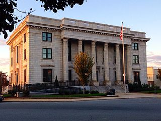
Graham is a city in Alamance County, North Carolina, United States. It is part of the Burlington, North Carolina Metropolitan Statistical Area. As of the 2020 census the population was 17,153. It is the county seat of Alamance County.

<span class="mw-page-title-main">Kill Devil Hills, North Carolina</span> Town in North Carolina, United States

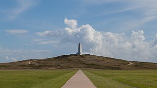
Kill Devil Hills is a town in Dare County, North Carolina, United States. The population was 7,633 at the 2020 census, up from 6,683 in 2010. It is the most populous settlement in both Dare County and on the Outer Banks of North Carolina. The Kill Devil Hills Micropolitan Statistical Area is part of the larger Virginia Beach-Norfolk, VA-NC Combined Statistical Area.

<span class="mw-page-title-main">Nags Head, North Carolina</span> Town in North Carolina, United States

Nags Head is a town in Dare County, North Carolina, United States. It is a busy vacation spot because of its beaches and sand dunes of Jockey's Ridge. The population was 3,146 at the 2020 census.

<span class="mw-page-title-main">Clayton, North Carolina</span> Town in North Carolina, United States

Clayton is a town in Johnston County, North Carolina, United States, and is considered a satellite town of Raleigh. As of 2010, Clayton's population was 16,116, up from 6,973 at the 2000 census. By 2019 the town's estimated population was 24,887. Much of that growth can be attributed to the town's proximity to the Research Triangle area and access to major highways such as I-40 and US 70.

<span class="mw-page-title-main">Moravian Falls, North Carolina</span> CDP in North Carolina, United States

Moravian Falls is a census-designated place (CDP) in Wilkes County, North Carolina, United States. The population was 1,712 as of the 2020 census.

<span class="mw-page-title-main">Chestnuthill Township, Pennsylvania</span> Place in Pennsylvania, United States

Chestnuthill Township is a township in Monroe County, Pennsylvania, United States. The population was 16,708 at the 2020 census.

<span class="mw-page-title-main">Eldred Township, Monroe County, Pennsylvania</span> Township in Pennsylvania, United States

Eldred Township is a township in Monroe County, Pennsylvania, United States. The population was 2,594 at the 2020 census.

<span class="mw-page-title-main">Price Township, Pennsylvania</span> Place in Pennsylvania, United States

Price Township is a township in Monroe County, Pennsylvania, United States. The population was 3,675 at the 2020 census.

<span class="mw-page-title-main">Kline, South Carolina</span> Town in South Carolina, United States

Kline is a town in Barnwell County, South Carolina, United States. The population was 197 at the 2010 census.

<span class="mw-page-title-main">Quinby, South Carolina</span> Town in South Carolina, United States

Quinby is a town in Florence County, South Carolina, United States. The population was 932 at the 2010 census, up from 842 in 2000. It is part of the Florence Metropolitan Statistical Area.

<span class="mw-page-title-main">Lake Wylie, South Carolina</span> CDP in South Carolina, United States

Lake Wylie is a census-designated place (CDP) in York County, South Carolina, United States. The population was 8,841 at the 2010 census. Lake Wylie is located on a peninsula along the shore of Lake Wylie, a reservoir that was named for Dr. W. Gil Wylie in 1960. It is a suburb of Charlotte, North Carolina.

<span class="mw-page-title-main">Avon, North Carolina</span> Census-designated place in North Carolina, United States

Avon is an unincorporated community and census-designated place (CDP) in Dare County in the U.S. state of North Carolina. As of the 2010 census, it had a permanent population of 776.

<span class="mw-page-title-main">Rodanthe, North Carolina</span> Census-designated place in North Carolina, United States

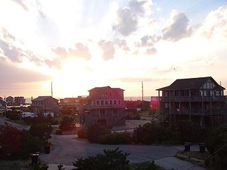
Rodanthe is an unincorporated community and census-designated place (CDP) located in Dare County, North Carolina, United States, on Hatteras Island, part of North Carolina's Outer Banks. As of the 2020 census it had a population of 213. Rodanthe, along with Waves and Salvo, are part of the settlement of Chicamacomico. Rodanthe includes the original Chicamacomico Life-Saving Station, decommissioned in 1954, but now a museum.

<span class="mw-page-title-main">Waves, North Carolina</span> Census-designated place in North Carolina, United States

Waves is an unincorporated community and census-designated place (CDP) in Dare County, North Carolina, United States. It is on Hatteras Island, part of North Carolina's Outer Banks. As of the 2010 census it had a population of 134. Waves, along with Rodanthe and Salvo, are part of the settlement of Chicamacomico.

<span class="mw-page-title-main">Buxton, North Carolina</span> Census-designated place in North Carolina, United States of America

Buxton is an unincorporated community and census-designated place (CDP) on Hatteras Island near Cape Hatteras. It is located in Dare County in the U.S. state of North Carolina. As of the 2010 census, it had a population of 1,273. Located at the widest part of Hatteras Island, it is the largest community on Hatteras Island both in terms of area and population, and is home to the island's schools and other major public buildings and offices.

<span class="mw-page-title-main">Frisco, North Carolina</span> Census-designated place in North Carolina, United States of America

Frisco is a small unincorporated community and census-designated place (CDP) on the barrier island of Hatteras Island, between the villages of Buxton and Hatteras. It is located in Dare County, North Carolina, United States, and was previously named "Trent", or "Trent Woods", but received a new name with the coming of the post office in 1898. Most of the land is taken by houses available for rental during the summer months, and as such the community's population varies seasonally. As of the 2010 census, the permanent population of the community was 200. North Carolina Highway 12 serves as the primary road in Frisco and connects the community to others on the island.

References

  1. "North Carolina Gazetteer" . Retrieved March 27, 2021.
  2. "ArcGIS REST Services Directory". United States Census Bureau. Retrieved September 20, 2022.
  3. 1 2 U.S. Geological Survey Geographic Names Information System: Southern Shores, North Carolina
  4. 1 2 "U.S. Census website". United States Census Bureau . Retrieved January 31, 2008.
  5. "Southern Shores". Outer Banks Visitors Bureau. Retrieved April 5, 2013.
  6. 1 2 Bureau, US Census. "City and Town Population Totals: 2020-2021". Census.gov. US Census Bureau. Retrieved July 9, 2022.
  7. "US Gazetteer files: 2010, 2000, and 1990". United States Census Bureau. February 12, 2011. Retrieved April 23, 2011.
  8. "Geographic Identifiers: 2010 Demographic Profile Data (G001): Southern Shores town, North Carolina". U.S. Census Bureau, American Factfinder. Archived from the original on February 13, 2020. Retrieved November 20, 2015.
  9. "Census of Population and Housing". Census.gov. Retrieved June 4, 2016.
  10. "Explore Census Data". data.census.gov. Retrieved December 21, 2021.
  11. "USDA Interactive Plant Hardiness Map". United States Department of Agriculture . Retrieved August 6, 2019.
  12. "PRISM Climate Group, Oregon State University" . Retrieved August 6, 2019.
  13. "Water Temperature Table of All Coastal Regions" . Retrieved August 6, 2019.
  14. "U.S. Potential Natural Vegetation, Original Kuchler Types, v2.0 (Spatially Adjusted to Correct Geometric Distortions)" . Retrieved August 6, 2019.
  15. "Attendance Zone Information". Dare County Schools . Retrieved April 12, 2021. Kitty Hawk Elementary School -- Area north of Cameron Street[...]First Flight Middle School/First Flight High School -- All areas north of Nags Head/Kill Devil Hills Town Line - North Beaches Elementary Schools map
  16. Freeman, Darren (August 18, 2004). "NO LINES, NO CROWDS, JUST MORE SPACE". The Virginian-Pilot. Archived from the original on September 11, 2004. Retrieved October 25, 2009. - Entry at NewsBank
Preceded by Beaches of The Outer Banks Succeeded by