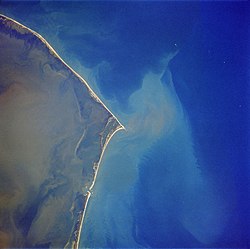
Shelly Island

Last updated

NASA Photos of Shelly Island, NC New-island-cape-point-nc-nasa.jpg
NASA Photos of Shelly Island, NC
1989 photo of Cape Hatteras, with Cape Point at center. Shelly Island formed just off the tip of Cape Point Cape hatteras 1989.jpg
1989 photo of Cape Hatteras, with Cape Point at center. Shelly Island formed just off the tip of Cape Point

Shelly Island was a sandy island which began forming around April 2017, as a sandbank in the Outer Banks of North Carolina. Located off the tip of Cape Point in Buxton, North Carolina, the island was greatly reduced by the passage of Hurricane Maria in late September 2017. At its greatest extent, the crescent-shaped island measured around one mile long and more than 500 ft (150 m) wide. It was nicknamed Shelly Island by locals because of the vast quantities of shells that were found on the shore. By early 2018, the island had disappeared.

Contents

Geography

The island sat a few hundred feet away from Hatteras Island, with water at depth of no more than 5 ft (1.5 m). [1] The surrounding area is referred to as the Graveyard of the Atlantic. [2] [3] Small landmasses frequently appear and vanish in this area, but Shelly Island was notable for its size and the speed with which it formed. [4] One explanation for the island's formation was a lack of strong nor'easter storms the previous winter, along with more than typical southwesterly winds, which led to the buildup of additional sand in the area. [5]

As long as the island remained detached, it fell under the jurisdiction of Dare County, North Carolina. If it had grown enough to merge into Hatteras Island, it would potentially have come under federal jurisdiction and become part of Cape Hatteras National Seashore. [1] In September 2017, businessman Ken Barlow filed a quitclaim deed against the island, seeking ownership of the land. [6] At that time, experts cautioned that the island would likely not last a full year as a separate landform. [4]

As of September 18, 2017, Shelly Island was connected to land at low tide, with water continuing to separate the island from the mainland at high tide. [7] Over the next few weeks, the channel between the island and the mainland began to deepen again. [6]

In late September 2017, after the passage of Hurricane Maria, North Carolina estimated that the island had been reduced by 70%, with the portion closest to the mainland reattaching, and a small oval of land remaining unattached offshore. [6]

Photographs from Landsat 8 taken on February 16, 2018 revealed that the island had completely disappeared and that what remained of the island had merged with Cape Point, North Carolina. [8]

Ownership claim

Ken Barlow, a businessman and resident of Mechanicsville, Virginia, alleged that he was the rightful owner of the island by way of a quitclaim deed he executed in the Dare County Register of Deeds office on August 7, 2017. [9] Barlow reasserted his claim in early 2018 despite the apparent disappearance of the island. [10]

Related Research Articles

<span class="mw-page-title-main">Roanoke Island</span> Island in the Outer Banks of North Carolina, United States

Roanoke Island is an island in Dare County, bordered by the Outer Banks of North Carolina. It was named after the historical Roanoke, a Carolina Algonquian people who inhabited the area in the 16th century at the time of English colonization.

<span class="mw-page-title-main">Dare County, North Carolina</span> County in North Carolina, United States

Dare County is the easternmost county in the U.S. state of North Carolina. As of the 2020 census, the population was 36,915. Its county seat is Manteo.

<span class="mw-page-title-main">Ocracoke, North Carolina</span> Census-designated place in North Carolina, United States

Ocracoke is a census-designated place (CDP) and unincorporated town located at the southern end of Ocracoke Island, located entirely within Hyde County, North Carolina, United States. The population was 948 as of the 2010 census. In the 2020 census, the population had dropped to 797 people.

<span class="mw-page-title-main">Cape Hatteras</span> Cape on the shoreline of Hatteras Island, North Carolina, United States

Cape Hatteras is a cape located at a pronounced bend in Hatteras Island, one of the barrier islands of North Carolina.

<span class="mw-page-title-main">Rodanthe, North Carolina</span> Census-designated place in North Carolina, United States

Rodanthe is an unincorporated community and census-designated place (CDP) located in Dare County, North Carolina, United States, on Hatteras Island, part of North Carolina's Outer Banks. As of the 2020 census it had a population of 213. Rodanthe, along with Waves and Salvo, are part of the settlement of Chicamacomico. Rodanthe includes the original Chicamacomico Life-Saving Station, decommissioned in 1954, but now a museum.

<span class="mw-page-title-main">Hatteras Island</span> Island in North Carolina, US

Hatteras Island is a barrier island located off the North Carolina coast. Dividing the Atlantic Ocean and the Pamlico Sound, it runs parallel to the coast, forming a bend at Cape Hatteras. It is part of North Carolina's Outer Banks and includes the communities of Rodanthe, Waves, Salvo, Avon, Buxton, Frisco, and Hatteras. It contains the largest part of the Cape Hatteras National Seashore. Prior to European settlement the island was inhabited by Croatoan Native Americans.

<span class="mw-page-title-main">Hatteras, North Carolina</span> Census-designated place in North Carolina, United States of America

Hatteras is an unincorporated village and census-designated place (CDP) in Dare County, North Carolina, United States, on the Outer Banks island of Hatteras, at its extreme southwestern tip. As of the 2010 census it had a population of 504. Immediately to the west of the village of Hatteras is Hatteras Inlet which separates Hatteras Island from the neighboring Ocracoke Island. North Carolina Highway 12 passes through the community linking it to Frisco to the east and Ocracoke to the west.

<span class="mw-page-title-main">Buxton, North Carolina</span> Census-designated place in North Carolina, United States of America

Buxton is an unincorporated community and census-designated place (CDP) on Hatteras Island near Cape Hatteras. It is located in Dare County in the U.S. state of North Carolina. As of the 2010 census, it had a population of 1,273. Located at the widest part of Hatteras Island, it is the largest community on Hatteras Island both in terms of area and population, and is home to the island's schools and other major public buildings and offices.

<span class="mw-page-title-main">Frisco, North Carolina</span> Census-designated place in North Carolina, United States of America

Frisco is a small unincorporated community and census-designated place (CDP) on the barrier island of Hatteras Island, between the villages of Buxton and Hatteras. It is located in Dare County, North Carolina, United States, and was previously named "Trent", or "Trent Woods", but received a new name with the coming of the post office in 1898. Most of the land is taken by houses available for rental during the summer months, and as such the community's population varies seasonally. As of the 2010 census, the permanent population of the community was 200. North Carolina Highway 12 serves as the primary road in Frisco and connects the community to others on the island.

<span class="mw-page-title-main">Outer Banks</span> Barrier islands in North Carolina, U.S.

The Outer Banks are a 200 mi (320 km) string of barrier islands and spits off the coast of North Carolina and southeastern Virginia, on the east coast of the United States. They line most of the North Carolina coastline, separating Currituck Sound, Albemarle Sound, and Pamlico Sound from the Atlantic Ocean. A major tourist destination, the Outer Banks are known for their wide expanse of open beachfront and the Cape Hatteras National Seashore. The seashore and surrounding ecosystem are important biodiversity zones, including beach grasses and shrubland that help maintain the form of the land.

<span class="mw-page-title-main">Hurricane Emily (1993)</span> Atlantic hurricane in 1993

Hurricane Emily in 1993 caused record flooding in the Outer Banks of North Carolina while remaining just offshore. The fifth named storm and the first yet strongest hurricane of the year's hurricane season, Emily developed from a tropical wave northeast of the Lesser Antilles on August 22, 1993. It moved northwestward and strengthened into a tropical storm on August 25, after becoming nearly stationary southeast of Bermuda. Emily then curved to the southwest but quickly resumed its northwest trajectory while strengthening into a hurricane. Late on August 31, the hurricane reached peak winds of 115 mph (185 km/h) on its approach to North Carolina. Although part of the eye passed over Hatteras Island in the Outer Banks, its absolute center remained 23 mi (37 km)/h) offshore. Gradually weakening, the hurricane swerved away from the coast toward the northeast and later east. Emily stalled again, this time northeast of Bermuda, and dissipated on September 6 to the southeast of Newfoundland.

<span class="mw-page-title-main">North Carolina Highway 12</span> State highway in North Carolina, US

North Carolina Highway 12 (NC 12) is a 148.0-mile-long (238.2 km) primary state highway in the U.S. state of North Carolina, linking the peninsulas and islands of the northern Outer Banks. Most sections of NC 12 are two lanes wide, and there are also two North Carolina Ferry System routes which maintain continuity of the route as it traverses the Outer Banks region. NC 12 is part of the Outer Banks Scenic Byway, a National Scenic Byway. The first NC 12 appeared on the 1924 North Carolina Official Map and at its greatest length ran from NC 30 in Pollocksville to NC 48 near Murfreesboro. Over time it was replaced by both U.S. Route 258 (US 258) and NC 58 and ceased to exist in 1958. The current NC 12 first appeared on the 1964 state highway map running from US 158 in Nags Head to Ocracoke. In 1976 NC 12 was extended to US 70 on the mainland and in 1987 was extended north to Corolla.

Oregon Inlet is an inlet along North Carolina's Outer Banks. It joins the Pamlico Sound with the Atlantic Ocean and separates Bodie Island from Pea Island, which are connected by the 2.8 mile Marc Basnight Bridge that spans the inlet. As one of the few access points to the ocean along this stretch of coast, Oregon Inlet is a major departure point for charter fishing trips, with a nearby harbor serving as the base for many large boats that travel miles out towards the Gulf Stream almost every day. The inlet is also the location of a U.S. Coast Guard motor lifeboat station.

New Inlet was an inlet along the Outer Banks of North Carolina joining Pamlico Sound with the Atlantic Ocean. It had not existed since 1945 before Hurricane Irene temporarily re-opened the inlet in 2011.

<span class="mw-page-title-main">Tropical Storm Danielle (1992)</span> Atlantic tropical storm in 1992

Tropical Storm Danielle was a strong tropical storm that made landfall on Virginia in the 1992 Atlantic hurricane season. The fourth storm of the season, Danielle was one of two tropical cyclones in the year to make landfall in the United States, the other being Hurricane Andrew. It formed out of a stationary trough of low pressure on September 18 near the coast of North Carolina. The system quickly reached tropical storm status, and Danielle looped to the west due to a change in steering currents. Tropical Storm Danielle reached a peak of 65 mph (105 km/h) winds before weakening and hitting the Delmarva Peninsula. The storm quickly dissipated over land.

<span class="mw-page-title-main">Effects of Hurricane Isabel in North Carolina</span>

The effects of Hurricane Isabel in North Carolina were widespread, with the heaviest damage in Dare County. The hurricane made landfall in the Outer Banks of North Carolina on September 18. There, storm surge flooding and strong winds damaged thousands of houses. The storm surge produced a 2,000 feet (610 m) wide inlet on Hatteras Island, isolating Hatteras by road for two months. Several locations along North Carolina Highway 12 were partially washed out or covered with debris. Hurricane Isabel produced hurricane-force wind gusts across eastern North Carolina, knocking down trees and power lines. About 700,000 residents lost power due to the storm, although most outages were restored within a few days. The hurricane killed three people in the state – two due to falling trees, and the other a utility worker attempting to restore electricity. Damage in the state totaled $450 million.

<span class="mw-page-title-main">Ocracoke Inlet</span>

Ocracoke Inlet is an estuary located in the Outer Banks of North Carolina, United States that separates Ocracoke Island and Portsmouth Island. It connects the Atlantic Ocean to the Pamlico Sound. It is the southern terminus of the Cape Hatteras National Seashore, and the northern terminus of the Cape Lookout National Seashore. The inlet is approximately two miles across, although it changes daily.

Bodie Island is a long, narrow barrier peninsula that forms the northernmost portion of the Outer Banks. The land that is most commonly referred to as Bodie Island was at one time a true island, but in 1811 Roanoke Inlet, which had separated it from the Currituck Banks in the north, closed. As a result, the Currituck Banks and Bodie Island are now one contiguous peninsula, joined at the Nags Head area, where the inlet once flowed. Today, either name can be used to refer to peninsula as a whole, but both portions colloquially retain their historical names.

<span class="mw-page-title-main">Cape Hatteras Electric Cooperative</span>

Cape Hatteras Electric Cooperative (CHEC) is a utility cooperative that distributes electricity to Hatteras and Ocracoke islands in the Outer Banks region of the state of North Carolina. The electric cooperative was founded in 1945 and is headquartered in Buxton.

References

  1. 1 2 Price, Mark. "So who owns that new island off North Carolina? It's likely not who you think", Charlotte Observer. July 7, 2017.
  2. Janice Williams (June 30, 2017). "How Are Islands Formed? New Mysterious Land Mass Appears off North Carolina". Newsweek . Retrieved July 2, 2017.
  3. "Shelly Island: The new beach off North Carolina's Outer Banks" . Retrieved September 18, 2018.
  4. 1 2 Welch, Craig. "New Island Appears Off Coast of North Carolina in Outer Banks", National Geographic. June 27, 2017.
  5. Kozak, Catherine. While a new island grew, southern Hatteras was shrinking. The Outer Banks Voice. November 1, 2017.
  6. 1 2 3 Price, Mark. "NC's mysterious new island does something mysterious again", Charlotte Observer. October 1, 2017.
  7. EndPlay (September 18, 2017). "No more Shelly Island? Outer Banks tract now connected to land". WSOC. Retrieved September 18, 2017.
  8. "Shelly Island is no longer an island, NASA says". WWAY. March 9, 2018. Retrieved March 14, 2018.
  9. With Hurricane Irma looming, thinking businessman files claim on NC's new island Retrieved March 15, 2018.
  10. Can you own a sunken island? Retrieved March 15, 2018.

35°12′48.558″N75°31′40.565″W / 35.21348833°N 75.52793472°W / 35.21348833; -75.52793472