
Northeast Cape Fear River is a 131.2 mi (211.1 km) long 5th order tributary to the Cape Fear River in southeastern North Carolina.

The South River is a tributary of the Black River, approximately 78.47 mi (126.29 km) long, in southeastern North Carolina in the United States.

The Leipsic River is a 16.7-mile-long (26.9 km) river in central Delaware in the United States.
Ellerbe Creek is tributary of the Neuse River in North Carolina, USA. It is part of the Neuse River Basin, and flows for more than twenty miles through North Durham. The Ellerbe's watershed begins near Orange County north of Interstate 85, near the WDNC radio tower and Bennett Place. The creek flows through many of Durham's most historic and culturally significant areas, including Ninth Street, Downtown Durham, beneath Durham Athletic Park, The North Carolina School of Science and Mathematics, the Museum of Life and Science, the old Durham Landfill, Duke University East Campus, Trinity Park, Walltown, Northgate Mall, and towards the end crosses Fishdam Road. The Ellerbe eventually flows into Falls Lake, about a mile south of the Eno River.
The Alligator River National Wildlife Refuge is a 152,000-acre (620 km2) National Wildlife Refuge located in eastern North Carolina along the Atlantic Coast. It was established on March 14, 1984, to preserve and protect a unique wetland habitat type—the pocosin—and its associated wildlife species.
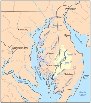
Marshyhope Creek is a 37.0-mile-long (59.5 km) tributary of the Nanticoke River on the Delmarva Peninsula. It rises in Kent County, Delaware, and runs through Caroline County, Maryland, and Dorchester County, Maryland.
The Hungry River flows in western North Carolina, United States. It arises in eastern Henderson County and flows southwesterly, its entire course within Henderson County, before it empties into the Green River. In 1904, the first hydroelectric plant in Henderson County was built on the river, and, in 1913, a second dam was built half a mile downstream for the same purpose. Both dams stand to his day, though they are currently inoperable and slated for removal under management of the North Carolina Wildlife Resources Commission.
The First Broad River is a tributary of the Broad River, about 60 mi (95 km) long in western North Carolina in the United States. Via the Broad and Congaree Rivers, it is part of the watershed of the Santee River, which flows to the Atlantic Ocean.
The Fisher River is a tributary of the Yadkin River in northwestern North Carolina in the United States, also draining a very small portion of southwestern Virginia. Via the Yadkin it is part of the watershed of the Pee Dee River, which flows to the Atlantic Ocean. According to the Geographic Names Information System, it has also been known historically as "Big Fishers River," "Fish River" and "Fishe River."
The Ararat River is a tributary of the Yadkin River in southwestern Virginia and northwestern North Carolina in the United States. Via the Yadkin it is part of the watershed of the Pee Dee River, which flows to the Atlantic Ocean.
Coleman River is a 6.6-mile-long (10.6 km) stream that is located in the Blue Ridge Mountains, mostly within Rabun County, Georgia. It is one of the main tributaries of the Tallulah River. The headwaters of Coleman River are located in Clay County, North Carolina, and the river travels a short distance before crossing into Georgia. The length of Coleman River in Rabun County is approximately 5.4 miles (8.7 km), with about 1.3 miles (2.1 km) traveling through private lands and about 4.1 miles (6.6 km) traveling through the Chattahoochee National Forest. The northern part of Coleman River in Georgia, from an elevation of about 2,800 feet (850 m) northward, together with the portion of Coleman River in North Carolina, is located in the Southern Nantahala Wilderness.
The Flat River is a river in southern Person County, North Carolina and a portion of Durham County, North Carolina.

The Rocky River is a 95-mile-long (153 km) river in the Piedmont region of North Carolina. It begins in Iredell County near Mooresville and flows south into Cabarrus County, where it is the principal waterway in the county. The river continues southeastward to form the line between Stanly, Union, and Anson counties. It empties into the Pee Dee River just below Norwood, North Carolina at the junction of Stanly, Montgomery, Anson, and Richmond counties, at the foot of the Uwharrie Mountains.

Abbotts Creek starts in Kernersville, NC in Forsyth County and becomes High Rock Lake near Lexington, NC in Davidson County just north of Hwy 47. The section of High Rock Lake that is officially Abbotts Creeks ends near the Hwy 8 causeway, in Southmont, NC.
Brasstown Creek is a stream in the U.S. states of Georgia and North Carolina. The 8.5-mile (13.7 km) long stream is a tributary to the Hiwassee River.
Terrells Creek is a 7.44 mi (11.97 km) long 3rd order tributary to the Haw River, left bank in Chatham County, North Carolina.
Great Coharie Creek is a 48.88 mi (78.66 km) long 5th order tributary to the Black River in Sampson County, North Carolina.
Mingo Swamp is a 21.78 mi (35.05 km) long 4th order tributary to the South River in Sampson County, North Carolina. Mingo Swamp along with Black River forms the South River.
Primehook Creek is a 7.85 mi (12.63 km) long 2nd order tributary to the Broadkill River in Sussex County, Delaware.
Slaughter Creek is a 9.92 mi (15.96 km) long 3rd order tributary to Cedar Creek in Sussex County, Delaware.


