
Poulton-le-Fylde, commonly shortened to Poulton, is a market town in Lancashire, England, situated on the coastal plain called the Fylde. In the 2021 United Kingdom census, it had a population of 18,115.

Fleetwood is a coastal town in the Borough of Wyre in Lancashire, England, at the northwest corner of the Fylde. It had a population of 25,939 at the 2011 census.

Cleveleys is a town on the Fylde Coast of Lancashire, England, about 4 miles (6 km) north of Blackpool and 2 miles (3 km) south of Fleetwood. It is part of the Borough of Wyre. With its neighbouring settlement of Thornton, Cleveleys was part of the former urban district of Thornton-Cleveleys and is part of the Blackpool Urban Area. In 2011 the Cleveleys Built-up area sub division had a population of 10,754.

The Amounderness Hundred is one of the six subdivisions of the historic county of Lancashire in North West England, but the name is older than the system of hundreds first recorded in the 13th century and might best be described as the name of a Norse wapentake. In the Domesday Book of 1086, it was used for some territories north of the River Ribble included together with parts of Yorkshire. The area eventually became part of Lancashire, sitting geographically between the Rivers Lune and Ribble, in the strip of coast between the Irish Sea and Bowland Forest.
Switch Island is a major road junction near Aintree in Merseyside, England, in the Metropolitan Borough of Sefton. The junction is at the western terminus of both the M57 and M58 motorways, which converge on the A59 trunk road, the north-south route from Liverpool. The junction is also the terminus of the A5036, a road which serves the Port of Liverpool, and the A5758 which serves as a bypass for the village of Thornton.
The Preston and Wyre Railway was promoted to open up agricultural land in the Fylde in Lancashire, access a new port at what became Fleetwood and the Lancaster Canal at Preston: it opened in 1840. An associated company built the dock leading to the company changing its name to the Preston and Wyre Railway, Harbour and Dock Company. Passenger business was more buoyant than expected, and the company built branch lines to the nascent resort of Blackpool and Lytham that opened in 1846. At that time the line was leased by the Lancashire and Yorkshire Railway and later the London and North Western Railway took a share in the lease which was later converted to outright ownership. The Preston and Wyre Railway continued to be jointly owned as the Preston and Wyre Joint Railway.
Thornton-Cleveleys is a conurbation consisting of the village of Thornton and the town of Cleveleys. The two settlements formed a joint urban district from 1927 until 1974, before becoming part of Wyre. The two settlements constitute part of the Blackpool Urban Area.
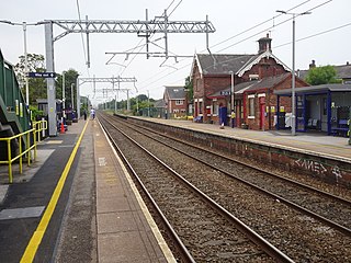
Poulton-le-Fylde railway station serves the town of Poulton-le-Fylde in Lancashire, England. It is managed by Northern Trains, but also served by Avanti West Coast and is 14+1⁄4 miles (22.9 km) northwest of Preston.

Bispham is a village on the Fylde coast in the Borough of Blackpool in Lancashire, England.
The Blackpool branch lines are two railway branch lines running from the West Coast Main Line at Preston to Blackpool: The main branch which is double track and electrified, runs to Blackpool North station via Poulton-le-Fylde. A second branch, which is single track and unelectrified, diverges from the main branch at Kirkham and Wesham junction, running on a southerly route to Blackpool South station via Lytham.
The Fleetwood branch line is a railway line that ran from Preston to Fleetwood. It passed through many smaller stations along the way, most of which are now closed. When work at Fleetwood docks was under threat in the mid-1960s, the main Fleetwood station was closed, and the remainder of the branch south to Poulton followed in 1970. There are active proposals to re-open the branch to passenger services.
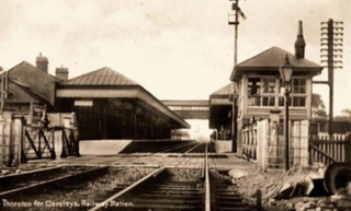
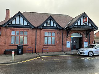
Thornton–Cleveleys was a railway station in England which served the Lancashire village of Thornton and town of Cleveleys. Located on the now disused line between Poulton-le-Fylde and Fleetwood, the station also had a shunting yard for the making-up of freight trains for Preston and beyond. During its life it was also known at times as Thornton station and Thornton for Cleveleys station. In the 1860s and early 1870s the line was of great importance, being the direct route from London to Glasgow. Before the Shap route was opened, passengers would travel from Euston to Fleetwood and then onwards via steamer to Scotland.
The A583 is a primary road from Preston to Blackpool in England, via Kirkham. It runs a distance of 17 miles (27.4 km), and was previously the main route into Blackpool until the construction of the M55 motorway.
The Fylde is a coastal plain in western Lancashire, England. It is roughly a 13-mile-long (21-kilometre) square-shaped peninsula, bounded by Morecambe Bay to the north, the Ribble estuary to the south, the Irish Sea to the west, and the foot of the Bowland hills to the east which approximates to a section of the M6 motorway and West Coast Main Line.

The A585 is a primary road in England which runs from Kirkham to Fleetwood in Lancashire.

The A587 is a road in England that runs from Blackpool to Fleetwood in Lancashire.

Skippool is an area of Thornton-Cleveleys, Lancashire, England. It is situated between Little Thornton and Poulton-le-Fylde along the western banks of the River Wyre, about three miles south of its mouth between Fleetwood and Knott End. These banks are known as Skippool Creek, an historic docks area now home to mostly run-down vessels. The MV Good Hope, for example, may date from the 1830s. Skippool Creek is a short branch off Main Dyke, which empties into the River Wyre in front of Blackpool and Fleetwood Yacht Club.

Raikes Farmhouse is an historic building in Thornton-Cleveleys, Lancashire, England. Replacing a building dating from at least 1595, the current structure was built in 1692, with a rear extension added in the 19th century. It has been designated a Grade II listed building by Historic England. The property is located on Raikes Road, just southeast of its junction with Stanah Road and Hillylaid Road.

Marsh Farmhouse is an historic building in Thornton-Cleveleys, Lancashire, England. Built in 1803, it is a Grade II listed building. It is located to the southeast of today's Amounderness Way roundabout at Victoria Road West.

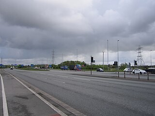
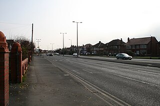
Four Lane Ends is a road junction in Thornton-Cleveleys, Lancashire, England. It is formed by the meeting of the north–south-running Fleetwood Road and the east–west-bound Victoria Road, the B5412. The names of both roads change in line with their directions at the junction, with Fleetwood Road North becoming Fleetwood Road South and Victoria Road East becomes Victoria Road West.


