
Glossop is a market town in the borough of High Peak, in the county of Derbyshire, England. It is located 15 miles (24 km) east of Manchester, 24 miles (39 km) north-west of Sheffield and 32 miles (51 km) north of the county town, Matlock. Glossop lies near Derbyshire's borders with Cheshire, Greater Manchester, South Yorkshire and West Yorkshire. It is between 150 and 300 metres above sea level and is bounded by the Peak District National Park to the south, east and north. In 2021 it had a population of 33,340.

Bakewell is a market town and civil parish in the Derbyshire Dales district of Derbyshire, England, known for Bakewell pudding. It lies on the River Wye, 15 miles (23 km) south-west of Sheffield. It is the largest settlement and only town within the boundaries of the Peak District National Park. At the 2011 census, the population of the civil parish was 3,949. It was estimated at 3,695 in 2019. The town is close to the tourist attractions of Chatsworth House and Haddon Hall.

The history of Derbyshire can be traced back to human settlement since the last Ice Age, over 10,000 years ago. The county of Derbyshire in England dates back to the 11th century.

Hayfield is a village and civil parish in High Peak, Derbyshire, England, with a population of around 2,700. The village is 3 miles (4.8 km) east of New Mills, 4.5 miles (7.2 km) south of Glossop and 10 miles (16 km) north of Buxton, in the basin of the River Sett.

Little Hayfield is a hamlet in the Peak District National Park, in Derbyshire, England. It lies on the A624 between Hayfield and Glossop. At the centre of the hamlet is the Lantern Pike pub, named after the nearby hill of the same name. Fell racing take place in Little Hayfield, and until 2021 an annual country show was held on a local farm, including sheepdog trials.

Rowarth is a hamlet about 2.5 miles (4 km) north of New Mills in the High Peak borough of Derbyshire, England. It is on the edge of the Peak District, in the hills between New Mills and Marple Bridge, within the parish boundary of New Mills.

Old Glossop is a parish village and the original part of the town of Glossop in the High Peak area of Derbyshire, England, about 15 miles (24 km) east of Manchester and 23 miles (37 km) west of Sheffield. The village is on the very edge of the Peak District national park. The town centre was originally this village, but it migrated to the west with the industrial revolution and the building of a planned mill town and the railway from Manchester to Sheffield and its branch to Glossop railway station just north of Norfolk Square.
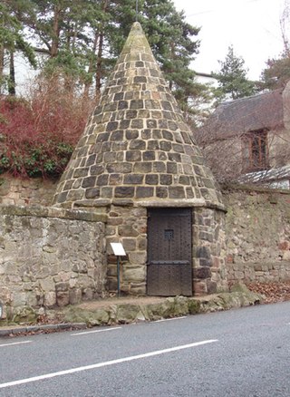
A village lock-up is a historic building once used for the temporary detention of people in England and Wales, mostly where official prisons or criminal courts were beyond easy walking distance. Lockups were often used for the confinement of drunks, who were usually released the next day, or to hold people being brought before the local magistrate. The archetypal form comprises a small room with a single door and a narrow slit window, grating or holes. Most lock-ups feature a tiled or stone-built dome or spire as a roof and are built from brick, stone and/or timber.
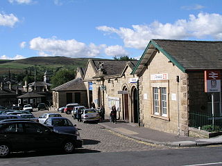
Glossop railway station serves the Peak District town of Glossop in Derbyshire, England. Glossop is the third busiest railway station in the county of Derbyshire after Derby and Chesterfield. It is located just north of Norfolk Square in the centre of Glossop.
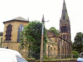
St. James's Church is an Anglican church in the evangelical tradition in the town of Glossop, Derbyshire, in the north-west of England. Along with St. Luke's Church, it makes up Whitfield Parish within Derby Diocese.

Chunal is a hamlet in Derbyshire, England. It is located on the A624 road, 1 mile south of Glossop. The philosopher Ludwig Wittgenstein conducted aeronautical research at Chunal during his time as an engineering research student at Manchester University (1908–1911). He flew kites into the upper atmosphere.

Whitfield is a hamlet and former parish in Derbyshire, England. It is half a mile (1km) south of Glossop Town Hall, south of Glossop Brook between Bray Clough and Hurst Brook. Whitfield was one of the original townships in the ancient Parish of Glossop. Up to the latter part of the 18th century the hamlet was devoted mostly to agriculture with an area of 2,608 statute acres. The area rises from about 169m to about 266m above mean sea level.

Chapel-en-le-Frith is a town and civil parish in the Borough of High Peak in Derbyshire, England.

Buxton Crescent is a Grade-I-listed building in the town of Buxton, Derbyshire, England. It owes much to the Royal Crescent in Bath, but has been described by the Royal Institution of British Architects as "more richly decorated and altogether more complex". It was designed by the architect John Carr of York, and built for the 5th Duke of Devonshire between 1780 and 1789. In 2020, following a multi-year restoration and redevelopment project supported by the National Heritage Memorial Fund and Derbyshire County Council, The Crescent was reopened as a 5-star spa hotel.

Glossop Town Hall, Market Hall, and Municipal Buildings is a complex in the centre of Glossop, Derbyshire, providing offices for High Peak Borough Council, a retail arcade, and covered market. The Town Hall was constructed in 1838 and significantly extended and altered in 1845, 1897 and 1923. The Town Hall building was designed by Weightman and Hadfield of Sheffield for the 12th Duke of Norfolk. It is constructed from millstone grit ashlar and topped with a distinctive circular cupola and clock. It is Grade II listed, forming a group with the market and Municipal Buildings to the south, and rows of shops to High Street West either side which were also part of Hadfield's design, and which marked the transition of Howard Town from a satellite industrial village to a freestanding urban entity.

Glossop Gas Works is a historic building in Glossop, England. It was constructed in the late 19th century on Arundel Street, Glossop, as the headquarters of the town's gas company.
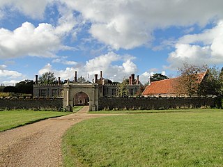
Hunstanton Hall, Old Hunstanton, Norfolk, England is a country house dating originally from the 15th century. The gatehouse, now detached from the main building, is dated 1487. The wings were built in the seventeenth century and there are Victorian additions. The house was the ancestral home of the L'Estrange family, resident from the time of Domesday until after World War II. During the early 20th century, P. G. Wodehouse, a friend of Charles Le Strange, was a frequent visitor and the hall features in his novel Money for Nothing (1928) and his collection of short stories Very Good, Jeeves (1930). The hall has also been suggested as a model for Blandings Castle. The building suffered two major fires, in 1853 and 1947. In 1948, the hall was sold and converted into apartments. Hunstanton Hall is a Grade I listed building.
Glossop is a market town in the High Peak district of Derbyshire, England. The town and surrounding areas, which include Dinting and Old Glossop, contain 56 listed buildings that are recorded in the National Heritage List for England. All the listed buildings are designated at Grade II, the lowest of the three grades, which is applied to "buildings of national importance and special interest". The town originated in what is now Old Glossop, where the older buildings are to be found, and in the 19th century its centre moved to the southwest, into the area known as New Glossop, or Howard Town centred around Norfolk Square. Most of the listed buildings are houses, cottages and farmhouses and associated structures, and the others include churches and items in churchyards, chapels, some of which have been converted for other uses, shops, public houses, public buildings, a market cross, a drinking trough, a former cotton mill, a railway station, a school, a bank, a theatre, a war memorial, and a pair of telephone kiosks.
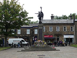
Glossop War Memorial is a 20th-century grade II listed war memorial in Norfolk Square in Glossop, Derbyshire.


