
Berwick-upon-Tweed, sometimes known as Berwick-on-Tweed or simply Berwick, is a town and civil parish in Northumberland, England, 2+1⁄2 mi (4 km) south of the Anglo-Scottish border, and the northernmost town in England. The 2011 United Kingdom census recorded Berwick's population as 12,043.
Islandshire was an area of Northumberland, England, comprising Lindisfarne or Holy Island, plus five parishes on the mainland.
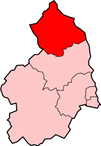
Berwick-upon-Tweed was a local government district and borough in Northumberland in the north-east of England, on the border with Scotland. The district had a resident population of 25,949 according to the 2001 census, which also notes that it is the most ethnically homogeneous in the country, with 99.6% of the population recording themselves in the 2001 census as White. It was also the least populated district in England with borough status, and the third-least densely populated local government district.
Salisbury was a local government district in Wiltshire, England from 1974 to 2009. Its main urban area was the city of Salisbury.
Rural districts were a type of local government area – now superseded – established at the end of the 19th century in England, Wales, and Ireland for the administration of predominantly rural areas at a level lower than that of the administrative counties.
Norhamshire was an exclave of County Durham in England. It was first mentioned in 995, when it formed part of the lands of the priory at Lindisfarne. When the lands north of the River Tees were partitioned into Northumberland and County Durham it, along with Bedlingtonshire and Islandshire, stayed under the jurisdiction of Durham despite being north of the River Tyne.

Norham is a village and civil parish in Northumberland, England, It is located 7 miles (11 km) south-west of Berwick on the south side of the River Tweed where it is the border with Scotland.

Berwick-upon-Tweed is a parliamentary constituency in Northumberland represented in the House of Commons of the UK Parliament since 2015 by Anne-Marie Trevelyan, a Conservative.

Buckingham Rural District was a rural district in the administrative county of Buckinghamshire, England from 1894 to 1974, covering an area in the north-west of the county. It was named after but did not include the borough of Buckingham.
Bucklow Rural District was, from 1894 to 1974, a local government district in the north of the administrative county of Cheshire, England. Following the Local Government Act 1972, this rural district was split between the new Greater Manchester boroughs of Trafford and Manchester, and Macclesfield, which was retained in Cheshire.
Banbury was a rural district in Oxfordshire, England from 1894 to 1974. It was formed under the Local Government Act 1894 from the bulk of the Banbury rural sanitary district, which had been divided among three counties. The Warwickshire part of the rural sanitary district formed the Farnborough Rural District, whilst the area in Northamptonshire formed the Middleton Cheney Rural District.
Henley was a rural district in Oxfordshire, England from 1894 to 1974.

The Diocese of Durham is a Church of England diocese, based in Durham, and covering the historic county of Durham. It was created in AD 635 as the Diocese of Lindisfarne. The cathedral is Durham Cathedral and the bishop is the Bishop of Durham who used to live at Auckland Castle, Bishop Auckland, and still has his office there. The diocese's administrative centre, the Diocesan Office, is located at Cuthbert House, Stonebridge just outside Durham City. This was opened in 2015.
Abingdon was a rural district in the administrative county of Berkshire from 1894 to 1974.

The Anglo-Scottish border is a border separating Scotland and England which runs for 96 miles (154 km) between Marshall Meadows Bay on the east coast and the Solway Firth in the west.

Scremerston is a village in Northumberland, England. The village lies on the North Sea coast just under 2.5 miles (4 km) south of Berwick-upon-Tweed and 4.3 miles (7 km) from the Anglo-Scottish border. It is adjacent to the A1, providing access to Newcastle upon Tyne to the south, and to Edinburgh to the north.
The History of local government districts in Buckinghamshire began in 1835 with the formation of poor law unions. This was followed by the creation of various forms of local government body. In 1894 the existing arrangements were replaced with a system of municipal boroughs, urban and rural districts, which remained in place until 1974.
Witney Rural District was a rural district in Oxfordshire, England from 1894 to 1974. It surrounded but did not include the town of Witney.
