
Wounded Knee is a census-designated place (CDP) on the Pine Ridge Indian Reservation in Oglala Lakota County, South Dakota, United States. The population was 364 at the 2020 census.
Fedora is an unincorporated community in Miner County, South Dakota, United States, founded in 1881. The Census Bureau began tracking Fedora as a CDP in 2010. Fedora has been assigned the ZIP code of 57337. The population of the CDP was 26 at the 2020 census.
Lantry is an unincorporated community and a census-designated place (CDP) in Dewey County, South Dakota, United States. The population of the CDP was 33 at the 2020 census.
Lyons is an unincorporated community and census-designated place (CDP) in Minnehaha County, South Dakota, United States. The CDP had a population of 70 at the 2020 census. Lyons has been assigned the ZIP code of 57041.
Meckling is an unincorporated community and a census-designated place (CDP) in Clay County, South Dakota, United States. The population was 48 at the 2020 census.
Okreek is an unincorporated community in Todd County, South Dakota, United States. As of the 2020 Census, the population was 190. The town is wholly within the jurisdiction of the Rosebud Indian Reservation, and the populace is almost entirely Sioux-American. Okreek consists primarily of two long blocks of inhabited tract housing, and has about 30 private telephone subscribers within town limits. There is also an elementary school and a Post Office which has been assigned the ZIP Code of 57563.
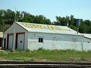
Oral is an unincorporated community and census-designated place (CDP) in Fall River County, South Dakota, United States. The population was 66 at the 2020 census.
Saint Onge is an unincorporated community and census-designated place (CDP) in Lawrence County, South Dakota, United States. As of the 2020 census, the population was 170.
Smithwick is an unincorporated community and census-designated place (CDP) in Fall River County, South Dakota, United States. The population was 39 at the 2020 census. Smithwick has been assigned the ZIP code of 57782.
Stephan is an unincorporated community and census-designated place (CDP) in Hyde County, South Dakota, United States. Stephan has been assigned the ZIP code of 57346. The population of the CDP was 68 at the 2020 census.
Winfred is an unincorporated community and census-designated place (CDP) in Lake County, South Dakota, United States, approximately 12 miles (19 km) west of Madison. The population was 38 as of the 2020 census.
Richland is a small unincorporated community and census-designated place (CDP) in Union County, South Dakota, United States. The population was 97 at the 2020 census.
Shindler is an unincorporated community and census-designated place (CDP) in Lincoln County, South Dakota, United States. The population was 607 at the 2020 census.
Ideal is an unincorporated community in northern Tripp County, South Dakota, United States. It lies north of the city of Winner, the county seat. Its elevation is 1,886 feet (575 m). The population of the CDP was 86 at the 2020 census.
Forestburg is an unincorporated town and census-designated place in Sanborn County, South Dakota, United States. The population was 54 at the 2020 census.
Crocker is an unincorporated community and census-designated place (CDP) in Clark County, South Dakota, United States. The population was 19 at the 2020 census.
Boulder Canyon is an unincorporated area and census-designated place (CDP) in Lawrence County, South Dakota, United States. The population was 561 at the 2020 census. It was first listed as a CDP prior to the 2020 census.
Wonderland Homes is an unincorporated, developed "neighborhood" community in Meade County, South Dakota, United States, consisting of numerous homes in subdivisional layout and several small businesses. Its origins are unknown, as is its relationship to other places or real estate development businesses called "Wonderland Homes". It is in the southwest part of Meade county, on the eastern edge of the Black Hills. It is bordered to the southwest by the town of Summerset and to the north by the town of Piedmont, to which towns it is sometimes connected as might be a subdivision. Exit 48 on Interstate 90 is 0.5 miles (1 km) to the west; I-90 leads northwest 17 miles (27 km) to Sturgis, the county seat, and southeast 11 miles (18 km) to Rapid City.
White Rock Colony is a census-designated place (CDP) and Hutterite colony in Roberts County, South Dakota, United States, partly within the Lake Traverse Indian Reservation. It was first listed as a CDP prior to the 2020 census. The population of the CDP was 0 at the 2020 census.
Peever Flats is an unincorporated community and census-designated place (CDP) in Roberts County, South Dakota, United States, within the Lake Traverse Indian Reservation. It was first listed as a CDP prior to the 2020 census. The population of the CDP was 129 at the 2020 census.


