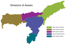
North Assam Division | |
|---|---|
 The five divisions of Assam | |
| Country | |
| State | Assam |
| Capital | Tezpur |
| Largest City | Tezpur |
| Area | |
• Total | 6,613 km2 (2,553 sq mi) |
| Population (2011 census) | |
• Total | 3 684 298 |
North Assam is an administrative division of Assam under the jurisdiction of a Commissioner, who is officially stationed at Tezpur. It consists of the following districts: Udalguri, Darrang, Sonitpur and Biswanath. Shri Rakesh Kumar, IAS is the current Commissioner of this division. [1]