North College Hill, Ohio

Last updated

North College Hill, Ohio
Cary cottage 3380.jpg
Clovernook, childhood home of poets Alice and Phoebe Cary
Flag of North College Hill, Ohio.png
Logo of North College Hill, Ohio.png
Hamilton County Ohio Incorporated and Unincorporated areas North College Hill highlighted.svg
Location in Hamilton County and the state of Ohio
Coordinates: 39°13′03″N84°33′07″W / 39.21750°N 84.55194°W / 39.21750; -84.55194
Country United States
State Ohio
County Hamilton
Government
  MayorTracie Nichols (D) [1]
Area
[2]
  Total1.83 sq mi (4.73 km2)
  Land1.82 sq mi (4.72 km2)
  Water0.01 sq mi (0.01 km2)
Elevation
[3]
824 ft (251 m)
Population
 (2020)
  Total9,663
  Estimate 
(2022) [4]
9,484
  Density5,306.43/sq mi (2,049.35/km2)
Time zone UTC-5 (Eastern (EST))
  Summer (DST) UTC-4 (EDT)
ZIP codes
45224, 45239, 45231
Area code 513
FIPS code 39-56322 [5]
GNIS feature ID1086223 [3]
Website www.northcollegehill.org

North College Hill is a city in Hamilton County in the southwestern part of the U.S. state of Ohio approximately ten miles north of downtown Cincinnati. As of the 2020 census, the city population was 9,663. The city takes its name from its proximity to the Cincinnati neighborhood of College Hill (formerly Pleasant Hill) which borders it to the south.

Contents

History

One of the first easterners to survey the area was John Cleves Symmes, a judge and former Congressman from New Jersey, after whom Symmes Township is named. Symmes visited the area in 1787 and received tentative permission from the new Federal government to purchase a section of land between the Little Miami and Great Miami Rivers. This tract became known as the “Symmes Purchase” or “Miami Purchase” and extended south to the Ohio River. [6]

Several of the pioneers who migrated across the midwest to claim a part of Symmes' tract are buried in North College Hill's oldest landmark, the LaBoiteaux-Cary cemetery. Established in approximately 1806, the cemetery includes the graves of two Revolutionary War veterans and several members of the Cary family. The last burial in the cemetery was in 1860. [7]

Cary family

In 1813–14, William Cary, having migrated from New Hampshire to Cincinnati in 1802, [8] purchased 491 acres (1.99 km2) north of Cincinnati along what is now Hamilton Avenue (U.S. Route 127). Cary built a log cabin and moved his family to this “wilderness,” then known as Mill Creek Township. [9]

Soon after, William Cary purchased an additional 75 acres (300,000 m2) north of North Bend Road adjacent to his original tract, and sold part of it to his nephew Robert Cary. Robert called the land Clovernook Farm and initially erected a small frame house for his family. In 1832, he built the white, brick house now known as Cary Cottage (see photo) which stands on the campus of the Clovernook Center for the Blind and Visually Impaired and is listed on the National Register of Historic Places. [10] Within a year of his settlement, Robert also laid out the first community in the area, called Clovernook, on the east side of Hamilton Avenue.

Robert Cary and his wife Elizabeth raised nine children, two of whom, Alice and Phoebe, became well-known poets and writers. Both girls began having their poems published as teenagers, and they eventually counted among their admirers Massachusetts poet and abolitionist John Greenleaf Whittier, New York Tribune newspaper editor Horace Greeley, and author Edgar Allan Poe, who pronounced Alice Cary's Pictures of Memory , "one of the most musically perfect lyrics in the English language". [11]

Cary Cottage became the first home for blind women in Ohio through the work of the Trader sisters, Florence and Georgia (who was blind). In 1903 the Cary house and the land surrounding it were purchased by William Procter, grandson of the Procter & Gamble co-founder, in order to give them in trust to the Traders. The sisters used the land to establish the Clovernook home and provide employment to visually impaired women as a source of dignity and direction. Today, the Clovernook Center for the Blind and Visually Impaired offers instruction, employment, community living and low vision services for men and women, and runs three manufacturing departments, including one of the world's largest volume producers of Braille publications. [12]

Isaac Mayer Wise

In the latter part of the nineteenth century, North College Hill was the home of Dr. Isaac Mayer Wise, who has been called “the most prominent Jew of his time in the United States” [13] for his influence as one of the early leaders of Reform Judaism in America.

In 1861, Wise and his wife Therese bought a house and 42-acre (170,000 m2) farm near the current intersection of Goodman and Hamilton Avenues, where they raised a family of ten children. [14] Wise added to the original farmhouse until it included 13 rooms on various levels. The farm, meanwhile, allowed him to carry out agricultural experiments and to enjoy the opportunity to own his own land. [15]

A park near the site of his former farm was dedicated to Wise. In 2022, the park was renovated and re-dedicated. [16]

Tumey v. Ohio

In 1925, North College Hill Mayor A. R. Pugh was involved in a Prohibition case. [17] [18] Ohio law allowed small towns like North College Hill to operate "liquor courts". These courts had authority over their entire county. Further, the Crabbe Act allowed local towns, mayors, and police departments to keep at least some of the fines imposed by these courts. [19] In Tumey v. Ohio (1927), the U.S. Supreme Court ruled the Crabbe Act was unconstitutional as financial conflicts of interest impaired the right to a fair trial. [20] The court's decision in this case continues to provide precedent today in cases involving judicial impartiality. [21] [22]

Development of a community

Through the nineteenth century, as College Hill to the south and Mount Healthy to the north matured into towns, the area that was to become North College Hill remained largely farmland. Beginning in 1905, saw mill owner John Meyer used his surplus lumber to build a subdivision of small homes north of Galbraith Road and west of Hamilton Avenue and called it Meyerville. Within the next ten years, two other groups of homes – Clovernook, east of Hamilton Avenue, and Sunshine, south of Galbraith and west of Hamilton – were started. The three subdivisions, with a total of about 500 residents, were incorporated as the Village of North College Hill in 1916. [7]

As the automobile stretched commuting distances, the village's affordable housing attracted a growing population, and it increased from about 1,100 to 4,100 residents during the 1920s. In 1941, the village incorporated as a City and continued to grow until the population stabilized at its peak of around 12,000 by 1960. [23] A few homes were removed for the completion of Ronald Reagan Cross County Highway (Ohio State Route 126) in 1997. Population has declined more or less steadily over the past four decades, according to the U.S. Census: 1970 12,363; 1980 10,990; 1990 11,002; 2000 10,082; 2010 9,397. [24] [25]

In 2007, Money magazine listed the city sixth among places "where homes are affordable". [26] On November 6, 2007 a ballot initiative to make North College Hill a charter city was passed by the voters. [27] In 2011 North College Hill was rated the "best place to raise kids in Ohio" by Bloomberg Businessweek, based on such factors as school performance, the number of schools, crime statistics, cost of living, job growth, air quality, ethnic diversity, and access to recreational facilities. [28]

Geography

According to the United States Census Bureau, the city has a total area of 1.83 square miles (4.74 km2), all land. [29]

Demographics

Memorial Day parade in North College Hill Nch memorial day parade.jpg
Memorial Day parade in North College Hill
Historical population
CensusPop.Note
1920 1,104
1930 4,139274.9%
1940 5,23126.4%
1950 7,92151.4%
1960 12,03551.9%
1970 12,3632.7%
1980 11,114−10.1%
1990 11,002−1.0%
2000 10,082−8.4%
2010 9,397−6.8%
2020 9,6632.8%
2022 (est.)9,484−1.9%
Sources: [30] [31] [5] [32]

2020 census

As of the census of 2020, there were 9,663 people living in the city, for a population density of 5,306.43 people per square mile (2,049.35/km2). There were 4,247 housing units. The racial makeup of the city was 33.0% White, 58.6% Black or African American, 0.4% Native American, 0.7% Asian, 0.1% Pacific Islander, 1.3% from some other race, and 6.0% from two or more races. 2.5% of the population were Hispanic or Latino of any race. [33]

There were 3,461 households, out of which 43.0% had children under the age of 18 living with them, 29.9% were married couples living together, 14.4% had a male householder with no spouse present, and 44.9% had a female householder with no spouse present. 26.9% of all households were made up of individuals, and 6.2% were someone living alone who was 65 years of age or older. The average household size was 2.71, and the average family size was 3.40. [33]

30.6% of the city's population were under the age of 18, 60.0% were 18 to 64, and 9.4% were 65 years of age or older. The median age was 32.6. For every 100 females, there were 86.5 males. [33]

According to the U.S. Census American Community Survey, for the period 2016-2020 the estimated median annual income for a household in the city was $51,120, and the median income for a family was $56,504. About 25.3% of the population were living below the poverty line, including 40.7% of those under age 18 and 10.3% of those age 65 or over. About 61.7% of the population were employed, and 19.2% had a bachelor's degree or higher. [33]

2010 census

As of the census [34] of 2010, there were 9,397 people, 3,848 households, and 2,325 families residing in the city. The population density was 5,135.0 inhabitants per square mile (1,982.6/km2). There were 4,267 housing units at an average density of 2,331.7 per square mile (900.3/km2). The racial makeup of the city was 49.0% White, 46.6% African American, 0.1% Native American, 0.6% Asian, 0.1% Pacific Islander, 0.4% from other races, and 3.2% from two or more races. Hispanic or Latino of any race were 1.3% of the population.

There were 3,848 households, of which 32.9% had children under the age of 18 living with them, 32.9% were married couples living together, 21.6% had a female householder with no husband present, 6.0% had a male householder with no wife present, and 39.6% were non-families. 33.5% of all households were made up of individuals, and 9.9% had someone living alone who was 65 years of age or older. The average household size was 2.39 and the average family size was 3.05.

The median age in the city was 36.2 years. 25.3% of residents were under the age of 18; 9% were between the ages of 18 and 24; 27.9% were from 25 to 44; 25.7% were from 45 to 64; and 12.1% were 65 years of age or older. The gender makeup of the city was 47.3% male and 52.7% female.

2000 census

As of the census [5] of 2000, there were 10,082 people, 4,191 households, and 2,535 families residing in the city. The population density was 5,491.0 inhabitants per square mile (2,120.1/km2). There were 4,488 housing units at an average density of 2,444.3 per square mile (943.7/km2). The racial makeup of the city was 76.20% White, 21.69% African American, 0.23% Native American, 0.26% Asian, 0.01% Pacific Islander, 0.47% from other races, and 1.15% from two or more races. Hispanic or Latino of any race were 0.59% of the population.

There were 4,191 households, out of which 30.2% had children under the age of 18 living with them, 42.2% were married couples living together, 14.9% had a female householder with no husband present, and 39.5% were non-families. 34.4% of all households were made up of individuals, and 14.4% had someone living alone who was 65 years of age or older. The average household size was 2.33 and the average family size was 3.03.

In the city the population was spread out, with 25.5% under the age of 18, 7.5% from 18 to 24, 31.5% from 25 to 44, 17.5% from 45 to 64, and 18.0% who were 65 years of age or older. The median age was 36 years. For every 100 females, there were 85.3 males. For every 100 females age 18 and over, there were 78.9 males.

The median income for a household in the city was $37,776, and the median income for a family was $45,149. Males had a median income of $31,964 versus $27,710 for females. The per capita income for the city was $18,915. About 6.8% of families and 8.7% of the population were below the poverty line, including 11.5% of those under age 18 and 10.3% of those age 65 or over.

Government

Mayors of North College Hill

From 1941 to 1966, the mayoral term was two years. The term was extended to four years in 1967.

No.NameStart day
and month
Start
year
End day
and month
End
year
Time in
office
Political Party
1Edward C. AhlersJanuary 11942December 3119432 yearsDemocratic
2John J. TomkinsJanuary 11944December 3119474 yearsDemocratic
3Robert J. ReussJanuary 11948December 31195912 yearsRepublican
4Frank X. NiehausJanuary 11960December 3119634 yearsDemocratic
5Robert BornemanJanuary 11964December 3119652 yearsRepublican
6Joseph G. BinderJanuary 11966December 3119672 yearsDemocratic
7Robert BornemanJanuary 11968December 3119714 yearsRepublican
8Charles W. PieperJanuary 11972December 3119754 yearsRepublican
9Joseph G. BinderJanuary 11976December 3119794 yearsDemocratic
10Charles L. WoesteJanuary 11980November 1819833 years, 10 months, 18 daysRepublican
11Charlotte H. KunkelNovember 191983December 31198343 daysRepublican
12 Daniel R. Brooks January 11984December 21201329 years, 11 months, and 20 daysDemocratic
13Amy A. BancroftDecember 262013September 2120151 year, 8 months, 27 daysDemocratic
14Maureen MasonOctober 52015December 3120194 years, 2 months, and 26 daysDemocratic
15Tracie NicholsJanuary 120204 years, 144 daysDemocratic

See also

Related Research Articles

<span class="mw-page-title-main">Fairfield, Ohio</span> City in Ohio, United States

Fairfield is a city in southern Butler County, Ohio, United States. It is a suburb located about 25 miles (40 km) north of Cincinnati and is situated on the east bank of the Great Miami River. The population was 44,907 as of the 2020 census. Incorporated in 1955 from portions of Fairfield Township, it includes the former hamlets of Symmes Corner, Fair Play, Furmandale, and Stockton. The Fairfield City School District is one of the largest in Ohio and serves both the City of Fairfield and Fairfield Township.

<span class="mw-page-title-main">Hamilton County, Ohio</span> County in Ohio, United States

Hamilton County is located in the southwestern corner of the U.S. state of Ohio. As of the 2020 census, the population was 830,639, making it the third-most populous county in Ohio. The county seat and largest city is Cincinnati. The county is named for the first Secretary of the Treasury, Alexander Hamilton. Hamilton County is part of the Cincinnati-Middletown, OH-KY-IN Metropolitan Statistical Area.

<span class="mw-page-title-main">Trenton, Ohio</span> City in Ohio, United States

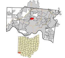
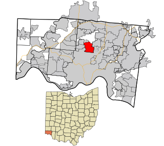
Trenton is a city in northeastern Butler County, Ohio, United States, west of Middletown. The population was 13,021 at the 2020 census. It is part of the Cincinnati metropolitan area.

<span class="mw-page-title-main">Blue Ash, Ohio</span> City in Ohio, United States

Blue Ash is a city in Hamilton County, Ohio. An inner suburb of Cincinnati, the population was 13,394 at the time of the 2020 census.

<span class="mw-page-title-main">Cleves, Ohio</span> City in Ohio, United States

Cleves is a village in Miami Township, Hamilton County, Ohio, United States. Located along the Ohio River, it is a western suburb of Cincinnati. The population was 3,414 at the 2020 census.

<span class="mw-page-title-main">Finneytown, Ohio</span> CDP in Ohio, United States

Finneytown is a census-designated place (CDP) in Springfield Township, Hamilton County, in southwest Ohio, United States, just north of Cincinnati. The population was 12,399 at the 2020 census. Finneytown is home to the second largest private school in Ohio and the Cincinnati area's annual Greek Festival.

<span class="mw-page-title-main">Montgomery, Ohio</span> City in Ohio, United States

Montgomery is a city in Hamilton County, Ohio, United States. It is an eastern suburb of Cincinnati. The population was 10,853 at the 2020 census.

<span class="mw-page-title-main">Mount Healthy, Ohio</span> City in Ohio, United States

Mount Healthy is a city in Hamilton County, Ohio, United States. It is a suburb of Cincinnati. The population was 6,996 at the 2020 census.

<span class="mw-page-title-main">North Bend, Ohio</span> Village in Ohio, United States

North Bend is a village in Miami Township, Hamilton County, Ohio, United States, along the Ohio River. It is a part of the Greater Cincinnati area. The population was 835 at the 2020 census.

<span class="mw-page-title-main">Indian Hill, Ohio</span> City in Ohio, United States

The Village of Indian Hill is a city in Hamilton County, Ohio, United States, and a suburb of the Greater Cincinnati area. The population was 6,087 at the 2020 census. Prior to 1970, Indian Hill was incorporated as a village, but under Ohio law became designated as a city once its population was verified as exceeding 5,000. The municipality then changed its name to add "Village" into the official name; legally it is "The City of The Village of Indian Hill". The Village of Indian Hill is served by the Indian Hill Exempted Village School District.

<span class="mw-page-title-main">Sharonville, Ohio</span> City in Ohio, United States

Sharonville is a city largely in Hamilton County in the U.S. state of Ohio. The population was 14,117 at the 2020 census.

<span class="mw-page-title-main">Columbia Township, Hamilton County, Ohio</span> Township in Ohio, United States

Columbia Township is one of the twelve townships of Hamilton County, Ohio, United States. The 2020 census found 4,446 people in the township. Originally one of Ohio's largest townships by area at its inception in 1791, it gradually shrank to one of the smallest by the early 1950s.

<span class="mw-page-title-main">Green Township, Hamilton County, Ohio</span> Township in Ohio, United States

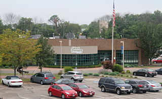
Green Township is one of the twelve townships of Hamilton County, Ohio, United States. It is a suburb of the neighboring city of Cincinnati. With a population of 60,424 at the 2020 census, Green Township is the most populous township in Hamilton County, and the second most populous township in Ohio. It was founded in 1809.

<span class="mw-page-title-main">Symmes Township, Hamilton County, Ohio</span> Township in Ohio, United States

Symmes Township is one of the twelve townships of Hamilton County, Ohio, United States. The population was 15,642 as of the 2020 census.

<span class="mw-page-title-main">Camp Dennison, Ohio</span> Census-designated place in Ohio, United States

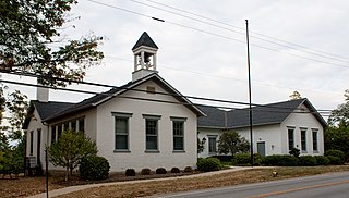
Camp Dennison is a census-designated place (CDP) just outside Indian Hill in southern Symmes Township, Hamilton County, Ohio, United States. It has a post office with the ZIP code 45111. The population was 384 at the 2020 census.

<span class="mw-page-title-main">College Hill, Cincinnati</span> Neighborhood of Cincinnati in Hamilton, Ohio, United States

College Hill is one of the 52 neighborhoods of Cincinnati, Ohio. Established in 1813 and annexed in 1911, 1915, and 1923, it is located in the northwestern part of the city. It was originally called Pleasant Hill due to its prime location, but was later renamed College Hill because of the two colleges that were established there in the mid-nineteenth century. The neighborhood is not to be confused with North College Hill, which borders College Hill to the north but is not part of Cincinnati. The population was 16,039 at the 2020 census.

<span class="mw-page-title-main">Mack, Ohio</span> Census-designated place in Ohio, United States

Mack is a census-designated place (CDP) in Green and Miami townships, Hamilton County, Ohio, United States. The population was 11,088 at the 2020 census. At prior censuses, the community was listed as two separate CDPs, Mack North and Mack South.

<span class="mw-page-title-main">Concorde Hills, Ohio</span> Census-designated place in Ohio, United States

Concorde Hills is a census-designated place (CDP) in Sycamore Township, Hamilton County, Ohio, United States. The population was 644 at the 2020 census.

<span class="mw-page-title-main">Salem Heights, Hamilton County, Ohio</span> Census-designated place in Ohio, United States

Salem Heights is a census-designated place (CDP) in Anderson Township, Hamilton County, Ohio, United States, adjacent to the city of Cincinnati. The population of Salem Heights was 3,862 at the 2020 census.

<span class="mw-page-title-main">Sixteen Mile Stand, Ohio</span> Census-designated place in Ohio, United States

Sixteen Mile Stand is a census-designated place (CDP) in Symmes Township, Hamilton County, Ohio, United States, 19 miles (31 km) northeast of downtown Cincinnati. The population of Sixteen Mile Stand was 3,091 at the 2020 census.

References

  1. "Tracie Nichols elected first Black mayor of North College Hill". Cincinnati Herald. November 23, 2019. Retrieved September 20, 2022.
  2. "ArcGIS REST Services Directory". United States Census Bureau. Retrieved September 20, 2022.
  3. 1 2 U.S. Geological Survey Geographic Names Information System: North College Hill, Ohio
  4. "QuickFacts North College Hill city, Ohio". United States Census Bureau. Retrieved September 27, 2023.
  5. 1 2 3 "U.S. Census website". United States Census Bureau . Retrieved January 31, 2008.
  6. "The History of Symmes Township Archived 2008-07-04 at the Wayback Machine ," Symmes Township, Ohio, . Retrieved on 3/16/2008.
  7. 1 2 Smiddy, Betty Ann, editor, “A Little Piece of Paradise...College Hill, Ohio, Second Edition,” College Hill Historical Society, 2008, pp. 37-38.
  8. William Cary - Person Sheet, Ancestry.com. Retrieved on 6/29/2008.
  9. Mill Creek Township, History of Cincinnati and Hamilton County, Ohio. Retrieved on 3/16/2008.
  10. Venable, W. H., Beginnings of Literary Culture in the Ohio Valley, Robert Clarke & Co., 1891.
  11. "The Cary Sisters Archived 2007-12-13 at the Wayback Machine ,” Unitarian Universalist Historical Society. Retrieved on 3/23/2008.
  12. "Clovernook's History Archived 2011-07-25 at the Wayback Machine ,” Clovernook Center for the Blind and Visually Impaired. Retrieved on 6/29/2008.
  13. Adler, Cyrus and Philipson, David, "Isaac Mayer Wise,” Jewish Encyclopedia.com. Retrieved on 3/30/2008.
  14. Fine, John S. and Krome. Frederic J., Images of America: Jews of Cincinnati, Arcadia Publishing, 2007.
  15. Cincinnati: A Guide to the Queen City and Its Neighbors, The Wisen-Hart Press, 1943, pp. 500-501.
  16. "2022 Wise Park Renovation". North College Hill website. Retrieved September 4, 2022.
  17. "Tumey v. Ohio, 273 U. S. 510,” US Supreme Court Center. Retrieved on 3/9/2008.
  18. Menez, Joseph Francis and Vile, John R., “Tumey v. Ohio, 273 U.S. 510; 47 S. Ct. 437; 71 L. Ed. 749 (1927),” Summaries of Leading Cases on the Constitution, Rowman & Littlefield, 2003, p. 387.
  19. Okrent, Daniel (May 11, 2010). Last Call: The Rise and Fall of Prohibition . Scribner. loc 4842 (Kindle). ISBN   978-0743277020.
  20. "Tumey v. Ohio". Ohio History central. Retrieved March 5, 2020.
  21. Blount, Jim, "U. S. Supreme Court decision stopped crusading village mayors Archived 2007-10-26 at the Wayback Machine ,” Journal-News, February 12, 2003. Retrieved on 3/30/2008.
  22. Layman, James, “Judicial Campaign Speech Regulation: Integrity or Incentives?,” Georgetown University Law Center, Summer 2006.
  23. A Brief History of North College Hill,” City of North College Hill. Retrieved on 1/23/2017.
  24. Historical Appendices: Population in Cities in Ohio Archived 2013-07-12 at the Wayback Machine ,” Secretary of State, Ohio. Retrieved on 12/1/2011.
  25. Ohio County Profiles Archived 2011-11-19 at the Wayback Machine ,” Department of Development, Ohio. Retrieved on 12/1/2011.
  26. Where homes are affordable,” Money Magazine, July 7, 2007. Retrieved on 4/27/2008.
  27. Issue 37: Proposed Charter - Hamilton County, OH. Retrieved on July 12, 2008.
  28. The Best Places to Raise Your Kids 2011 Archived 2011-11-25 at the Wayback Machine ,” Bloomberg Businessweek. Retrieved on 12/1/2011.
  29. "US Gazetteer files 2010". United States Census Bureau. Archived from the original on February 20, 2011. Retrieved January 6, 2013.
  30. "Number of Inhabitants: Ohio" (PDF). 18th Census of the United States. U.S. Census Bureau. 1960. Retrieved April 24, 2020.
  31. "Ohio: Population and Housing Unit Counts" (PDF). U.S. Census Bureau. Retrieved November 22, 2013.
  32. "North College Hill, Ohio". census.gov. Retrieved July 6, 2022.
  33. 1 2 3 4 "North College Hill city, Ohio - Census Bureau Profile". United States Census Bureau. Retrieved October 3, 2023.
  34. "U.S. Census website". United States Census Bureau . Retrieved January 6, 2013.