
The Dinaric Alps, also Dinarides, are a mountain range in Southern and Southcentral Europe, separating the continental Balkan Peninsula from the Adriatic Sea. They stretch from Italy in the northwest through Slovenia, Croatia, Bosnia and Herzegovina, Serbia, Montenegro, and Kosovo to Albania in the southeast.

The Herzegovina-Neretva Canton is one of 10 cantons of the Federation of Bosnia and Herzegovina in Bosnia and Herzegovina.

The Neretva, also known as Narenta, is one of the largest rivers of the eastern part of the Adriatic basin. Four HE power-plants with large dams provide flood protection, power and water storage. It is recognized for its natural environment and diversity of its landscape.

Case White, also known as the Fourth Enemy Offensive, was a combined Axis strategic offensive launched against the Yugoslav Partisans throughout occupied Yugoslavia during World War II. It was one of the most significant confrontations of World War II in Yugoslavia. The offensive took place in early 1943, between 20 January and mid-to-late March. The Axis operation prompted the Partisan Supreme Command to enact its plans to drive toward eastern Herzegovina, Sandžak and Montenegro.
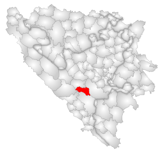
Jablanica is a town and municipality located in Herzegovina-Neretva Canton of the Federation of Bosnia and Herzegovina, an entity of Bosnia and Herzegovina. It is situated on the Neretva river and Jablanica lake.
Buško Lake, also known as Buško Blato or Buško Jezero is an accumulation lake located near the Croatian border on the south side of Livanjsko Polje and northwest of Duvanjsko Polje in Canton 10, a canton of the Federation of Bosnia and Herzegovina, one of the two entities of Bosnia and Herzegovina. The name is also a reference to the area surrounding the lake which includes a number of villages, of which Prisoje is the largest.
The Trebišnjica is a river in Bosnia and Herzegovina. It used to be a sinking river, 96.5 km (60.0 mi) long above the ground. With a total length of 187 km (116 mi) above and under the ground, it is one of the longest sinking rivers in the world.
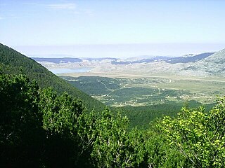
Blidinje Nature Park is a nature park in Bosnia and Herzegovina, established on 30 April 1995. It is situated at the Blidinje plateau, in the heart of Dinaric Alps, between major mountains of the range, Čvrsnica, Čabulja and Vran, with characteristic karstic features such as Dugopolje field, Blidinje Lake, Grabovica and Drežanka valleys, and others. It represents important natural, hydrogeological reserves in Dinaric karst of Bosnia and Herzegovina, with significant cultural and historical heritage.

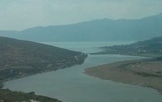
Jablaničko lake is a large artificially formed lake on the Neretva river, right below Konjic where the Neretva expands into a wide valley. The river provided lot of fertile, agricultural land there, before the lake flooded most of it. The lake was created in 1953 after construction of Jablanica Dam near Jablanica in central Bosnia and Herzegovina.

Salmo marmoratus, the marble trout, is a species of freshwater fish in the family Salmonidae. It is characterized by a distinctive marbled color pattern and high growth capacity. The marble trout is found in only a handful of drainages and rivers of the Adriatic basin in Italy, Slovenia, Croatia, Bosnia and Herzegovina, and Montenegro, while in Albania, the species is considered most likely extirpated.

Konjic is a city and municipality located in Herzegovina-Neretva Canton of the Federation of Bosnia and Herzegovina, an entity of Bosnia and Herzegovina. It is located in northern Herzegovina, around 60 kilometres (37 mi) southwest of Sarajevo. It is a mountainous, heavily wooded area, and is 268 m (879 ft) above sea level. The municipality extends on both sides of the Neretva River. According to the 2013 census, city has a population of 10,732 inhabitants, with 25,148 inhabitants in the municipality.

Herzegovina is the southern and smaller of two main geographical regions of Bosnia and Herzegovina, the other being Bosnia. It has never had strictly defined geographical, cultural or historical borders, nor has it ever been defined as an administrative whole in the geopolitical and economic subdivision of Bosnia and Herzegovina.

Rakitnica is the main tributary of the first section of the Neretva river, also called Upper Neretva (Bosnian: Gornja Neretva). It meets Neretva from the right, flowing from north to south, between Bjelašnica and Visočica mountains.

The Trebižat is a river in the southern part of Bosnia and Herzegovina, and major right tributary of the Neretva River.

Glavatičevo is a small village in Konjic Municipality, Bosnia and Herzegovina, which is a central village to a group of villages of a wider Glavatičevo, positioned 30 km southeast of Konjic, within a wide Župa Valley straddling the Neretva river. The village and its wider areal, with surrounding villages and the valley, is also referred to as Župa Glavatičevo, or Komska Župa, or simply Župa.

Upper Neretva, is the upper course of the Neretva river, including vast mountainous area surrounding the Neretva, with numerous human settlements, peaks and forests, numerous streams and well-springs, three major glacial lakes near the river and even more scattered across the mountains of Treskavica and Zelengora, in a wider area of the Upper Neretva with its flora and fauna.

Rama is a river in Bosnia and Herzegovina, and a major tributary of the Neretva. It joins it from the right by discharging into Neretva's artificial reservoir, Jablaničko lake, at place called Marina Pećina, near village of Gračac, between location of underground powerhouse of Rama Hydroelectric Power Station and Jablanica Dam, depending on water level in Jablaničko lake, some 15 kilometers upstream from Jablanica.

The Sarajevo–Ploče railway is a 194-kilometre (121-mile) long railway in Bosnia and Herzegovina and Croatia. The line connects Sarajevo with Konjic, Mostar and Ploče. The route operates through the regions of Sarajevo Canton, Herzegovina-Neretva Canton and Dubrovnik-Neretva County. The route largely follows the route of the Neretva river. Passenger services along the full length of line have been discontinued between 2013 and 2022, running only between Sarajevo and the town of Čapljina on the Bosnian-Croatian border. International train service between Sarajevo and Ploče resumed on 1 July 2022, on weekends until September 1st, using Spanish-designed Talgo wagons. The line is part of the pan-European corridor 5C from Budapest via Osijek and Sarajevo to Ploče. The section through Bosnia and Herzegovina is marked 11, and through Croatia M304.
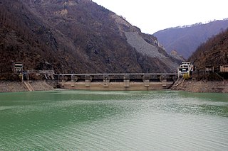
The Jablanica Dam is an arch-gravity dam on the Neretva River about 4 km (2.5 mi) northwest of Jablanica in the Herzegovina-Neretva Canton of Bosnia and Herzegovina. The dam was constructed between 1947 and 1955 with the primary purpose of hydroelectric power production. The power station was commissioned in two stages, from 1955 until 1958. The first generator was commissioned in February 1955. An upgrade in 2008 increased the installed capacity of the power station from 150 MW to 180 MW. The dam's power station is located about 4.4 km (2.7 mi) to the southeast near Jablanica and discharges back into the Neretva River. It contains six 30 MW Francis turbine-generators for an installed capacity of 180 MW. The difference in elevation between the reservoir and power station afford a hydraulic head of 111 m (364 ft). The dam is 85 m (279 ft) tall and creates Jablanica lake. The dam and power station are owned and operated by Elektroprivreda Bosne i Hercegovine.

