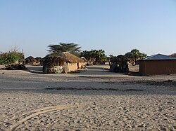
Samburu County is a county in the former Rift Valley Province, Kenya. It covers an area of roughly 21,000 km² (8,000 mi²) in northern Kenya where the Samburu, Turkana and many other tribes live. It stretches north from the Wuaso Ng'iro River to the south of Lake Turkana. According to the 2019 census, the county has a population of 310,327.

Busia is a county in the former Western Province of Kenya. It borders Kakamega County to the east, Bungoma County to the north, Lake Victoria and Siaya County to the south and Busia District, Uganda to the west. The county has about 893,000 people and spins about 1,700 square kilometers making it one of the smallest counties in Kenya. Busia is inhabited by the Iteso tribe of Kenya with smaller groups of Luhya and Luo. The Luhya communities include the Abakhayo, Marachi, Samia and Abanyala communities.
Laikipia County is one of the 47 counties of Kenya, located on the Equator in the former Rift Valley Province of the country. Laikipia is a cosmopolitan county and is county number 31. The county has two major urban centres: Nanyuki to the southeast, and Nyahururu to the southwest. Its capital is Rumuruti. The County lies between latitudes 0o 18” South and 0 o 51” North and between longitude 36o 11” and 37o 24’ East. It borders Samburu County to the North, Isiolo County to the North East, Meru County to the East, Nyeri County to the South East, Nyandarua County to the South, Nakuru County to the South West and Baringo County to the West.

Lamu County is located in the Northern Coast of Kenya and is one of the Six Coastal Counties in Kenya. It borders Tana River County in the southwest, Garissa County to the north, Republic of Somalia to the northeast and the Indian Ocean to the South. It lies 1° 40’ and 2° 30’south and longitude 40° 15’ and 40° 38’south. The County has a land surface of 6,273.1 km that include the mainland and over 65 islands that form the Lamu Archipelago. The total length of the coastline is 130 km while land water mass area stands at 308 km.

Siaya County is one of the counties in the former Nyanza Province in the southwest part of Kenya. It is bordered by Busia County to the north, Kakamega County and Vihiga County's to the northeast and Kisumu County to the southeast. It shares a water border with Homa Bay County which is located south of Siaya County. The total area of the county is approximately 2,496.1 km². The county lies between latitude 0° 26’ to 0° 18’ north and longitude 33° 58’ east and 34° 33’ west. Siaya has been split up into six new districts. Under the Constitution 2010, the role of districts are still unclear as much of administrative authority is being transferred to the county. The capital is Siaya, even though the largest town is Bondo.

Siaya is a town in Siaya County of Kenya. It is the capital of Siaya County. It is located 74 kilometres northwest of Kisumu, the provincial capital. The urban center had a population of 33,153 in 2019.

Kiambu County is a county in the former Central Province of Kenya. Its capital is Kiambu and its largest town is Thika. Kiambu County borders Nairobi and Kajiado Counties to the South, Machakos to the East, Murang‘a to the North and North East, Nyandarua to the North West, and Nakuru to the West and has a population of 2,417,735.
Kilifi County is a county of Kenya. It was formed in 2010 as a result of a merger of Kilifi District and Malindi District. Its capital is Kilifi and its largest town is Malindi. The county has a population of 1,453,787. It covers an area of 12,245.90 km2 (4,728.17 sq mi).

Marsabit County is a county of Kenya. Covering a surface area of 66.923,1 square kilometres Marsabit is the largest county in Kenya. Its capital is Marsabit and its largest town Moyale. According to the 2019 census, the county has a population of 459,785. It is bordered to the North by Ethiopia, to the West by Turkana County to the South by Samburu County and Isiolo County, and to the East by Wajir County.
Isiolo County is a county in the former Eastern Province of Kenya. Its population is 268,002 and its capital is Isiolo. Isiolo County is to be the first county to be developed as part of the Kenya Vision 2030 program. Its capital and largest town is Isiolo. Other upcoming urban centres are: Garbatulla, Modogashe, Kinna, Merti and Oldonyiro.

Nyamira County is a county in the former Nyanza Province of Kenya. It was formerly part of Kisii County when Kisii County was a district, and is sometimes called North Kisii County. The main cash crops grown are bananas and tea. The county has a population of 605,576. Its capital and largest town is Nyamira, with an urban population of around 41,668

Kitui County is a county in the former Eastern Province of Kenya. Its capital and largest town is Kitui, although Mwingi is also another major urban centre. The county has a population of 1,136,187. and an area of 30,430 km². It lies between latitudes 0°10 South and 3°0 South and longitudes 37°50 East and 39°0 East.

Mandera County is a county in the former North Eastern Province of Kenya. Its capital and largest town is Mandera. The county is bordered by Ethiopia to the north, by Somalia to the east and by Wajir County to the southwest. According to the 2019 census, the county has a population of 867,457 and an area of 25,939.8 km². The main economic activity in the county is pastoralism, while others include cross-border trade with Ethiopia, artisanal mining, beekeeping and agriculture along the Dawa River.
Under its old constitution, Kenya comprised eight provinces each headed by a Provincial Commissioner. The provinces were subdivided into districts (wilaya). There were 69 districts at the 1999 census. Districts were then subdivided into 497 divisions (taarafa). The divisions are then subdivided into 2,427 locations (mtaa) and then 6,612 sublocations.

North Horr Constituency is an electoral constituency in Kenya. It is one of four constituencies in Marsabit County. The entire constituency is located within Marsabit County Council area. The constituency was established for the 1988 elections. It is the largest constituency in Kenya on land coverage and hosts the only true desert in Kenya, Chalbi desert. Kenya's well known politician Godana Bonaya was its first member of parliament, and he represented the constituency until his demise in a Kenya Air Force Y-12 plane crash on 10 April 2006 in which all the legislators from Marsabit county perished.
Makueni Constituency is an electoral constituency in Kenya. It is one of six constituencies in Makueni County. The constituency was established for the 1966 elections.
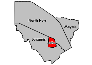
Marsabit central is an electoral constituency in Kenya. It is one of four constituencies in Marsabit County in Northern Kenya. It borders North Horr Constituency to the North and Laisamis Constituency to the South. The constituency was established for the 1988 elections. Marsabit town which is the county headquarters is in Saku constituency.
Mandera West Constituency is an electoral constituency in Kenya that was established for the 1966 elections. It is one of six constituencies in Mandera County. It has eight wards, all electing councillors to the Mandera County Council.