
Rocky Mountain National Park is an American national park located approximately 76 mi (122 km) northwest of Denver International Airport in north-central Colorado, within the Front Range of the Rocky Mountains. The park is situated between the towns of Estes Park to the east and Grand Lake to the west. The eastern and western slopes of the Continental Divide run directly through the center of the park with the headwaters of the Colorado River located in the park's northwestern region. The main features of the park include mountains, alpine lakes and a wide variety of wildlife within various climates and environments, from wooded forests to mountain tundra.

Kennesaw Battlefield Park preserves a Civil War battleground of the Atlanta Campaign, and also contains Kennesaw Mountain. It is located at 905 Kennesaw Mountain Drive, between Marietta and Kennesaw, Georgia. The name "Kennesaw" derives from the Cherokee Indian "Gah-nee-sah" meaning "cemetery" or burial ground. The area was designated as a U.S. historic district on October 15, 1966.

Trail Ridge Road is the name for a stretch of U.S. Highway 34 that traverses Rocky Mountain National Park from Estes Park, Colorado in the east to Grand Lake, Colorado in the west. The road is also known as Trail Ridge Road/Beaver Meadow National Scenic Byway.

Grand Lake is Colorado's largest and deepest natural lake. It is located in the headwaters of the Colorado River in Grand County, Colorado. On its north shore is located the historic and eponymous town of Grand Lake. The lake was formed during the Pinedale glaciation, which occurred from 30000 BP to 10000 BP. The glacial terminal moraine created a natural dam. Natural tributaries to the lake are the North Inlet and East Inlet, both of which flow out of Rocky Mountain National Park, which surrounds the lake on three sides. Grand Lake is located 1 mile from the Park's western entrance. Grand Lake was named Spirit Lake by the Ute Tribe because they believed the lake's cold waters to be the dwelling place of departed souls.

Grand Portage National Monument is a United States National Monument located on the north shore of Lake Superior in northeastern Minnesota that preserves a vital center of fur trade activity and Anishinaabeg Ojibwe heritage. The area became one of the British Empire's four main fur trading centers in North America, along with Fort Niagara, Fort Detroit, and Michilimackinac.

Chugach State Park covers 495,204 acres immediately east of the Anchorage Bowl in south-central Alaska. Though primarily in the Municipality of Anchorage, a small portion of the park north of the Eklutna Lake area in the vicinity of Pioneer Peak lies within the Matanuska-Susitna Borough. Established by legislation signed into law on August 6, 1970, by Alaska Governor Keith Miller, this state park was created to provide recreational opportunities, protect the scenic value of the Chugach Mountains and other geographic features, and ensure the safety of the water supply for Anchorage. The park, managed by Alaska State Parks, is the third-largest state park in the United States, and consists of geographically disparate areas each with different attractions and facilities. Only Anza-Borrego Desert State Park in California and Wood-Tikchik State Park in western Alaska are larger. Hunting and fishing are permitted in the Chugach under regulations established by the Alaska Department of Fish and Game for game management unit 14c. Target practice is not allowed within the park boundaries.

Rock Harbor is the main access point for visitors landing on Isle Royale in northern Lake Superior. It sits 4 miles from the northeastern end of the forty-five mile long island, the whole of which is protected as Isle Royale National Park. Two structures in Rock Harbor -- the Rock Harbor Light and the Edisen Fishery -- are listed on the National Register of Historic Places.

Bald Mountain State Recreation Area is a 4,637-acre (1,877 ha) state park located near Lake Orion, Michigan off M-24. It consists of some of the most rugged terrain in southeastern Michigan. The recreation area is composed of a North Unit and a South Unit, which are not contiguous. The South Unit itself includes two parts separated by M-24, but the section west of M-24 has no recreational facilities or trails and is primarily undeveloped forest and grassy plains segmented by a few through-roads.

There are more than 1,500 properties and historic districts in Colorado listed on the National Register of Historic Places. They are distributed over 63 of Colorado's 64 counties; only Broomfield County has none.

The Moses H. Cone Memorial Park is a country estate in honor of Moses H. Cone in Blowing Rock, North Carolina. It is on the Blue Ridge Parkway between mileposts 292 and 295 with access at milepost 294. Most locals call it Cone Park. The park is run by the National Park Service and is open to the public. It contains 3,500 acres (14 km2), a 16-acre (65,000 m2) trout lake, a 22-acre (89,000 m2) bass lake, and 25 miles (40 km) of carriage trails for hiking and horses. The main feature of the park is a twenty-three room 13,000-square-foot (1,200 m2) mansion called Flat Top Manor built around the early 1900s. At the manor, there is a craft shop and demonstration center, along with an information desk and book store.

The Kootenai Creek Snowshoe Cabin was built in Glacier National Park in 1926. The rustic log structure comprises a single room with a woodstove, and a small cellar food cache. The cabin was situated on the patrol route from the Goat Haunt ranger station to the Fifty Mountain-Flattop region, about eight miles upstream from the ranger station. Unlike most patrol cabins, it is isolated from the park's main trail routes.
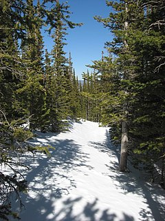
The Flattop Mountain Trail, also known as the Grand Trail or the Big Trail, was built in 1925 in Rocky Mountain National Park in the Larimer County portion of the U.S. state of Colorado. Built in 1925, and rehabilitated in 1940 with Civilian Conservation Corps labor, it is listed on the National Register of Historic Places. The trail begins at 9500 feet of elevation at Bear Lake and climbs Flattop Mountain to a maximum elevation of 12,324 feet on the Continental Divide.

Hallett Peak is a mountain summit in the northern Front Range of the Rocky Mountains of North America. The 12,720-foot (3,877 m) peak is located in the Rocky Mountain National Park Wilderness, 10.1 miles (16.2 km) southwest by west of the Town of Estes Park, Colorado, United States, on the Continental Divide between Grand and Larimer counties.
This is a complete list of the properties and districts on the National Register of Historic Places in Rocky Mountain National Park, Colorado, United States. The locations of National Register properties and districts for which the latitude and longitude coordinates are included below, may be seen in a Google map.

The East Inlet Trail in Rocky Mountain National Park, Colorado, was established in 1913 to provide access from Grand Lake to a series of lakes 6 miles (9.7 km) to the east of Grand Lake. The trail originates at the east stream inlet to Grand lake: confusingly, it is close to the west portal of the Alva B. Adams Tunnel which conveys water from the west side of the Continental Divide under the park to the east slope of the Rocky Mountains. The trail was developed further in the 1920s, but was still considered to be in poor condition. In the 1930s further improvements were made, and in 1934 workers from the Public Works Administration rebuilt the section between Lone Pine Lake and Lake Verna. In 1940 workers from the Civilian Conservation Corps improved three miles of trail beyond Adam Falls, building causeway sections through swampy areas. The trail was rebuilt again in 1970, and was improved between 2000 and 2003 with stone steps and handrails at Adam Falls.
Architects of the National Park Service are the architects and landscape architects who were employed by the National Park Service (NPS) starting in 1918 to design buildings, structures, roads, trails and other features in the United States National Parks. Many of their works are listed on the National Register of Historic Places, and a number have also been designated as National Historic Landmarks.

The Lost Lake Trail near Estes Park, Colorado, also known as, or including, Sawmill Trail, is a 9-mile-long (14 km) trail through what is now Roosevelt National Forest and then through what is now Rocky Mountain National Park (RMNP).

Shadow Mountain Trail is a trail 4.8 miles (7.7 km) long on the east side of Shadow Mountain Lake, near Grand Lake, Colorado. It is also known as, or is associated with, Echo Mountain Trail, Lookout Mountain Trail and Pine Ridge Trail. The trail was rebuilt in 1930 by the National Park Service; trail design reflects NPS Naturalistic Design of the 1920s to 1940s.

Bierstadt Lake is located in Larimer County, Colorado and within the Rocky Mountain National Park. Near McHenrys Peak and Longs Peak, there are "spectacular views" of the Continental Divide at the lake. The Bierstadt Lake Trailhead is located about 6.5 miles (10.5 km) from the turn-off at U.S. Route 36 into the Rocky Mountain National Park. During the summer, shuttle buses provide transportation to the trailhead.
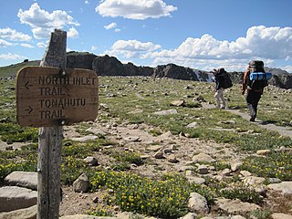
The Tonahutu Creek Trail, in the general area of Grand Lake, Colorado, in both Grand and Larimer counties, was listed on the National Register of Historic Places in 2008.


