
The Banggai Regency is a regency located at the eastern end of Central Sulawesi Province of Indonesia. It makes up a re-established regency (kabupaten), created on 4 October 1999 by splitting the existing Banggai Regency into this smaller Banggai Regency situated on the mainland of Sulawesi and a new Banggai Islands Regency comprising the offshore islands which are separated from mainland Sulawesi by the Peleng Straits. The residual Banggai Regency covers an area of 9,672.70 km2 and had a population of 323,626 at the 2010 census and 362,275 at the 2020 census; the official estimate as at mid 2022 was 366,224.

Gorontalo is a regency of Gorontalo Province, Indonesia, on the island of Sulawesi. It was established in 1959 under Law Number 29/1959, but has subsequently been reduced in area as additional regencies have been cut out of it. It now has an area of 2,125.47 km2 and had a population of 355,988 at the 2010 Census and 393,107 at the 2020 Census; the official estimate as at mid 2022 was 398,801. The administrative headquarters of the regency is in the town of Limboto.

North Gorontalo is a regency of Gorontalo Province, Indonesia, stretching along the entire northern coast of the province. It is located on the northern peninsula of the island of Sulawesi. It was established in 2007 under Law Number 11/2007 from the former northern districts of Gorontalo Regency. The new regency has an area of 1,777.02 km2, and it had a population of 104,133 at the 2010 Census and 124,957 at the 2020 Census; the official estimate as at mid 2022 was 128,563. Its regency seat is the town of Moluo in Kwandang District.

Manggarai Regency is a regency in East Nusa Tenggara province of Indonesia, situated on the island of Flores. Established in 1958 the regency was reduced in size and population by the separation of the more western districts to form West Manggarai Regency in 2003 and of the more eastern districts to form East Manggarai Regency in 2007. The area of the residual Manggarai Regency is 1,343.83 km2 and its population was 292,037 at the 2010 census and 312,855 at the 2020 census; the official estimate as at mid 2023 was 328,758. The capital of the regency is the town of Ruteng.

Konawe Regency is one of the regencies in the province of Southeast Sulawesi, Indonesia. The capital of the regency is Unaaha. The regency was once known as the district of Kendari. The regency had a population of 241,428 at the 2010 Census, but was subsequently reduced by the separation of the offshore island districts as the new Konawe Islands Regency in 2013. It now covers 6,087.68 km2 and had a population of 257,011 at the 2020 Census; the official estimate as at mid 2023 was 262,439. Prior to its division in 2003, 2007 and 2013, Konawe was known as the rice granary of the province of Southeast Sulawesi because half of the province's rice production comes from the Konawe regencies.

Pasangkayu Regency is one of the six regencies which comprise West Sulawesi Province, Indonesia, on the island of Sulawesi. It covers an area of 3,043.75 km2 and had a population of 134,303 at the 2010 Census and 188,861 at the 2020 Census. The official estimate as at mid 2022 was 198,608. The town of Pasangkayu is the capital and chief town of the regency.

North Barito Regency is one of the thirteen regencies which divide the Central Kalimantan Province on the island of Kalimantan, Indonesia. It originally included much more of the northern part of the province, but on 10 April 2002 the larger northwestern part of the regency was split off to create a new Murung Raya Regency. Muara Teweh is the capital of North Barito Regency, which covers an area of 10,152.25 km2. The population of North Barito Regency was 121,573 at the 2010 Census and 154,812 at the 2020 Census; the official estimate as at mid 2022 was 160,235.

North Luwu Regency is a regency of South Sulawesi Province of Indonesia. It was created on 20 April 1999 by separation of the province's northern districts formerly within the Luwu Regency; however on 25 February 2003 it was reduced when the easternmost of these same districts were split off to create the East Luwu Regency. It now covers 7,502.58 km2 and had a population of 287,606 at the 2010 census and 322,919 at the 2020 census; the official estimate as at mid 2022 was 327,820. The principal town lies at Masamba.

The Pangkajene and Islands Regency, is a regency of South Sulawesi province of Indonesia. The regency lies primarily on the mainland of Sulawesi's southern peninsula, but also includes the Spermonde Islands off the west coast of that peninsula, as well as other small islands further west and southwest. The principal town lies at Pangkajene on Sulawesi, but there are a series of further small towns like Lejang, Labakkang, Bonto-Bonto and Segeri proceeding northwards from Pangkajene along the Trans-Sulawesi Highway. The total land area is 1,112.29 km2, and the population was 305,737 at the 2010 Census and 345,775 at the 2020 Census; the official population estimate as of mid-2022 was 351,426.

Takalar Regency is a regency of South Sulawesi Province, Indonesia. It covers an area of 566.51 km2 and had a population of 269,603 at the 2010 census and 300,853 at the 2020 census; the official estimate for mid 2022 was 305,077. The entire regency lies within the official metropolitan area of the city of Makassar. The principal towns are at Galesong and Takalar, but the administrative centre is at Pattallassang.

Kolaka Regency is a regency of Southeast Sulawesi Province, Indonesia. It covers an area of 2,960.73 km2 (1,143.14 sq mi) and had a population of 208,817 at the 2010 Census, rising to 237,587 at the 2020 Census; the official estimate as at mid 2023 was 247,680. The principal town lies at Kolaka.
North Buton Regency is a regency of Indonesia's Southeast Sulawesi Province, which was separated from Buton Regency in accordance with Indonesia's Law Number 14 of 2007. The area of the regency, which covers the north part of Buton Island, is 1,923.03 km2. Its population was 54,736 at the 2010 Census and 66,653 at the 2020 Census; the official estimate as at mid 2023 was 72,757. The administrative capital of the regency is at the town of Buranga, in Bonegunu District.

North Kolaka Regency is a regency in the northwest part of Southeast Sulawesi province of Indonesia. It was created on 18 December 2003 from the former northern districts of Kolaka Regency. It covers an area of 2,932 km2, and had a population of 121,476 at the 2010 Census, and 137,700 at the 2020 Census; the official estimate as at mid 2023 was 140,488 - comprising 71,995 males and 68,493 females. The principal town lies at Lasusua.

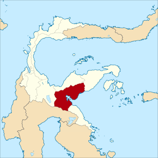
South Konawe Regency is a regency of Southeast Sulawesi Province, Indonesia. The regency was created on 25 February 2003 from what had been the southern districts of Konawe Regency. It covers an area of 4,237.74 km2 and had a population of 264,587 at the 2010 Census and of 308,524 at the 2020 Census; the official estimate as at mid 2023 was 322,946 - comprising 165,487 males and 157,459 females.< The administrative centre is in the town of Andoolo.

Tojo Una-Una Regency is a regency of Central Sulawesi, Indonesia. The administrative centre is at Ampana town, on the Sulawesi 'mainland'. While the Regency includes a considerable area on the eastern peninsula of Sulawesi, it also includes the Togian Islands in the Gulf of Tomini. The total area covers 5,721.51 km2 and the population was 134,945 at the 2010 Census and 163,829 at the 2020 Census; the official estimate as at mid 2022 was 169,478.

Minahasa Regency is a regency in North Sulawesi, Indonesia. Its capital is Tondano. It covers an area of 1,141.64 km2 and had a population of 310,384 at the 2010 Census; this rose to 347,290 at the 2020 Census, and the official estimate as at mid 2022 was 350,317.

The East Kolaka Regency is a new and the only landlocked regency of Southeast Sulawesi, Indonesia, established on 11 January 2013 from the former eastern nine districts of the Kolaka Regency. The administrative centre lies at Tirawuta; its current Regent is Abdul Aziz. The area is 3,991.78 km2, and the population at the 2020 census was 120,699; the official estimate as at mid 2023 was 126,754 - comprising 65,337 males and 61,417 females.

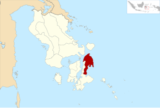
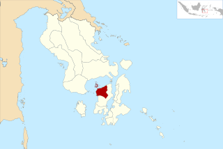
Konawe Islands Regency is an insular regency in the province of Southeast Sulawesi, Indonesia, established on 15 May 2013 from that former insular part of Konawe Regency which consisted of the seven districts comprising Wawonii Island. It covers an area of 867.58 km2, and had a population of 28,944 at the 2010 Census and 37,050 at the 2020 Census; the official estimate as at mid 2023 was 41,520. The administrative centre lies at the town of Langara.
North Morowali Regency is a regency in the province of Central Sulawesi, Indonesia. The regency was established on 12 April 2013, partitioned from the northwestern districts of Morowali Regency. It covers an area of 10,004.28 km2 and the component districts them in Morowali Regency had a combined population of 104,094 at the 2010 Census. The new regency had 120,789 inhabitants at the 2020 Census; the official estimate as at mid 2022 was 124,006. The principal town lies at Kolonodale.
West Muna Regency is a new regency of Southeast Sulawesi Province of Indonesia,and is situated in the northwest corner of Muna Island and smaller ilsands of its coast. It was established under Act No.14 of 2014, dated 23 July 2014 by separation from the Muna Regency. It covers an area of 906.28 km2, and the districts comprising it had a population of 71,632 at the 2010 Census; the 2020 Census resulted in a population of 84,590, and the official estimate as at mid 2022 was 85,706, comprising 42,242 males and 43,464 females. The administrative centre lies at Laworo in the Tiworo Islands District.


