North Macedonia under the Ottoman Empire

Last updated

North Macedonia was part of the Ottoman Empire for over 500 years, from the late 14th century until the Treaty of Bucharest in 1913. [1] Before its conquest, this area was divided between various Serbian feudal principalities. Later, it became part of the Ottoman province or Eyalet of Rumelia. The name Rumelia (Turkish: Rumeli) means "Land of the Romans" in Turkish, referring to the lands conquered by the Ottoman Turks from the Byzantine Empire. [1]

Contents

History

Conquests

In the Battle of Maritsa of 1371, the King of Lordship of Prilep Vukašin Mrnjavčević and his brother Jovan Uglješa led 70,000 men against the Ottomans. Despite having smaller numbers, the Ottomans managed to kill Vukašin and his brother and win the Battle of Maritsa. [2]

After the battle, most of Serbia broke into smaller principalities. One of those principalities is known as the Kingdom of Prilep, led by Vukašin's son Marko. [3] Like most regional rulers in the Macedonian region, Marko accepted vassalage under Sultan Murad I to preserve his position.

The Battle of Kosovo of 1389 sealed the fate of the region of Macedonia for the next 500 years. While both armies lost leaders and large numbers of soldiers, the Ottomans could easily assemble another army just as large while the locals could not.

Marko died alongside Konstantin Dragaš at the Battle of Rovine in 1395 and the territory of his realm became the Sanjak of Ohrid. [4] [5]

All of Vardar Macedonia was under Ottoman control by the early of the 15th century, with Skopje falling under Turkish rule on January 19, 1392. [6] [7] Aside from conflict with Skanderbeg's forces, in which areas of western part of the region of Macedonia became a battleground of Ottoman–Albanian war for more than 20 years (1444–1467), the Ottoman Empire ultimately succeeded in taking the region, incorporating it into Rumelia Eyalet. [8]

Rumelia Eyalet

The reduced eyalet in the 1850s Rumelia Eyalet, Ottoman Balkans 1850s.png
The reduced eyalet in the 1850s

From its foundation, the province of Rumelia encompassed the entirety of the Ottoman Empire's European possessions. The first capital of Rumelia was probably Edirne (Adrianople), which was also, until the Fall of Constantinople in 1453, the Ottomans' capital city. In the 18th century, Monastir (present day Bitola) emerged as an alternate residence of the governor, and in 1836, it officially became the capital of the eyalet. At about the same time, the Tanzimat reforms, aimed at modernizing the Empire, split off the new eyalets of Üsküb, Yanya and Selanik and reduced the Rumelia Eyalet to a few provinces around Monastir. The rump eyalet survived until 1867, when, as part of the transition to the more uniform vilayet system, it became part of the Salonica Vilayet. [9] [10]

The reduced Rumelia Eyalet, centred at Manastir, encompassed also the sanjaks of Iskenderiyye (Scutari), Ohri (Ohrid) and Kesrye (Kastoria). In 1855, according to the French traveller A. Viquesnel, it comprised the sanjaks of Iskenderiyye, with 7 kazas or sub-provinces, Ohri with 8 kazas, Kesrye with 8 kazas and the pasha-sanjak of Manastir with 11 kazas. [11]

Vilayets

Map of Vilayets in the geographical region of Macedonia 1907. Vilayets in the region of Macedonia 1907.png
Map of Vilayets in the geographical region of Macedonia 1907.

After administrative reform in 1860s, the Ottoman Empire was divided into vilayets which were subdivided into sanjaks.

Kosovo Vilayet

The northern part of the Macedonian region was included in the Kosovo Vilayet. Sanjaks located in this vilayet that contained territory now within the Republic of North Macedonia were:

Monastir Vilayet

The southwestern part of the region was located in the Monastir vilayet. Sanjaks located in this vilayet that contained territory now within the Republic of North Macedonia were:

Salonika Vilayet

The southeastern part of the region was located in the Salonika vilayet. Sanjaks located in this vilayet that contained territory now within the Republic of North Macedonia were:

1881/82 Ottoman General Census

Ottoman censuses did not count ethnic groups, but rather millets, and increasingly from the 1870s onwards, ethnoconfessional groups. Thus, "Muslims" in the 1881/82 Census covered all adherents of Islam, regardless if they were ethnic Turks, Slavs, Albanians, Romani, etc. "Greeks" referred to all Greeks and to any Vlachs, Albanians and Slavs, who considered themselves to be Greek (or Serbian). "Bulgarians"comprised only those (Christian) Slavs, who considered themselves Bulgarians.

Thus, according to the Ottoman General Census of 1881/82, the population of the kazas currently falling within the borders of the Republic of North Macedonia is divided into the following ethnoconfessional grou[s: [12]

Ethnoconfessional groups in kazas currently part of the Republic of North Macedonia as per the 1881-82 Ottoman Census [12]
Kaza1BulgariansMuslimsGreeksMiscellaneous2Kaza total
Number%Number%Number%Number%Number%
Köprülü32,84364.018,09335.24200.80-51,356100%
Tikveş21,31951.319,90947.82600.6320.141,520100
Gevgili5,78414.917,06344.014,55837.51,4023.638,807100
Toyran5,60520.619,42358.21,5915.95512.027,170100
Usturumca2,9749.015,76047.713,72641.65641.733,024100
Selanik Vilayet Subtotal68,52535.790,24847.030,55515.92,5491.3191,877100
Üsküp22,49732.140,25657.36,6559.57621.170,170100
Karatova19,61881.84,33218.1330.10-23,985100
Kumanova29,47870.512,26829.3870.280.041,841100
Planka18,19688.12,07810.13881.80-20,662100
İştip17,57541.624,16657.20-5151.242,251100
Kaçana33,12059.722,23940.1830.20-55,442100
Radovişte7,36441.010,51958.50-970.517,980100
Kalkandelen9,83022.429,21266.34,99011.30-44,032100
Kosova Vilayet Subtotal157,67849.8145,07045.912,2363.91,3820.4316,363100
Monastir61,49444.730,51722.241,07729.94,3653.2137,453100
Ohri33,30663.216,36031.03,0495.80-52,685100
Pirlepe43,76373.814,27024.01,2482.1420.159,327100
Kirçova20,87960.113,28238.8640.240.034,229100
Monastir Vilayet Subtotal159,44256.274,42926.245,43816.04,4111.6283,694100
NORTH MACEDONIA borders385,64548.7309,74739.188,22911.18,3421.1791,963100
1 The kaza of Dibra did not participate in the census.
2 The "Miscellaneous" category includes, among other things, Jews—numbering 4,274 in Monastir, 724 in Üsküp, 573 in Usturumca, 515 in İştip, 167 in Toyran, etc.; Greek Catholic (Uniate) Bulgarians—numbering 1,402 in Gevgili, 376 in Toyran. etc.; Protestants—numbering 97 in Radovişte, and so on.

Balkan Wars

The Balkan Wars consisted of two wars that occurred in 1912 and 1913. The first began on 8 October 1912 when the nations of the Balkan League, who had large parts of their ethnic populations under Ottoman rule, attacked the Ottoman Empire. It lasted seven months with the Balkan League nations coming up victorious, ending 500 years of Ottoman rule in the Balkans. [13]

Vardar Macedonian cities under Ottoman rule

After falling under Ottoman rule, many mosques and other Islamic buildings, such as the Isa Bey Mosque, were built in the cities like Skopje Ishak-begova dzamija u Skoplju.JPG
After falling under Ottoman rule, many mosques and other Islamic buildings, such as the Isa Bey Mosque, were built in the cities like Skopje

During the Ottoman rule of the Balkans, cities experienced many changes with regards to the demographic makeup of their population and the look of their cityscapes. With laws that prohibited Christian buildings from being higher than Islamic ones, the skylines of cities like Üsküp (Skopje) and Manastır (Bitola) were dominated by minarets. [14]

Ottoman traveller Evliya Çelebi visited the city of Manastır in 1661. He wrote that of the seven mosques in the city at the time, six were built in the 16th century. Most of the mosques constructed on the territory of today's Republic of North Macedonia were square in shape with a three-domed portico and a minaret on the building's right side. [15]

See also

Related Research Articles

<span class="mw-page-title-main">Bitola</span> City in Pelagonia, North Macedonia

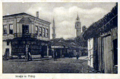
Bitola is a city in the southwestern part of North Macedonia. It is located in the southern part of the Pelagonia valley, surrounded by the Baba, Nidže, and Kajmakčalan mountain ranges, 14 kilometres north of the Medžitlija-Níki border crossing with Greece. The city stands at an important junction connecting the south of the Adriatic Sea region with the Aegean Sea and Central Europe, and it is an administrative, cultural, industrial, commercial, and educational centre. It has been known since the Ottoman period as the "City of Consuls", since many European countries had consulates in Bitola.

<span class="mw-page-title-main">Ohrid</span> City in Southwestern North Macedonia

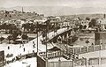
Ohrid is a city in North Macedonia and is the seat of the Ohrid Municipality. It is the largest city on Lake Ohrid and the eighth-largest city in the country, with the municipality recording a population of over 42,000 inhabitants as of 2002. Ohrid is known for once having 365 churches, one for each day of the year, and has been referred to as the "Jerusalem of the Balkans". The city is rich in picturesque houses and monuments, and tourism is predominant. It is located southwest of Skopje, west of Resen and Bitola. In 1979 and in 1980, respectively, Ohrid and Lake Ohrid were accepted as Cultural and Natural World Heritage Sites by UNESCO. Ohrid is one of only 28 sites that are part of UNESCO's World Heritage that are Cultural as well as Natural sites.

The Albanians in North Macedonia are the second largest ethnic group in North Macedonia, forming 446,245 individuals or 24.3% of the resident population. Of the 2,097,319 total population in the 2021 census, 619,187 or 29.52% are Albanians.

<span class="mw-page-title-main">Manaki brothers</span> Aromanian cinema pioneers (c. 1880- c. 1960)

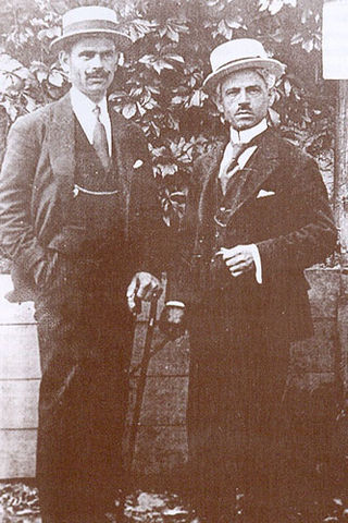
The Manaki brothers, Yanaki and Milton, were two Aromanian photography and cinema pioneers within the Balkan Peninsula and the Ottoman Empire. They were the first to bring a film camera and create a motion picture in the city of Manastir, an economic and cultural center of Ottoman Rumelia. Their first film, The Weavers, was a 60-second documentary of their grandmother spinning and weaving; this is regarded as the first motion picture shot in the Balkans. The Manaki brothers used a 35 mm Urban Bioscope camera that Yanaki imported from London in 1905. Yanaki and Milton filmed documentaries about various aspects of life in the city of Manastir.

<span class="mw-page-title-main">Kosovo vilayet</span> Administrative division (vilayet) of the Ottoman Empire from 1877 to 1913

The Vilayet of Kosovo was a first-level administrative division (vilayet) of the Ottoman Empire in the Balkan Peninsula which included the current territory of Kosovo and the north-western part of the Republic of North Macedonia. The areas today comprising Sandžak (Raška) region of Serbia and Montenegro, although de jure under Ottoman control, were in fact under Austro-Hungarian occupation from 1878 until 1909, as provided under Article 25 of the Treaty of Berlin. Üsküb (Skopje) functioned as the capital of the province and the midway point between Istanbul and its European provinces. Üsküb's population of 32,000 made it the largest city in the province, followed by Prizren, also numbering at 30,000.

<span class="mw-page-title-main">Adrianople vilayet</span> First-level administrative division of the Ottoman Empire

The Vilayet of Adrianople or Vilayet of Edirne was a first-level administrative division (vilayet) of the Ottoman Empire.

<span class="mw-page-title-main">Manastir vilayet</span> Ottoman province

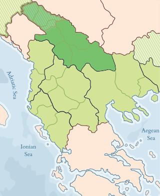
The Vilayet of Manastir was a first-level administrative division (vilayet) of the Ottoman Empire, created in 1874, dissolved in 1877 and re-established in 1879. The vilayet was occupied during the First Balkan War in 1912 and divided between the Kingdom of Greece and the Kingdom of Serbia, with some parts later becoming part of the newly established Principality of Albania.

<span class="mw-page-title-main">Serbs in North Macedonia</span> Ethnic group in North Macedonia

The Serbs are one of the constitutional ethnic groups of North Macedonia, numbering about 24,000 inhabitants.

<span class="mw-page-title-main">Lordship of Prilep</span> Medieval lordship in the Balkans

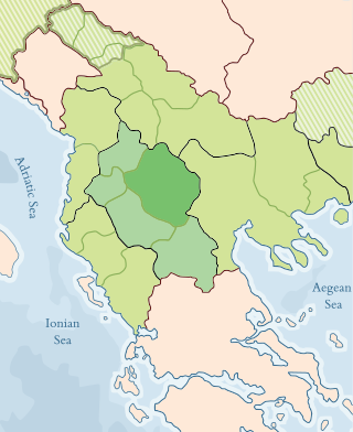
The Lordship of Prilep, also known as the Realm of King Marko or the Kingdom of Prilep, was one of the successor-states of the Serbian Empire, covering mainly the southern regions of the former empire, corresponding to western parts of present-day North Macedonia. Its central region of Pelagonia, with the city of Prilep, was held by lord Vukašin Mrnjavčević, who in 1365 became Serbian king and co-ruler of Serbian emperor Stefan Uroš V (1355–1371). After king Vukašin died at the Battle of Maritsa in 1371, the realm was obtained by his son and designated successor Marko Mrnjavčević, who took the title of Serbian king. At that time, capital cities of the Serbian realm were Skopje and Prizren, but during the following years king Marko lost effective control over those regions, and moved his residence to Prilep. He ruled there until his death in the Battle of Rovine in 1395. By the end of the same year, the Realm of late King Marko was conquered by the Ottoman Empire.

<span class="mw-page-title-main">Rumelia Eyalet</span> 1365–1867 Ottoman province in the Balkans

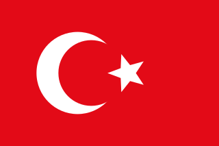
The Eyalet of Rumeli, or Eyalet ofRumelia, known as the Beylerbeylik of Rumeli until 1591, was a first-level province of the Ottoman Empire encompassing most of the Balkans ("Rumelia"). For most of its history, it was the largest and most important province of the Empire, containing key cities such as Edirne, Yanina (Ioannina), Sofia, Filibe (Plovdiv), Manastır/Monastir (Bitola), Üsküp (Skopje), and the major seaport of Selânik/Salonica (Thessaloniki). It was also among the oldest Ottoman eyalets, lasting more than 500 years with several territorial restructurings over the long course of its existence.

<span class="mw-page-title-main">Sanjak of Dibra</span> Administrative unit of the Ottoman Empire from 1395 to 1913 in present-day Albania & North Macedonia

The Sanjak of Dibra, Debar, or Dibër was one of the sanjaks of the Ottoman Empire. Its capital was Debar, Macedonia. Today, the western part of its territory belongs to Albania and the eastern part to North Macedonia.

<span class="mw-page-title-main">Sanjak of Prizren</span> Sanjak of the Ottoman Empire from 1455 to 1913

The Sanjak of Prizren was one of the sanjaks in the Ottoman Empire with Prizren as its administrative centre. It was founded immediately after Ottoman Empire captured Prizren from Serbian Despotate in 1455. The rest of the territory of Serbian Despotate was conquered after the fall of Smederevo in 1459, and divided into following sanjaks: Sanjak of Viçitrina, Sanjak of Kruševac and Sanjak of Smederevo. At the beginning of the First Balkan War in 1912, the territory of Sanjak of Prizren was occupied by the army of the Kingdom of Serbia. Based on Treaty of London signed on 30 May 1913, the territory of Sanjak of Prizren became part of Serbia.

<span class="mw-page-title-main">Sanjak of Üsküp</span> Administrative unit of the Ottoman Empire from 1463 to 1913

The Sanjak of Üsküp was one of the sanjaks in the Ottoman Empire, with Üsküb as its administrative centre.

<span class="mw-page-title-main">Sanjak of Elbasan</span>

The Sanjak of Elbasan was one of the sanjaks of the Ottoman Empire. Its county town was Elbasan in Albania.

<span class="mw-page-title-main">Sanjak of Ohrid</span> 1395–1864 Ottoman administrative unit

The Sanjak of Ohri was one of the sanjaks of the Ottoman Empire established in 1395. Part of it was located on the territory of the Lordship of Prilep, a realm in Macedonia ruled by the Ottoman vassal Prince Marko until his death in the Battle of Rovine.

The Sanjak of Viçitrina, also known as the Pristina Pashaluk, was a sanjak of the Ottoman Empire in Rumelia, in present-day Kosovo. It was named after its administrative center Vučitrn.

The Sanjak of Sofia was one of the sanjaks of the Ottoman Empire which county town was Sofia. It was founded in 1393 and disestablished after the creation of the Principality of Bulgaria in 1878.

The following is a timeline of the history of the city of Skopje, North Macedonia.

<span class="mw-page-title-main">Jovan Ćirković</span>

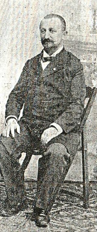
Jovan Ćirković, known as Čifa (Чифа) or Ćirko-paša (Ћирко-паша), was a Serbian teacher, revolutionary (Chetnik) during the Macedonian Struggle, and politician.

<span class="mw-page-title-main">Sanjak of Monastir</span>

The Sanjak of Monastir or Manastir or Bitola, was a sanjak within the Rumelia Eyalet (1465–1867) and then the Manastir Vilayet (1874–1912). The administrative seat was in Manastir (Bitola).

References

  1. 1 2 Encyclopædia Britannica – Rumelia at Encyclopædia Britannica.com
  2. Sedlar, Jean W., East Central Europe in the Middle Ages, 1000-1500, (University of Washington Press, 1994), 385.
  3. The last centuries of Byzantium, (1261-1453) by Donald MacGillivray Nicol
  4. Stojanovski, Aleksandar (1989), Makedonija vo turskoto srednovekovie : od krajot na XIV--početokot na XVIII vek (in Macedonian), Skopje: Kultura, p. 49, OCLC   21875410 , retrieved 24 December 2011, ОХРИДСКИ САНЏАК (Liva i Ohri): Овој санџак исто така е еден од најстарите санџаци во Румелискиот беглербеглак. Се смета дека бил создаден по загинувањето на крал Марко (1395),..
  5. Šabanović, Hazim (1959), Bosanski pašaluk : postanak i upravna podjela (in Croatian), Sarajevo: Oslobođenje, p. 20, OCLC   10236383 , retrieved 26 December 2011, Poslije pogibije kralja Marka i Konstantina Dejanovića na Rovinama (1394) pretvorene su njihove oblasti u turske sandžake, Ćustelndilski i Ohridski.
  6. "Macedonia :: The Ottoman Empire". Britannica. 2010. Retrieved August 25, 2010.
  7. "A brief account of the history of Skopje". skopje.mk. 2010. Archived from the original on February 25, 2009. Retrieved August 25, 2010. A monk at the Saint Theodor Monastery on Mt. Vodno briefly recorded the date of the town's capture by the Turks: "In the 69th year (1392) the Turks took Skopje on the 6th day of the month (January 19, 1392 according to the new calendar).
  8. Marinus Barletius: Historia de vita et gestis Scanderbegi Epirotarum principis
  9. Ursinus, M. (1991). "Manāstir". The Encyclopedia of Islam, New Edition, Volume VI: Mahk–Mid. Leiden and New York: BRILL. pp. 371–372. ISBN   90-04-08112-7.
  10. Birken, Andreas (1976). Die Provinzen des Osmanischen Reiches. Beihefte zum Tübinger Atlas des Vorderen Orients (in German). Vol. 13. Reichert. pp. 50, 52. ISBN   9783920153568.
  11. Viquesnel, Auguste (1868). Voyage dans la Turquie d'Europe: description physique et géologique de la Thrace (in French). Vol. Tome Premier. Paris: Arthus Betrand. pp. 107, 114–115.
  12. 1 2 Karpat, K.H. (1985). Ottoman population, 1830-1914: demographic and social characteristics. Madison, Wis: University of Wisconsin Pres. p. 134-135, 140-141, 144-145.
  13. "Balkan Wars". Britannica. Retrieved August 27, 2010.
  14. "The Church of St Spas - Skopje". National Tourism Portal of Macedonia. July 2005. Archived from the original on May 27, 2011. Retrieved August 27, 2010. ...half of it was constructed underground, due to the 17th century edict of the Turkish Sultan that prohibited Christian structures from being higher than mosques.
  15. "The Sixteenth Century Mosques of Bitola / Toli Manastır1" (PDF). Kalamus. c. 2010. Retrieved August 27, 2010.