North Malvern

Last updated

North Malvern
North Malvern - geograph.org.uk - 247013.jpg
North Malvern from End Hill.
OS grid reference SO7747
Civil parish
  • Malvern
District
Shire county
Region
Country England
Sovereign state United Kingdom
Post town MALVERN
Postcode district WR14
Police West Mercia
Fire Hereford and Worcester
Ambulance West Midlands
UK Parliament
  • West Worcestershire
List of places
UK
England
Worcestershire

North Malvern is a suburb of Malvern, Worcestershire, England. It nestles on the northern slopes of the Malvern Hills. It is a contiguous urban extension of Link Top, and other neighbouring centres of population are Great Malvern, Malvern Link, West Malvern and the former village of Cowleigh. It is part of the civil parish of Malvern, administered by the Malvern Hills District, and is included in the informal region known as The Malverns.

Contents

Architecture

Historic buildings include the Clock Tower near Tank Quarry, with its modern work of art the Cascade Gates (2007) in welded steel, by artist and sculptor Rose Garrard, the 18th century North Malvern House (formerly a public house now flats) and the Victorian building of the former North Malvern school.

Religious buildings in the North Malvern area include: Holy Trinity Church (CofE), [1] St. Peters church (CoE) and St. Joseph's (RC). [2] Above North Malvern lie the now defunct quarries of Tank Quarry, North Quarry, and Scar Quarry that were a major feature of local industry until about 1960. The dynamite detonations and the accompanying rock fall that could be heard for miles around were a familiar sound backdrop in the area. [3]

Education

Northleigh primary school is a Church of England (CofE) voluntary aided school. [4]

Notable people

Haile Selassie, Emperor of Ethiopia, lived in Malvern for a while after being forced out of Ethiopia by the Italian invasion in the late 1930s. During this time he attended services at Holy Trinity Church in Link Top and his granddaughters and daughters of court officials were educated at Clarendon School for Girls in North Malvern. [5] [6]

The Clock Tower, North Malvern. The Clock Tower - 2 - geograph.org.uk - 906497.jpg
The Clock Tower, North Malvern.
The Cascade Gates (2007) by Rose Garrard, at the Clock Tower, North Malvern. Door to well room, Clock Tower, North Malvern - geograph.org.uk - 975354.jpg
The Cascade Gates (2007) by Rose Garrard, at the Clock Tower, North Malvern.

North Malvern in cultural life

The Tank Quarry on North Hill was used as a location in the Doctor Who serial The Krotons , which was broadcast in four weekly parts from 28 December 1968 to 18 January 1969. [7]

View from North Malvern, looking to the North View to North of Malvern.jpg
View from North Malvern, looking to the North

Transport

Rail

North Malvern is served by two stations about one mile apart on the same line. The Great Malvern railway station is located in Avenue Road, Malvern and Malvern Link railway station on the Worcester Road. Direct services are provided to Worcester, Hereford, Birmingham, Oxford and London.

Bus

Local bus services connect North malvern with the surrounding area including the 42, S42 circular local routes. Serving areas further afield are: the Malvern to Worcester route 44, 44A, 44B operated by First Diamond serving stops at the Barnards Green bus shelter and Pound Bank; The Worcester - Upton-upon-Severn - Malvern route 362/363 operated by Diamond serves that stops at the Barnards Green bus shelter and the Malvern - Gloucester - Cheltenham route 377 (Saturdays only) operated by Diamond, stopping at the Court Road shops and the Barnards Green bus shelter.

Air

The nearest major airport is Birmingham approximately one hour by road via the M5 and M42 motorways. Gloucestershire Airport located at Staverton, in the Borough of Tewkesbury near Malvern is a busy General Aviation airport used mainly for private charter and scheduled flights to destinations such as the islands of Jersey, Guernsey, and the Isle of Man, pilot training, and by the aircraft of emergency services.

Related Research Articles

<span class="mw-page-title-main">Malvern Hills</span> Hills in central England

The Malvern Hills are in the English counties of Worcestershire, Herefordshire and a small area of northern Gloucestershire, dominating the surrounding countryside and the towns and villages of the district of Malvern. The highest summit affords a panorama of the Severn Valley, the hills of Herefordshire and the Welsh mountains, parts of thirteen counties, the Bristol Channel, and the cathedrals of Worcester, Gloucester and Hereford.

<span class="mw-page-title-main">Malvern, Worcestershire</span> Spa town and civil parish in Worcestershire, England

Malvern is a spa town and civil parish in Worcestershire, England. It lies at the foot of the Malvern Hills, a designated Area of Outstanding Natural Beauty. The centre of Malvern, Great Malvern, is a historic conservation area, which grew dramatically in Victorian times due to the natural mineral water springs in the vicinity, including Malvern Water.

<span class="mw-page-title-main">Upton-upon-Severn</span> Human settlement in England

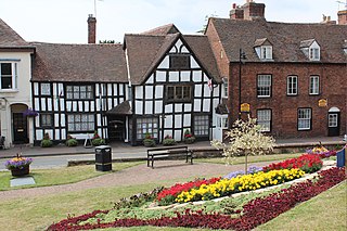
Upton-upon-Severn is a town and civil parish in the Malvern Hills District of Worcestershire, England. Lying on the A4104, the 2021 census recorded a population of 2,903 for the town.

<span class="mw-page-title-main">Great Malvern</span> Human settlement in England

Great Malvern is an area of the civil parish of Malvern, in the Malvern Hills district, in the county of Worcestershire, England. It lies at the foot of the Malvern Hills, a designated Area of Outstanding Natural Beauty, on the eastern flanks of the Worcestershire Beacon and North Hill, and is the historic centre of Malvern and includes its town centre.

<span class="mw-page-title-main">Malvern Wells</span> Human settlement in England

Malvern Wells is a village and civil parish south of Great Malvern in the Malvern Hills district of Worcestershire, England. The parish, once known as South Malvern, was formed in 1894 from parts of the civil parishes of Hanley Castle, Welland, and the former parish of Great Malvern, and owes its development to the 19th-century boom years of Malvern as a spa town. Malvern Wells is a centre of commercial bottling of Malvern water. The population of the parishes of Malvern Wells and Little Malvern was recorded in 2011 as 3,196.

<span class="mw-page-title-main">Malvern Link</span> Human settlement in England

Malvern Link is an area of Malvern, Worcestershire, England to the north and east of Great Malvern. The centres of Malvern Link and Great Malvern are separated by Link Common, an area of open land that is statutorily protected by the Malvern Hills Conservators. In 1900 Malvern Link Urban District, which had been formed only five years earlier, merged with Great Malvern to become Malvern Town. The population of Link in 2011 was 6,155.

<span class="mw-page-title-main">Barnards Green</span> Human settlement in England

Barnards Green is one of the main population areas of Malvern, Worcestershire, England, situated approximately 1 mile (1.6 km) east and downhill from Great Malvern, the town's traditional centre.

<span class="mw-page-title-main">Cockfield, County Durham</span> Village in County Durham, England

Cockfield is a village on the edge of Teesdale, County Durham, England. It is situated 8 miles to the south-west of Bishop Auckland, 15 miles (24 km) north-west of Darlington and 40 miles (64 km) south-west of Newcastle upon Tyne. Remains found on Cockfield Fell suggest there was a settlement in the area during the Iron Age. The parish church, dedicated to St Mary the Virgin, probably dates from the late 12th century.

<span class="mw-page-title-main">Worcestershire Beacon</span>

Worcestershire Beacon, also popularly known as Worcester Beacon, or locally simply as The Beacon, is a hill whose summit at 425 metres (1,394 ft) is the highest point in Worcestershire. It is part of the Malvern Hills which run about 13 kilometres (8.1 mi) north-south along the Herefordshire-Worcestershire border.

<span class="mw-page-title-main">Euxton</span> Human settlement in England

Euxton is a village and civil parish of the Borough of Chorley, in Lancashire, England. The population of the civil parish as taken at the 2011 census was 9,993, however, the population is now estimated to be around 14,000 due to the increase in housing developments in the village, including the Buckshaw development. The village is situated just to the west of Chorley, and to the south of Clayton-le-Woods.

<span class="mw-page-title-main">Newland, Worcestershire</span> Village located in Malvern Hills, England

Newland is a village and civil parish on the north-eastern edge of Malvern Link, Worcestershire, England, on the A449 road.

<span class="mw-page-title-main">Great Malvern railway station</span> Railway station in Worcestershire, England

Great Malvern railway station is one of two stations serving the town of Malvern, Worcestershire, England on the Hereford to Worcester section of the Cotswold Line. It is situated downhill from the centre of Great Malvern and close to Barnards Green. The station retains most of its original Victorian station design by the architect Edmund Wallace Elmslie and is a Grade II listed building.

<span class="mw-page-title-main">Hartlebury Common</span> Lowland heath in Worcestershire, England

Hartlebury Common is an area of lowland heath in north Worcestershire, England, situated just outside the town of Stourport-on-Severn. Hartlebury Common and Hillditch Coppice are a biological and geological Site of Special Scientific Interest which covers an area of 90.2 hectares . The common supports many varieties of wild plants and insects, especially butterflies and moths. Hartlebury Common and Hillditch Pool are a Local Nature Reserve.

<span class="mw-page-title-main">Dyson Perrins Church of England Academy</span> Academy school in Malvern, Worcestershire, England

Dyson Perrins CofE Academy is a co-educational secondary school in Malvern, Worcestershire, England. It is named after its benefactor Charles William Dyson Perrins, heir to the Lea & Perrins Worcestershire sauce company. It is located near Malvern Link, a northern suburb of the town of Malvern, Worcestershire.

<span class="mw-page-title-main">Ronkswood</span> Human settlement in England

Ronkswood is a suburb of the city of Worcester, the county seat of Worcestershire, England. It is around one mile east of the city centre, centred on Newtown Road (B4636). Much of the Ronkswood housing estate was built in the late 1940s.

<span class="mw-page-title-main">Poolbrook</span> Human settlement in England

Poolbrook is a village and a suburb of Malvern, Worcestershire, England, situated approximately 1.5 miles (2.4 km) southeast of Great Malvern, the town's centre, and about 0.5 miles (08 km) from the Malvern suburb of Barnards Green on the Poolbrook Road (B4208). The village comprises several shops, a traditional English pub, and a number of council and private housing estates. St Andrew's C of E parish church was built in Early English style in 1882 as a memorial to a member of the Chance Brothers glass manufacturing family. The village occupies the geographical centre of the Chase ward of Malvern Town Council.

<span class="mw-page-title-main">Link Top</span> Human settlement in England

Link Top is a locality of Malvern Link, a major population area of the town of Malvern, Worcestershire, England. It is situated at the western extremity of Malvern Link at its boundary with Great Malvern and North Malvern. It is centred on a sharp left hand bend in the Worcester Road (A449) that forms a complex junction with the North Malvern Road, Hornyold Road, Newtown Road, and Lygon Bank,

<span class="mw-page-title-main">Worcestershire bus route 144</span> Bus route in Worcestershire, England

Worcestershire bus route 144 is a bus service connecting the Worcestershire areas of Catshill, Bromsgrove. Droitwich and Worcester, operated by First Worcestershire. The service dates back to 1914 and was one of the longest-running double-deck bus operated routes, though it is now more common for single decked buses to be used.

<span class="mw-page-title-main">Sherrard's Green</span> Human settlement in England

Sherrard's Green is a village and a suburb of Malvern, Worcestershire, England, situated approximately 1.5 miles southeast of Great Malvern, the town's centre, and about 0.5 miles (0.80 km) from the Malvern suburb of Barnards Green. The village comprises a number of council and private housing estates and the small parish church of St Mary's, Pickersleigh, and a Tesco convenience store that opened in 2011 on the site of a former pub, The New Gas Tavern.

References

  1. Holy Trinity Church Retrieved April 2006
  2. St Joseph Catholic Church 7 February 2010
  3. North Malvern quarries Retrieved 7 February 2010
  4. "School Profile - Northleigh CofE Primary School". DirectGov. 10 January 2011. Archived from the original on 15 May 2012. Retrieved 27 June 2011.
  5. "Emperor's life in town is recalled in BBC film". Malvern Gazette. Newsquest Media Group. 14 February 2003. Retrieved 27 June 2011.
  6. "'Princesses were my school chums'". Malvern Gazette. Newsquest Media Group. 5 May 2006. Retrieved 27 June 2011.
  7. "Tank Quarry". Dr Who – The Locations Guide. Retrieved 27 June 2011.

52°07′15″N2°20′14″W / 52.12083°N 2.33734°W / 52.12083; -2.33734