
Richmond Heights is a city in St. Louis County, Missouri. It is an inner-ring suburb of St. Louis, Missouri, United States. The population was 8,603 at the 2010 census. According to Robert L. Ramsay, the name was suggested by Robert E. Lee, who thought the topography of the area resembled Richmond, Virginia.

Benton Park West is a neighborhood located in South St. Louis City, Missouri, United States. The neighborhood is bounded by Jefferson Ave. on the east, Gravois Ave. on the north and west, and an irregular boundary consisting of Cherokee Street, S. Compton Ave., and Potomac St. to the south. The neighborhood is the conglomeration of two different neighborhoods in the 1970s, Compton Hill and Marquette-Cherokee. Parts of these two 1970s neighborhoods make up the current day Benton Park West. Marquette-Cherokee was bounded by Arsenal Street on the north, Bates Street on the south and Grand Boulevard on the west. Its eastern edge was the bank of the Mississippi River. Benton Park West has the highest percentage of Latino residents among St. Louis neighborhoods.

Clifton Heights is a neighborhood of St. Louis, Missouri, US, located along the southwest border of the city and highlighted by a park — Clifton Park (38.6143°N 90.2916°W) — with a playground and a lake.

North Point is a neighborhood of St. Louis, Missouri, US. It is bounded by Goodfellow on the North, Northcrest, West Florissant on the Southwest, and Riverview Boulevard on the East and Northeast.
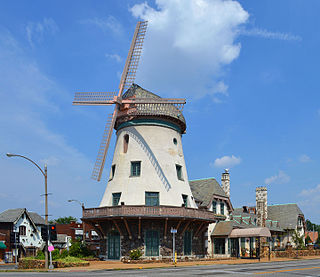
Bevo Mill is a neighborhood located in south St. Louis, Missouri.

Carr Square is a neighborhood of St. Louis, Missouri. The Downtown neighborhood is bounded by Cass Avenue on the North, Carr Street on the South, North Tucker Boulevard and North 13th Street on the East, and North Jefferson on the West.

Columbus Square is a neighborhood of St. Louis, Missouri. It is bounded by Cass Avenue to the north, I-70 to the east, Tucker & North 13th Streets to the west, and Cole Street to the south.
Fairground is a neighborhood of St. Louis, Missouri. The neighborhood's boundaries are defined as Glasgow Avenue on the east, west and North Florissant Avenues on the north, Warne on the west, and Fairground Park and Natural Bridge Avenue on the south.

Fox Park is a neighborhood of St. Louis, Missouri. The neighborhood borders are Jefferson Avenue to the east, Interstate 44 to the north, Gravois Avenue to the south and Nebraska Avenue to the west. Surrounding neighborhoods include the Gate District, Compton Heights, Tower Grove East, Benton Park West and McKinley Heights.
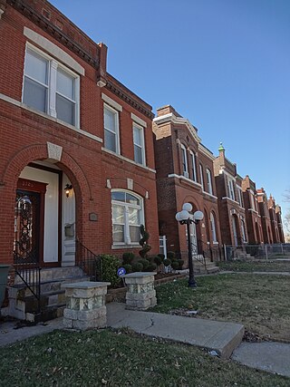
Gravois Park is a historic neighborhood of St. Louis, Missouri. Roughly bounded by Jefferson Avenue, Chippewa Street, Grand Boulevard, and Cherokee Street, the Gravois Park neighborhood is a diverse mix of homeowners, renters, and businesses. The area's architecture reflects its settlement at the turn of the 20th century. The namesake park dates from 1812, and was praised for its beauty in the nineteenth century already, and in 1914 was part of a walking tour of the city meant to show off the City Plan Commission's "idealized view of the shape of the city."

The Greater Ville is a neighborhood of St. Louis, Missouri. The area is bounded by Marcus Avenue on the northwest, Natural Bridge Avenue on the northeast, Dr. Martin Luther King Drive and St. Louis Avenue on the south via North Taylor Avenue and Sarah Street, and North Vandeventer Avenue on the southeast. The Greater Ville surrounds The Ville neighborhood.

Hyde Park is a neighborhood of St. Louis, Missouri. A historic North St. Louis neighborhood, Hyde Park is bound by Ferry to the North, I-70 to the East, Palm Street and Natural Bridge Avenue to the South, and Glasgow to the West.

St. Louis Hills is a neighborhood in St. Louis, Missouri. The neighborhood, which is home to the Chippewa location of Ted Drewes Frozen Custard, is situated in the southwest part of St. Louis. It is bounded by Chippewa Street to the northwest and north, Hampton Avenue to the east, Gravois Avenue to the southeast, and the St. Louis county border to the southwest.

Lindenwood Park is a neighborhood of St. Louis, Missouri. The Lindenwood Neighborhood is defined by Arsenal Street and I-44 to the north, Watson and Chippewa Street to the south, Hampton Avenue on the east and the city limits to the west.
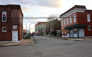
Marine Villa is a neighborhood of St. Louis, Missouri. The neighborhood is located just south of the large and historic Anheuser-Busch Brewery complex along the bluffs of the Mississippi River. It is further defined by Cherokee Street's Antique Row on the north, Gasconade Street on the south, South Broadway and Jefferson Avenue on the west, and the Mississippi River on the east.

Mark Twain/I-70 Industrial is a neighborhood of St. Louis, Missouri. It is bound by I-70 to the north, North Kingshighway to the east, Natural Bridge Road to the south, and the city limit to the west.

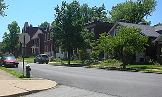
McKinley Heights is a historic conservation neighborhood located in the near South Side of the City of St. Louis. It was rated as a Top 10 Neighborhood for young adults in the St. Louis metropolitan area. The neighborhood is bounded by I-44 to the north, Jefferson Avenue to the west, and I-55 and Gravois Boulevard to the east and south. There are restaurants and entertainment in the adjacent Soulard and Lafayette Square neighborhoods. Three bus routes provide a commute downtown or throughout the City. There are three churches and several neighborhood businesses. There is also 1 6th-12th Grade High School, McKinley Classical Leadership Academy

North Hampton is a neighborhood of St. Louis, Missouri. Located in Southwest City, North Hampton is bounded by Scanlan and Connecticut to the north, South Kingshighway Boulevard to the east, Chippewa Street to the south, and Hampton Avenue to the west.

Near North Riverfront is a neighborhood of St. Louis, Missouri. Between 1990 and 2000 Near North Riverfront led the city in percentage population growth, growing 89% over the decade. Despite this large percentage growth, Near North Riverfront is largely non-residential and so the 89% percent gain represented a numerical gain of only 306 persons. The neighborhood is served by major city streets such as Tucker Boulevard, West Florissant Avenue, and Broadway Boulevard.

O'Fallon is a neighborhood of St. Louis, Missouri. The neighborhood is located on the north side of the City of St. Louis, nestled between O'Fallon Park and Fairground Park. It is bounded by West Florissant, Harris Avenue, Algernon Street and Adelaide on the north, Pope Avenue on the northwest, Kossuth and Natural Bridge Avenues on the south via Fair Avenue, Warne on the east, and Newstead on the west. The O'Fallon neighborhood is located in the 21st Ward which is currently represented by Alderman John Collins-Muhammad.

