
North Yorkshire is a ceremonial county in Northern England. It borders County Durham to the north, the North Sea to the east, the East Riding of Yorkshire to the south-east, South Yorkshire to the south, West Yorkshire to the south-west, and Cumbria and Lancashire to the west.

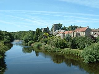
Ripon is a cathedral city in North Yorkshire, England. The city is located at the confluence of two tributaries of the River Ure, the Laver and Skell. Within the boundaries of the historic West Riding of Yorkshire, the city is noted for its main feature, Ripon Cathedral, which is architecturally significant, as well as the Ripon Racecourse and other features such as its market.

Masham is a market town and civil parish in North Yorkshire, England. It had a population of 1,205 at the 2011 census.
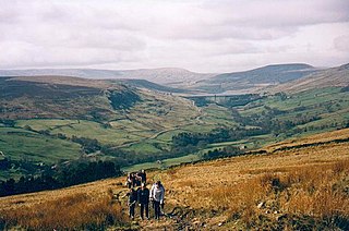
The Nidderdale AONB is an Area of Outstanding Natural Beauty in North Yorkshire, England, bordering the Yorkshire Dales National Park to the east and south. It comprises most of Nidderdale itself, part of lower Wharfedale, the Washburn valley and part of lower Wensleydale, including Jervaulx Abbey and the side valleys west of the River Ure. It covers a total area of 233 square miles (600 km2). The highest point in the Nidderdale AONB is Great Whernside, 704 metres (2,310 ft) above sea level, on the border with the Yorkshire Dales National Park.

Bishop Monkton is a village and civil parish in the Harrogate district of North Yorkshire, England, about five miles south of Ripon. According to the 2001 census it had a population of 775, increasing slightly to 778 at the 2011 Census. In 2015, North Yorkshire County Council estimated the population to be 760.

Bridge Hewick is a village and civil parish in the Harrogate district of North Yorkshire, England. The village is situated on the River Ure, and approximately 2 miles (3 km) east of the market town of Ripon. The population was recorded at less than 100 at the 2011 Census. Details are included on the statistics of the civil parish of Copt Hewick. North Yorkshire County Council estimate that the population at the 2011 census was 50, which had risen to 60 by 2015.

North Stainley is a village in the Harrogate district of North Yorkshire, England 4 miles (6.4 km) north of Ripon. Historically part of the West Riding of Yorkshire, it is the closest settlement to the theme park Lightwater Valley which is 0.62 miles (1 km) to the south.

High Ellington is a village in lower Wensleydale in North Yorkshire, England, about 2.5 miles (4 km) north-west of Masham. The smaller village of Low Ellington is 0.6 miles (0.97 km) to the east. High Ellington is in Harrogate district, and is the largest settlement in the civil parish of Ellington High and Low, which also includes Low Ellington and the scattered settlement of Sutton. The population of the parish was estimated at 60 in 2013.
West Tanfield is a village and civil parish in the Hambleton district of North Yorkshire, England. The village is situated approximately six miles north of Ripon on the A6108, which goes from Ripon to Masham and Wensleydale. The parish includes the hamlets of Nosterfield, Thornborough and Binsoe.

Wath is a village and civil parish 3.7 miles (6 km) north of Ripon in North Yorkshire, England. The population of the parish was estimated at 210 in 2015.

Thornborough is a village in Hambleton District of North Yorkshire, England. It is about 7 miles (11 km) south of Bedale and 3 miles (5 km) west of the A1(M) motorway. Thornborough is in the West Tanfield parish. The Thornborough Henges ancient monuments are situated south and west of the village. The village lies just to the south of the B6267 road, which connects the A6055 in the east, with the A6108 road at Masham. The village is served by two buses a day in each direction between Ripon and Masham. When the Masham Branch of the North Eastern Railway was open, Tanfield station would have been the nearest railway station to Thornborough. Now the nearest railway station is at Thirsk.

Hutton Conyers is a village and civil parish in the Harrogate district of North Yorkshire, England. It is situated near the River Ure and 1-mile (1.6 km) north-east of Ripon. The parish extends from the River Ure to the A1(M) motorway, and includes the village of Nunwick.

Milby is a hamlet and civil parish in the Harrogate district of North Yorkshire, England. It is situated to the immediate north of Boroughbridge.

Roecliffe is a village and civil parish in the Harrogate district of North Yorkshire, England. It is situated near the A1 road motorway which connects London with Edinburgh and is 1 mile west of Boroughbridge. It is on the banks of the River Ure and the village centres on the village green which doubles up as the school playing field.

Nunwick is a village in the Harrogate district of North Yorkshire, England. It is about 1 mile north-east of Ripon.
South Stainley is a small village in the Harrogate District, in the county of North Yorkshire, England. Nearby settlements include the city of Ripon, the town of Harrogate and the village of Markington. South Stainley is on the A61 road. South Stainley has a pub and a place of worship, St Wilfrid's Church, which is a grade II listed structure.

Markington is a village in the Harrogate district, in the English county of North Yorkshire. The population of the civil parish taken at the 2011 census was 629. Nearby settlements include the city of Ripon, the town of Harrogate, the village of South Stainley and the hamlet of Ingerthorpe. The A61 is nearby. Markington has a school, post office, village hall, cricket and football pitch, a church, a pub and a camp site.
Sutton Grange is a small settlement in North Yorkshire, England, 2 miles (3 km) north west of Ripon. It was historically a township in the parish of Ripon in the West Riding of Yorkshire, and became a separate civil parish in 1866. By 1961 the population of the parish was only 40. In 1974 it was transferred to Harrogate district in North Yorkshire, and in 1988 it was absorbed into the civil parish of North Stainley with Sleningford.

Mickley is a village in the Harrogate District of North Yorkshire, England. The village is on the south bank of the River Ure between Masham and West Tanfield.

Ripon Parks is a Site of Special Scientific Interest, or SSSI, situated north of Ripon, to the west of the River Ure and to the east of the village of North Stainley, in North Yorkshire, England. It was once part of the land held since the Middle Ages as a deer park by the archbishops of York and the canons of Ripon. The site was designated as an SSSI in 1983, because its varied habitats are valued for their breeding birds, amphibians and varied flora. The woods here are "of note" for the parasitic flowers of common toothwort and yellow star-of-Bethlehem. A small part of the site is accessible via public footpaths; there are no public facilities or dedicated car parks. The site incorporates the High Batts Nature Reserve, which is privately run for training, recording and educational purposes, and accessible to members only, except for its annual open day. Ripon Parks is now owned by the Ministry of Defence, and parts of the site are used as military training areas.

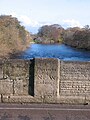 The bridge over the Ure at West Tanfield bears an inscription to mark the boundary between the West and North Ridings of Yorkshire.
 Sleningford Water Mill on the banks of the River Ure downstream from West Tanfield
