Related Research Articles

The Los Angeles River, historically known as Paayme Paxaayt'West River' by the Tongva and the Río Porciúncula'Porciúncula River' by the Spanish, is a major river in Los Angeles County, California. Its headwaters are in the Simi Hills and Santa Susana Mountains, and it flows nearly 51 miles (82 km) from Canoga Park through the San Fernando Valley, Downtown Los Angeles, and the Gateway Cities to its mouth in Long Beach, where it flows into San Pedro Bay. While the river was once free-flowing and frequently flooding, forming alluvial flood plains along its banks, it is currently notable for flowing through a concrete channel on a fixed course, which was built after a series of devastating floods in the early 20th century.
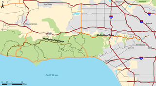
Mulholland Drive is a street and road in the eastern Santa Monica Mountains of Southern California. It is named after pioneering Los Angeles civil engineer William Mulholland. The western rural portion in Los Angeles and Ventura Counties is named Mulholland Highway. The road is featured in a significant number of films, songs, and novels. David Lynch, who wrote and directed a film named after Mulholland Drive, has said that one can feel "the history of Hollywood" on it. Jack Nicholson has lived on Mulholland Drive for many years, and still did so as of 2009.

Studio City is a neighborhood in the city of Los Angeles, California, in the southeast San Fernando Valley, just west of the Cahuenga Pass. It is named after the studio lot that was established in the area by film producer Mack Sennett in 1927, now known as Radford Studio Center.

The Sepulveda Dam is a dry dam constructed by the U.S. Army Corps of Engineers to withhold winter flood waters along the Los Angeles River. Completed in 1941, at a cost of $6,650,561, it is located south of center in the San Fernando Valley, approximately eight miles (13 km) east of the river's source in the western end of the Valley, in Los Angeles, California.

The Rio Hondo is a tributary of the Los Angeles River in Los Angeles County, California, approximately 16.4 miles (26.4 km) long. As a named river, it begins in Irwindale and flows southwest to its confluence in South Gate, passing through several cities. Above Irwindale its main stem is known as Santa Anita Creek, which extends another 10 miles (16 km) northwards into the San Gabriel Mountains where the source, or headwaters, of the river are found.

The Marvin Braude Bike Trail is a 22-mile (35 km) paved bicycle path that runs mostly along the shoreline of Santa Monica Bay in Los Angeles County, California. The coastal bike trail is widely acknowledged as Los Angeles’ “most popular bike path.”

The Arroyo Seco Bicycle Path is an approximately 2-mile (3.2 km) long Class I bicycle path along the Arroyo Seco river channel and canyon in the Northeast Los Angeles region of Los Angeles County, California. It parallels the Arroyo Seco Parkway, which is also a part of the canyon.
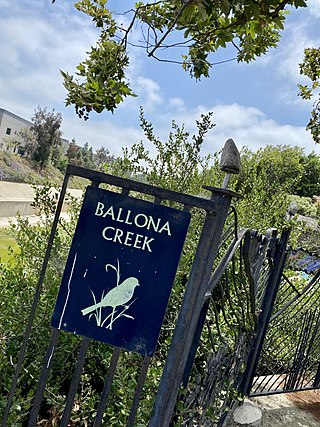
The Ballona Creek Bike Path is a 6.7-mile (10.8 km) Class I bicycle path and pedestrian route in California. The bike path follows the north bank of Ballona Creek until it reaches Santa Monica Bay at the Pacific Ocean. The route is defined by, and recognized for, the dramatic contrast between the channelized waterway’s stark cement geometry and the abundant wildlife of the verdant Ballona Wetlands.

Beverly Drive is a major north–south roadway in Beverly Hills and Los Angeles.

Valley Glen is a neighborhood in the southeastern section of the San Fernando Valley in Los Angeles, California. Once part of Van Nuys and North Hollywood, it became a separate neighborhood in 1998. Valley Glen is home to Los Angeles Valley College and the Great Wall of Los Angeles, a half-mile-long California-history mural listed on the National Register of Historic Places.

Coldwater Canyon is a canyon running perpendicular to and over the central Santa Monica Mountains, in Los Angeles County, California, United States.
Browns Canyon Wash, also known as Browns Canyon Creek, is a 10.3-mile-long (16.6 km) tributary of the Los Angeles River in the Santa Susana Mountains of Los Angeles County and across the western San Fernando Valley of Los Angeles, California.

The Los Angeles River bicycle path is a Class I bicycle and pedestrian path in the Greater Los Angeles area running from north to east along the Los Angeles River through Griffith Park in an area known as the Glendale Narrows. The 7.4 mile section of bikeway through the Glendale Narrows is known as the Elysian Valley Bicycle & Pedestrian Path. The bike path also runs from the city of Vernon to Long Beach, California. This section is referred to as LARIO, or more formally, the Los Angeles River Bikeway.

The Glendale Narrows is a scenic 11 mile section of the Los Angeles River in the Northeast Los Angeles region of Los Angeles County, California.

Owensmouth was a town founded in 1912 in the western part of the San Fernando Valley in Los Angeles County, California. Owensmouth joined the city of Los Angeles in 1917, and was renamed Canoga Park on March 1, 1931. Owensmouth was named for the 1913 Owens River aqueduct's terminus in current Canoga Park.

Coldwater Canyon Avenue is a street, primarily within the City of Los Angeles, in Los Angeles County, California. It runs 10.3 miles (16.6 km) from North Beverly Drive at Coldwater Canyon Park in Beverly Hills, north up Coldwater Canyon, including a short stretch shared with Mulholland Drive, ending at a crossroad intersection with Roscoe Boulevard in Sun Valley, where the Coldwater Canyon Avenue changes into Sheldon Street.

The Expo Bike Path is a 12-mile-long (19 km) rail with trail bicycle path and pedestrian route in Los Angeles County, California that travels roughly parallel to the Los Angeles Metro Rail's E Line between La Cienega/Jefferson and 17th Street/SMC stations. The Expo Bike Path is one of two major bicycle routes in Los Angeles that share dedicated rights-of-way with public transport, the other being the G Line Bikeway in the San Fernando Valley.

The Tujunga Wash Greenway and Bike Path is a trail and stormwater mitigation project in the Valley Village and Valley Glen neighborhoods of California’s San Fernando Valley.
References
- ↑ Kudler, Adrian Glick (2014-07-16). "A Map Guide to the Glorious Future of the Los Angeles River". Curbed LA. Retrieved 2022-08-14.
- ↑ Sanderson, Matthew (2013-10-08). "Workers Dig and Drill Along Future Valleyheart Riverwalk Greenway". Studio City, CA Patch. Retrieved 2022-08-14.
- 1 2 3 4 5 6 Pasillas, Andrew; Tran, Jimmy; Robertson, Cameron (2016-09-01). "Case Study No. 1". In Jessup, Kelsey; Callahan, Colleen; Burstein, Mara Elana; DeShazo, J.R. (eds.). Creating a Complete Los Angeles Greenway for All: Stories and Guidance (PDF). UCLA Luskin Center for Innovation. pp. 12–18.
- ↑ Hyperakt (2022-08-13). "North Valleyheart Riverwalk". On the Grid. Retrieved 2022-08-14.
- ↑ "Public Art Along The South Bank of the L.A. River in Studio City". KCET. 2011-03-30. Retrieved 2022-08-14.
- 1 2 3 Jao, Carron (2014-06-17). "North Valleyheart Riverwalk Greens the Way in Studio City". KCET. Retrieved 2022-08-14.
- ↑ "Greenway Trail in Studio City – Hit or Miss? - Going California" . Retrieved 2022-08-14.
- ↑ Chen, Anna (2013-09-11). "Go car free in Sherman Oaks and Studio City for International Car Free Day". The Source. Retrieved 2022-08-14.