Related Research Articles
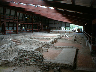
Lullingstone Roman Villa is a villa built during the Roman occupation of Britain, situated in Lullingstone near the village of Eynsford in Kent, south-eastern England. The villa is located in the Darent Valley, along with six others, including those at Crofton, Crayford and Dartford. Constructed in the 1st century, perhaps around 80–90 AD, the house was repeatedly expanded and occupied until it was destroyed by fire in the 4th or 5th century. The villa was occupied over various periods within the Romano-British period, but after its destruction, it is only thought to have been reoccupied during the medieval period. The occupants were most likely wealthy Romans or native Britons who had adopted Roman customs.

Berkhamsted is a historic market town in Hertfordshire, England, in the Bulbourne valley, 26 miles (42 km) north-west of London. The town is a civil parish with a town council within the borough of Dacorum which is based in the neighbouring large new town of Hemel Hempstead. Berkhamsted, along with the adjoining village of Northchurch, is encircled by countryside, much of it in the Chiltern Hills which is an Area of Outstanding Natural Beauty (AONB).

Hemel Hempstead is a town in the Dacorum district in Hertfordshire, England. It is 24 miles (39 km) northwest of London, and is part of the Greater London Urban Area. The population at the 2011 census was 97,500.

Dacorum is a local government district with borough status in Hertfordshire, England. The council is based in Hemel Hempstead. The borough also includes the towns of Berkhamsted and Tring and surrounding villages. The borough had a population of 155,081 in 2021. Dacorum was created in 1974 and is named after the ancient hundred of Dacorum which had covered a similar area. The borough of Dacorum is the westernmost of Hertfordshire's ten districts. It borders St Albans, Three Rivers, Buckinghamshire and Central Bedfordshire.
The Nickey line is a disused railway that once linked the towns of Hemel Hempstead and, initially, Luton but later Harpenden via Redbourn, in Hertfordshire, England. The course of most of the railway has been redeveloped as a cycle and walking path, and is part of the Oxford to Welwyn Garden City route of the National Cycle Network. It is approximately nine miles (14 km) long.

Hemel Hempstead railway station is on the West Coast Main Line, on the western edge of the town of Hemel Hempstead, Hertfordshire, England. The station is 24+1⁄2 miles (39.4 km) north-west of London Euston on the West Coast Main Line. Hemel Hempstead is managed by London Northwestern Railway and all train services are operated by London Northwestern Railway and Southern.

The River Bulbourne is a small river in Dacorum, Hertfordshire, England. The word bourne derives from the Anglo-Saxon word for a stream. It is an unnavigable tributary of the River Gade, which flows into the River Colne, which in turn is a tributary of the River Thames. The Bulbourne is an example of a chalk stream, which is a watercourse that flows from chalk-fed groundwater. Chalk streams are a very rare habitat globally, with more than 85% of all the 210 chalk streams in the world are found in England. The river is reduced in size, due to human activity, the main one being the building of the London to Birmingham Grand Union Canal through the narrow valley which takes most of the river's water.
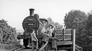
Heath Park Halt was a railway station in Hemel Hempstead, Hertfordshire in England, UK. It was the terminus for passenger services on the Nickey line, a 9-mile (14 km) branch line which ran from Harpenden into Hemel Hempstead town centre. Passenger services were withdrawn in 1947, and the line through the station was closed completely in 1959.

Boxmoor is part of Hemel Hempstead in Hertfordshire. It is within the district of Dacorum and comprises mainly 19th-century housing and meadowland, with transport links from London to the Midlands. At the 2011 Census, the population of Boxmoor was included in the Dacorum ward of Bovingdon, Flaunden and Chipperfield.

Gadebridge Roman Villa, alternatively known as Gadebridge Park Roman Villa, is a ruined Roman villa in Hemel Hempstead, Hertfordshire, England.
Bignor Roman Villa is a large Roman courtyard villa which has been excavated and put on public display on the Bignor estate in the English county of West Sussex. It is well known for its high quality mosaic floors, which are some of the most complete and intricate in the country.
Petuaria was originally a Roman fort situated where the town of Brough in the East Riding of Yorkshire now stands. Petuaria means something like 'quarter' or 'fourth part', incorporating the archaic Brythonic *petuar, 'four'.
This article gives brief information on schools that cater for pupils up to the age of 11 in the Dacorum district of Hertfordshire, England. Most are county maintained primary schools, sometimes known as "junior mixed infant" (JMI). A small number are voluntary aided church schools or independent (fee-paying). The Local Education Authority is Hertfordshire County Council.

Cow Roast is a hamlet within the civil parishes of Northchurch and Wigginton in Hertfordshire, England. It is between Tring and Berkhamsted, along the A4251, adjacent to the Grand Union Canal and the West Coast Main Line. Today it comprises a row of 20th-century houses and a marina, together with several older properties including a public house. There are three car dealerships and a petrol station beside the main road.
Dacorum Heritage (DH) is a local history advocacy group in the United Kingdom. It collects and records the history of the Borough of Dacorum, Hertfordshire, in the south of England, and aims to encourage the appreciation of the heritage of Dacorum.

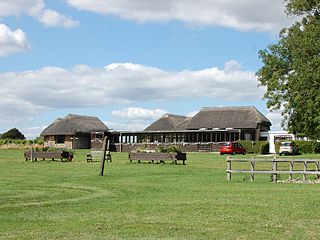
Boxmoor Roman Villa is a ruined Roman Villa at Boxmoor, Hemel Hempstead, Hertfordshire. The remains have been excavated, but they are now buried. The Roman villa was occupied from the first century AD up to the Fourth century.
Lockleys Roman Villa is a ruined Roman villa on the Lockleys estate near Welwyn, Hertfordshire. The site was excavated in 1937. This is one of two known villas near Welwyn, the other being Dicket Mead.
At Eccles in Kent the remains of a huge Roman Villa with palatial dimensions were excavated between 1962 and 1976. In the second century AD, the villa was almost 112 m long. Over 135 different rooms have been identified throughout the various periods of construction and reconstruction. The villa was abandoned in the Fourth century and much of it was removed in the Thirteenth century for the construction of Aylesford Priory.
Brantingham Roman villa is a Roman villa, now a scheduled monument, near Brantingham, East Riding of Yorkshire, England.
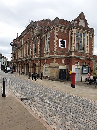
The Old Town Hall is a municipal building in the High Street, Hemel Hempstead, Hertfordshire, England. The town hall, which was the meeting place of Hemel Hempstead Borough Council, is a Grade II listed building.
References
- ↑ Neal: Northchurch, Boxmoor, and Hemel Hempstead Station, 6
- ↑ Neal: Northchurch, Boxmoor, and Hemel Hempstead Station, 6-11
- ↑ Neal: Northchurch, Boxmoor, and Hemel Hempstead Station, 29-30
- ↑ Neal: Northchurch, Boxmoor, and Hemel Hempstead Station, 13-16
- ↑ Neal, Coshː Roman Mosaics of Britain, Volume III, p. 306
- ↑ Alison Gebbels. inː Neal: Northchurch, Boxmoor, and Hemel Hempstead Station, 48