Northern New Guinea montane rain forests

Last updated
Northern New Guinea montane rain forests
Cagar Alam Cyclops dengan sebuah telaga kecil.jpeg
Ecoregion AA0116.png
Ecoregion territory (in purple)
Ecology
Realm Australasian realm
Biome tropical and subtropical moist broadleaf forests
Borders Northern New Guinea lowland rain and freshwater swamp forests
Geography
Area23,171 km2 (8,946 sq mi)
Countries
Provinces
Coordinates 2°30′S138°18′E / 2.5°S 138.3°E / -2.5; 138.3 Coordinates: 2°30′S138°18′E / 2.5°S 138.3°E / -2.5; 138.3
Conservation
Conservation status Critical/endangered
Protected3,374 km² (15%) [1]

The Northern New Guinea montane rain forests is a tropical moist forest ecoregion in northern New Guinea. The ecoregion covers several separate mountain ranges lying north of New Guinea's Central Range and south of the Pacific Ocean. [2] [3] [4]

Contents

Geography

The ecoregion includes the montane forests above 1000 meters elevation in the Van Rees Mountains, Foya Mountains, Cyclops Mountains, Bewani Mountains, Torricelli Mountains, Prince Alexander Mountains, and Adelbert Mountains. These isolated mountain ranges rise from the northern New Guinea lowlands, running generally east–west and between the Central Range and the sea. The northern New Guinea mountains are not as high as the Central Range; the Van Rees mountains reach to 1,430 m (4,690 ft), Foya to 2,193 m (7,195 ft), the Cyclops to 2,158 m (7,080 ft), the Bewani to 2,000 m (6,600 ft), the Torricelli to 1,650 m (5,410 ft), the Prince Alexander to 1,240 m (4,070 ft), and the Adelbert Mountains to 1,718 m (5,636 ft).[ citation needed ]

The montane forests are surrounded by Northern New Guinea lowland rain and freshwater swamp forests at lower elevations but differ from the lowland forests in form and species composition. [5]

Climate

The ecoregion has a montane tropical rain forest climate.

Flora

Montane tropical rain forests cover most of the ecoregion. The montane forests generally have a lower canopy than the lowland rain forests. Trees have smaller crowns, smaller glossy green leaves, and lack buttress roots. Common canopy trees include species of Nothofagus , Lithocarpus, Castanopsis, Syzygium , and Ilex , the families Lauraceae, Cunoniaceae, Myrtaceae, and Elaeocarpaceae, and various conifers. Nothofagus and the conifer Araucaria can grow in pure and dense stands. Myrtaceae, Elaeocarpaceae, and conifers become more common at higher altitudes. Above 2000 meters elevation, the conifers Dacrycarpus, Podocarpus, Phyllocladus , and Papuacedrus predominate as canopy trees and emergents. [6]

Fauna

The ecoregion has 51 species of mammals, including marsupials, murid rodents, and bats. There are three endemic mammal species, Scott's tree kangaroo (Dendrolagus scottae), Cyclops long-beaked echidna (Zaglossus attenboroughi), and northern glider (Petaurus abidi). [6]

The ecoregion has four endemic bird species – Mayr's forest rail (Rallina mayri), golden-fronted bowerbird (Amblyornis flavifrons), fire-maned bowerbird (Sericulus bakeri), and Mayr's honeyeater (Ptiloprora mayri). [6] It encompasses the North Papuan mountains endemic bird area. [7]

Protected areas

A 2017 assessment found that 3,374 km2 (1,303 sq mi), or 15%, of the ecoregion is in protected areas. About half of the unprotected area is still forested. [8] Protected areas include Mamberamo-Foja Wildlife Reserve and Pegunungan Cyclops Nature Reserve in Indonesia.

Related Research Articles

<span class="mw-page-title-main">Vanuatu rain forests</span>

The Vanuatu rain forests are tropical and subtropical moist broadleaf forests ecoregion which includes the islands of Vanuatu, as well as the Santa Cruz Islands group of the neighboring Solomon Islands. It is part of the Australasian realm, which includes neighboring New Caledonia and the Solomon Islands, as well as Australia, New Guinea, and New Zealand.

<span class="mw-page-title-main">Solomon Islands rain forests</span>

The Solomon Islands rain forests are a terrestrial ecoregion covering most of the Solomon Islands archipelago.

<span class="mw-page-title-main">Huon Peninsula</span>

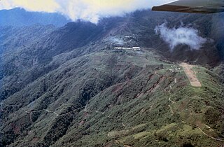
Huon Peninsula is a large rugged peninsula on the island of New Guinea in Morobe Province, eastern Papua New Guinea. It is named after French explorer Jean-Michel Huon de Kermadec. The peninsula is dominated by the steep Saruwaged and Finisterre and Cromwell Mountains. The nearest large town is the Morobe provincial capital Lae to the south, while settlements on the north coast include the former German town of Finschhafen, the district capital of Wasu, Malalamai and Saidor with its World War II era Saidor Airport.

The Torricelli Mountains are a mountain range in Sandaun Province, north-western Papua New Guinea. The highest peak in the range is Mount Sulen at 1650 meters. The Bewani Mountains are located to the west, and the Prince Alexander Mountains are located to the east. To the north, the mountains slope down to the Pacific Ocean, and to the south lies the basin of the Sepik River. Named after the Italian physicist and mathematician Evangelista Torricelli during the German colonial period.

<span class="mw-page-title-main">Northern Indochina subtropical moist forests</span> Ecoregion in Southeast Asia

The Northern Indochina subtropical moist forests are a subtropical moist broadleaf forest ecoregion of northern Indochina, covering portions of Vietnam, Laos, Thailand, Myanmar, and China's Yunnan Province.

<span class="mw-page-title-main">New Guinea Highlands</span> Natural region in New Guinea

The New Guinea Highlands, also known as the Central Range or Central Cordillera, is a long chain of mountain ranges on the island of New Guinea, including the island's tallest peak, Puncak Jaya, Indonesia, 16,024 ft (4,884 m), the highest mountain in Oceania. The range is home to many intermountain river valleys, many of which support thriving agricultural communities. The highlands run generally east-west the length of the island, which is divided politically between Indonesia in the west and Papua New Guinea in the east.

<span class="mw-page-title-main">Northern New Guinea lowland rain and freshwater swamp forests</span> Ecoregion in New Guinea

The Northern New Guinea lowland rain and freshwater swamp forests is a tropical moist broadleaf forest ecoregion of northern New Guinea.

<span class="mw-page-title-main">Central Range montane rain forests</span> Ecoregion in New Guinea

The Central Range montane rain forests is a tropical moist forest ecoregion on the island of New Guinea. The ecoregion covers the Central Range of the New Guinea Highlands, which extends along the spine of the island. The montane rain forests of the ecoregion are distinct from the surrounding lowland forests, and are home to many endemic plants and animals.

<span class="mw-page-title-main">Huon Peninsula montane rain forests</span>

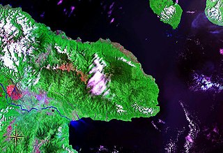
The Huon Peninsula montane rain forests is a tropical moist forest ecoregion in New Guinea. The ecoregion covers the mountains of northeastern New Guinea's Huon Peninsula.

<span class="mw-page-title-main">Borneo montane rain forests</span> Ecoregion in Borneo

The Borneo montane rain forests is an ecoregion on the island of Borneo in Southeast Asia. It includes montane tropical and subtropical moist broadleaf forests, also known as a cloud forests. The ecoregion is partly in East Malaysia and Indonesia (Kalimantan).

<span class="mw-page-title-main">Cardamom Mountains rain forests</span> Ecoregion in eastern Thailand and southwestern Cambodia

The Cardamom Mountains rain forests is a tropical moist broadleaf forest ecoregion in Southeast Asia, as identified by the WWF. The ecoregion covers the Cardamom Mountains and Elephant Mountains and the adjacent coastal lowlands in eastern Thailand and southwestern Cambodia, as well as the Vietnamese island of Dao Phu Quoc.

<span class="mw-page-title-main">Peninsular Malaysian montane rain forests</span> Ecoregion in Southern Thailand and Peninsular Malaysia

The Peninsular Malaysian montane rain forests is an ecoregion on Malay Peninsula. It occupies the mountainous spine of the peninsula in Malaysia and southernmost Thailand. It is in the tropical and subtropical moist broadleaf forests biome.

<span class="mw-page-title-main">Sulawesi lowland rain forests</span> Ecoregion in Sulawesi, Indonesia

The Sulawesi lowland rain forests is a tropical moist forest ecoregion in Indonesia. The ecoregion includes the lowlands of Sulawesi and neighboring islands.

<span class="mw-page-title-main">Sulawesi montane rain forests</span> Ecoregion in Sulawesi, Indonesia

The Sulawesi montane rain forests is a tropical moist forest ecoregion in Indonesia. It includes the highlands of Sulawesi.

<span class="mw-page-title-main">Vogelkop–Aru lowland rain forests</span> Ecoregion in Indonesia

The Vogelkop–Aru lowland rain forests is a tropical moist forest ecoregion in Indonesia. The ecoregion covers the peninsular lowlands of western New Guinea, along with the Aru Islands and other nearby islands.

<span class="mw-page-title-main">Vogelkop montane rain forests</span> Ecoregion in New Guinea

The Vogelkop montane rain forests is a tropical moist forest ecoregion in western New Guinea. The ecoregion covers the mountains of western New Guinea's Bird's Head and Bomberai peninsulas.

<span class="mw-page-title-main">New Britain–New Ireland montane rain forests</span>

The New Britain-New Ireland montane rain forests is a tropical moist forest ecoregion in Papua New Guinea. The ecoregion includes the mountain rain forests on the islands of New Britain and New Ireland, which lie northeast of New Guinea.

<span class="mw-page-title-main">Southeastern Papuan rain forests</span>

The Southeastern Papuan rain forests is a tropical moist forest ecoregion in southeastern New Guinea. The ecoregion covers the mountainous center and coastal lowlands of the Papuan Peninsula.

<span class="mw-page-title-main">Southern New Guinea lowland rain forests</span> Ecoregion in New Guinea

The Southern New Guinea lowland rain forests is a tropical moist forest ecoregion in southeastern New Guinea. The ecoregion covers portions of New Guinea's southern lowlands.

<span class="mw-page-title-main">Yapen rain forests</span> Ecoregion in Indonesia

The Yapen rain forests is a tropical moist forest ecoregion in Indonesia. The ecoregion covers the island of Yapen and smaller neighboring islands which lie north of New Guinea.

References

  1. Eric Dinerstein, David Olson, et al. (2017). An Ecoregion-Based Approach to Protecting Half the Terrestrial Realm, BioScience, Volume 67, Issue 6, June 2017, Pages 534–545; Supplemental material 2 table S1b.
  2. "Map of Ecoregions 2017". Resolve. Retrieved August 20, 2021.
  3. "Northern New Guinea montane rain forests". Digital Observatory for Protected Areas. Retrieved August 20, 2021.
  4. "Northern New Guinea montane rain forests". The Encyclopedia of Earth. Retrieved August 20, 2021.
  5. Wikramanayake, Eric; Eric Dinerstein; Colby J. Loucks; et al. (2002). Terrestrial Ecoregions of the Indo-Pacific: a Conservation Assessment. Washington, DC: Island Press.
  6. 1 2 3 "Northern New Guinea montane rain forests". Terrestrial Ecoregions. World Wildlife Fund.
  7. BirdLife International (2020) Endemic Bird Areas factsheet: North Papuan mountains. Accessed from http://www.birdlife.org on 06/06/2020.
  8. Eric Dinerstein, David Olson, et al. (2017). An Ecoregion-Based Approach to Protecting Half the Terrestrial Realm, BioScience, Volume 67, Issue 6, June 2017, Pages 534–545; Supplemental material 2 table S1b.