
Hardwicke is a village on the A38 road 7 km south of the city of Gloucester, Gloucestershire, England. Despite its proximity to Gloucester, the village comes under Stroud Council. The population of the village taken at the United Kingdom Census 2011 was 3,901.

St Michael at the North Gate is a church in Cornmarket Street, at the junction with Ship Street, in central Oxford, England. The name derives from the church's location on the site of the north gate of Oxford when it was surrounded by a city wall.
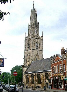
St Nicholas Church is a historic church in Westgate Street in the city of Gloucester, England, under the care of The Churches Conservation Trust. It is recorded in the National Heritage List for England as a designated Grade I listed building. Its truncated spire is a landmark in the city centre.
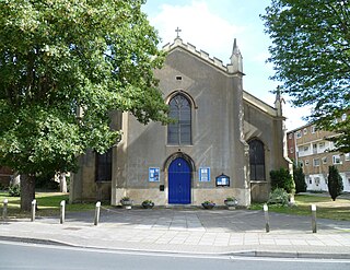
St Mary de Lode Church is a Church of England church immediately outside the grounds of Gloucester Cathedral. It is believed by some to be on the site of the first Christian church in Britain. The church is in the Diocese of Gloucester and Grade I listed by English Heritage. It has also been known as St. Mary Before the Gate of St. Peter, St. Mary Broad Gate and St. Mary De Port.

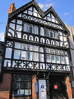
The New Inn, 16 Northgate Street, Gloucester, England, is a timber framed building used as a public house, hotel and restaurant. It is the most complete surviving example of a medieval courtyard inn with galleries in Britain, and is a Grade I listed building. The announcement of Lady Jane Grey's succession to the English throne was made from the Inn gallery in 1553.

The Westgate area of Gloucester is centred on Westgate Street, one of the four main streets of Gloucester and one of the oldest parts of the city. The population of the Westgate ward in Gloucester was 6,687 at the time of the 2011 Census.
Chester is a city in Cheshire, England. It contains over 650 structures that are designated as listed buildings by English Heritage and included in the National Heritage List for England. Of these, over 500 are listed at Grade II, the lowest of the three gradings given to listed buildings and applied to "buildings of national importance and special interest". This list contains the Grade II listed buildings in the unparished area of the city to the north and west of the Chester city walls.
Chester is a city in Cheshire, England containing over 650 structures that are designated as listed buildings by English Heritage and included in the National Heritage List for England. Of these, over 500 are listed at Grade II, the lowest of the three gradings given to listed buildings and applied to "buildings of national importance and special interest". This list contains the Grade II listed buildings in the central unparished area of the city within Chester city walls or located adjacent to them.

Hare Street House is a Grade II* listed building in the hamlet of Hare Street that lies between Buntingford and Great Hormead in the East Hertfordshire district of Hertfordshire, England. It is mainly associated with the Roman Catholic priest and writer Robert Hugh Benson who owned the house from 1906 until his death in 1914.

Bristol Road in the City of Gloucester dates from the medieval period. It runs between Southgate Street in the north and Quedgeley in the south where it joins the Bath Road and the A38. It contains a number of listed buildings and other notable structures.
Pitt Street in the City of Gloucester runs between the junction of Priory Road, Archdeacon Street, and St Mary's Street in the north and the junction of Hare Lane and Park Street in the south.

Worcester Street in the City of Gloucester runs between the junction of Alvin Street and Kingsholm Road in the north and Northgate Street in the south.

Barton Street is a street in the Barton and Tredworth district of Gloucester that is the location of a number of listed buildings:

Southgate Street is one of the ancient streets in the City of Gloucester, so named because its southern end was originally the location of the south gate in the city's walls. The part beyond the gate as far as Severn Street was sometimes known as Lower Southgate Street. It runs from the crossroads of Northgate, Eastgate, Southgate, and Westgate Streets in the north to Bristol Road in the south.

Commercial Road is located in the City of Gloucester, England. It runs from The Quay and Severn Road in the north to Kimbrose Way and Southgate Street in the south. It is joined by Barbican Road and Ladybellegate Street on the north side and by entrances to Gloucester Docks on the south side.
Stafford is a town in the Borough of Stafford, Staffordshire, England. The unparished area contains 141 buildings that are recorded in the National Heritage List for England as designated listed buildings. Of these, one is listed at Grade I, the highest grade, 15 are listed at Grade II*, the middle of the three grades, and the others are at Grade II, the lowest grade. This list contains the listed buildings in the central area of the town; those in the town but outside this area are in Listed buildings in Stafford.
Almondbury is a village and an unparished area in the metropolitan borough of Kirklees, West Yorkshire, England. Almondbury ward contains 118 listed buildings that are recorded in the National Heritage List for England. Of these, one is listed at Grade I, the highest of the three grades, four are at Grade II*, the middle grade, and the others are at Grade II, the lowest grade. The ward contains the village of Almondbury, the district of Moldgreen, and the surrounding area. Most of the listed buildings are houses and associated structures, cottages, farmhouses and farm buildings. Many of the houses were used in the domestic textile industry, and have long ranges of mullioned windows, especially in the upper storeys. The other listed buildings include a church and associated structures, a cross socket, textile mills, a mounting block, a public house, a police box, and a telephone kiosk.
Eastgate Street is one of the ancient streets in Gloucester, so named because its eastern end was originally the location of the east gate in the city's walls. The part beyond the gate as far as GL1 leisure Centre was part of Barton Street It runs from the crossroads of Northgate, Eastgate, Southgate and Westgate Streets in the West to Barton Street in the East.
Wakefield is a city in the metropolitan borough of the City of Wakefield, West Yorkshire, England. In the city and surrounding area are 190 listed buildings that are recorded in the National Heritage List for England. Of these, seven are listed at Grade I, the highest of the three grades, 18 are at Grade II*, the middle grade, and the others are at Grade II, the lowest grade. Historically a market town, it was the chief wool market in Yorkshire in the 18th century, and in the 19th century the cattle market was the largest in the north of England. The prosperity from this is reflected in the size of the parish church, and in the large number of fine Georgian houses, many of which are listed.


