
The Atlantic Ocean is the second-largest of the world's five oceans, with an area of about 106,460,000 km2 (41,100,000 sq mi). It covers approximately 20% of Earth's surface and about 29% of its water surface area. It is known to separate the "Old World" of Africa, Europe and Asia from the "New World" of the Americas in the European perception of the World.

A continental shelf is a portion of a continent that is submerged under an area of relatively shallow water known as a shelf sea. Much of these shelves were exposed by drops in sea level during glacial periods. The shelf surrounding an island is known as an insular shelf.

The Labrador Sea is an arm of the North Atlantic Ocean between the Labrador Peninsula and Greenland. The sea is flanked by continental shelves to the southwest, northwest, and northeast. It connects to the north with Baffin Bay through the Davis Strait. It is a marginal sea of the Atlantic.

An abyssal plain is an underwater plain on the deep ocean floor, usually found at depths between 3,000 metres (9,800 ft) and 6,000 metres (20,000 ft). Lying generally between the foot of a continental rise and a mid-ocean ridge, abyssal plains cover more than 50% of the Earth's surface. They are among the flattest, smoothest, and least explored regions on Earth. Abyssal plains are key geologic elements of oceanic basins.

A submarine canyon is a steep-sided valley cut into the seabed of the continental slope, sometimes extending well onto the continental shelf, having nearly vertical walls, and occasionally having canyon wall heights of up to 5 km, from canyon floor to canyon rim, as with the Great Bahama Canyon. Just as above-sea-level canyons serve as channels for the flow of water across land, submarine canyons serve as channels for the flow of turbidity currents across the seafloor. Turbidity currents are flows of dense, sediment laden waters that are supplied by rivers, or generated on the seabed by storms, submarine landslides, earthquakes, and other soil disturbances. Turbidity currents travel down slope at great speed, eroding the continental slope and finally depositing sediment onto the abyssal plain, where the particles settle out.
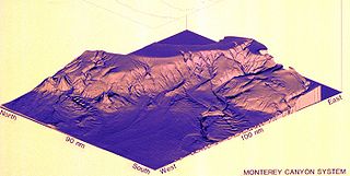
Monterey Canyon, or Monterey Submarine Canyon, is a submarine canyon in Monterey Bay, California with steep canyon walls measuring a full 1 mile in height from bottom to top, which height/depth rivals the depth of the Grand Canyon itself. It is the largest such submarine canyon along the West coast of the North American continent, and was formed by the underwater erosion process known as turbidity current erosion. Many questions remain unresolved regarding the exact nature of its origins, and as such it is the subject of several ongoing geological and marine life studies being carried out by scientists stationed at the nearby Monterey Bay Aquarium Research Institute, the Moss Landing Marine Laboratories, and other oceanographic institutions.
The Bengal Fan, also known as the Ganges Fan, is the largest submarine fan on Earth. The fan is about 3,000 km (1,900 mi) long, 1,430 km (890 mi) wide with a maximum thickness of 16.5 km (10.3 mi). The fan resulted from the uplift and erosion of the Himalayas and the Tibetan Plateau produced by the collision between the Indian Plate and the Eurasian Plate. Most of the sediment is supplied by the Ganges and Brahmaputra rivers which supply the Lower Meghna delta in Bangladesh and the Hoogly delta in West Bengal (India). Several other large rivers in Bangladesh and India provide smaller contributions. Turbidity currents have transported the sediment through a series of submarine canyons, some of which are more than 1,500 miles (2,414 km) in length, to be deposited in the Bay of Bengal up to 30 degrees latitude from where it began. To date, the oldest sediments recovered from the Bengal fan are from Early Miocene age. Their mineralogical and geochemical characteristics allow to identify their Himalayan origin and demonstrate that the Himalaya was already a major mountain range 20 million years ago.

The Hudson Canyon is a submarine canyon that begins from the shallow outlet of the estuary at the mouth of the Hudson River. It extends out over 640 km (400 mi) seaward across the continental shelf finally connecting to the deep ocean basin at a depth of 3 to 4 km below sea level. It begins as a natural channel of several kilometers width, starting as a 20–40 m depression at Hudson Channel southward from Ambrose Light, then carving through a deep notch of about 1 km depth in the shelf break, and running down the continental rise. Tidally associated flows of about 30 cm/s (1.1 km/h) up and down the deeper parts of the canyon have been recorded. As silt, sand and mud are carried down the Hudson River, they flow into the canyon and out into the deep sea.

Abyssal fans, also known as deep-sea fans, underwater deltas, and submarine fans, are underwater geological structures associated with large-scale sediment deposition and formed by turbidity currents. They can be thought of as an underwater version of alluvial fans and can vary dramatically in size, with widths from several kilometres to several thousands of kilometres The largest is the Bengal Fan, followed by the Indus Fan, but major fans are also found at the outlet of the Amazon, Congo, Mississippi and elsewhere.

PNA Dr. Bernardo A. Houssay (MOV-1) is a ketch rigged sail training and research vessel for the Argentine Naval Prefecture. Originally named the RV Atlantis, she served as the first and main research vessel for the Woods Hole Oceanographic Institution from 1931 to 1966. Several ships, including RV Atlantis (AGOR-25) and the Space ShuttleAtlantis (OV-104) were named after Atlantis. Having sailed over 1,300,000 miles to date, she is the oldest serving oceanographic research vessel in the world.
Abyssal channels are channels in Earth's sea floor. They are formed by fast-flowing floods of turbid water caused by avalanches near the channel's head, with the sediment carried by the water causing a build-up of the surrounding abyssal plains. Submarine channels and the turbidite systems which form them are responsible for the accumulation of most sandstone deposits found on continental slopes and have proven to be one of the most common types of hydrocarbon reservoirs found in these regions.

Submarine landslides are marine landslides that transport sediment across the continental shelf and into the deep ocean. A submarine landslide is initiated when the downwards driving stress exceeds the resisting stress of the seafloor slope material, causing movements along one or more concave to planar rupture surfaces. Submarine landslides take place in a variety of different settings, including planes as low as 1°, and can cause significant damage to both life and property. Recent advances have been made in understanding the nature and processes of submarine landslides through the use of sidescan sonar and other seafloor mapping technology.

A contourite is a sedimentary deposit commonly formed on continental rise to lower slope settings, although they may occur anywhere that is below storm wave base. Countourites are produced by thermohaline-induced deepwater bottom currents and may be influenced by wind or tidal forces. The geomorphology of contourite deposits is mainly influenced by the deepwater bottom-current velocity, sediment supply, and seafloor topography.
The Amazon Canyon is a submarine canyon within the Amazon Fan in the Atlantic Ocean, located approximately 200 mi (322 km) from the mouth of the Amazon River, near South America. It covers an area of 2,250 km2 (870 sq mi). It was formed in the mid to late Miocene period. The canyon is believed to have formed through mass failures, and subsequently evolved through underwater erosion. Because of its relatively small size, the canyon has been extensively mapped.

Congo Canyon is a submarine canyon found at the end of the Congo River in Africa. It is one of the largest submarine canyons in the world.
Cascadia Channel is the most extensive deep-sea channel currently known of the Pacific Ocean. It extends across Cascadia Abyssal Plain, through the Blanco Fracture Zone, and into Tufts Abyssal Plain. Notably, Cascadia Channel has tributaries, akin to river tributaries.

Juan de Fuca Channel is a submarine channel off the shore of Washington state, United States and the Strait of Juan de Fuca.

The Canadian Arctic Rift System is a major North American geological structure extending from the Labrador Sea in the southeast through Davis Strait, Baffin Bay and the Arctic Archipelago in the northwest. It consists of a series of interconnected rifts that formed during the Paleozoic, Mesozoic and Cenozoic eras. Extensional stresses along the entire length of the rift system have resulted in a variety of tectonic features, including grabens, half-grabens, basins and faults.
Cyclic steps are rhythmic bedforms associated with Froude super-critical flow instability. They are a type of sediment wave, and are created when supercritical sediment-laden water travels downslope through sediment beds. Each ‘step’ has a steep drop, and together they tend to migrate upstream. On the ocean floor, this phenomenon was first shown to be possible in 2006, although it was observed in open-channel flows over a decade earlier. Geological features appearing to be submarine cyclic steps have been detected in the northern lowlands of Mars in the Aeolis Mensae region, providing evidence of an ancient Martian ocean.
