
Simon Fraser was a Canadian explorer and fur trader who charted much of what is now the Canadian province of British Columbia. He also built the first European settlement in British Columbia.
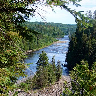
The Kaministiquia River is a river which flows into western Lake Superior at the city of Thunder Bay, Ontario. Kaministiquia is an Ojibwe word meaning "where a stream flows in island" due to two large islands at the mouth of the river. The delta has three branches or outlets, reflected on early North American maps in French as "les trois rivières" : the southernmost is known as the Mission River, the central branch as the McKellar River, and the northernmost branch as the Kaministiquia. Residents of the region commonly refer to the river as the Kam River.

Canoe camping, also known as touring, tripping or expedition canoeing, is a combination of canoeing and camping. Canoe campers carry enough with them to travel and camp for several days via a canoe.

The Hayes River is a river in Northern Manitoba, Canada, that flows from Molson Lake to Hudson Bay at York Factory. It was historically an important river in the development of Canada and is now a Canadian Heritage River and the longest naturally flowing river in Manitoba.
The trade center Fort Colvile was built by the Hudson's Bay Company (HBC) at Kettle Falls on the Columbia River in 1825 and operated in the Columbia fur district of the company. Named for Andrew Colvile, a London governor of the HBC, the fort was a few miles west of the present site of Colville, Washington. It was an important stop on the York Factory Express trade route to London via the Hudson Bay. The HBC for some time considered Fort Colvile second in importance only to Fort Vancouver, near the mouth of the Columbia, until the foundation of Fort Victoria.

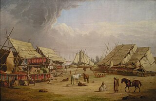
Grand Portage National Monument is a United States National Monument located on the north shore of Lake Superior in northeastern Minnesota that preserves a vital center of fur trade activity and Anishinaabeg Ojibwe heritage. The area became one of the British Empire's four main fur trading centers in North America, along with Fort Niagara, Fort Detroit, and Michilimackinac.
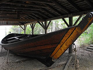
The York boat was a type of inland boat used by the Hudson's Bay Company to carry furs and trade goods along inland waterways in Rupert's Land, the watershed stretching from Hudson Bay to the eastern slopes of the Rocky Mountains. It was named after York Factory, the headquarters of the HBC, and by some accounts was supposedly modeled after the Orkney yole. Two variations to the York Boat were scows and "Sturgeon Heads."
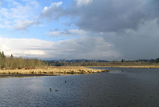
Burnaby Lake is a lake located in Burnaby, British Columbia and is the focal geographic feature and namesake of Burnaby Lake Regional Park. The lake occupies 3.11 square kilometres of land, and is home to a large variety of wildlife. At least 70 species of birds make the lake and surrounding areas their home, and about 214 species of birds visit the lake throughout the year. The park has been managed by the Metro Vancouver Parks Department since 1977.

Twelve paddlewheel steamboats plied the upper Fraser River in British Columbia from 1863 until 1921. They were used for a variety of purposes: working on railroad construction, delivering mail, promoting real estate in infant townsites and bringing settlers in to a new frontier. They served the towns of Quesnel, Barkerville and Fort George. Some only worked the Fraser from Soda Creek to Quesnel, while others went all the way to Tête Jaune Cache or took the Nechako River and served Fort Fraser and beyond.

Canoe River is the most northern tributary of the Columbia River in British Columbia, Canada. Its lower reach is flooded by Mica Dam. The lower Canoe River is called Canoe Reach, part of the Mica Dam's reservoir, Kinbasket Lake.

Frank Cyril Swannell was one of British Columbia's most famous surveyors.

The era of steamboats on the Arrow Lakes and adjoining reaches of the Columbia River is long-gone but was an important part of the history of the West Kootenay and Columbia Country regions of British Columbia Canada. The Arrow Lakes are formed by the Columbia River in southeastern British Columbia. Steamboats were employed on both sides of the border in the upper reaches of the Columbia, linking port towns on either side of the border, and sometimes boats would be built in one country and operated in the other. Tributaries of the Columbia include the Kootenay River which rises in Canada, then flows south into the United States, then bends north again back into Canada, where it widens into Kootenay Lake. As with the Arrow Lakes, steamboats once operated on the Kootenay River and Kootenay Lake.
The Hudson's Bay Brigade Trail, sometimes referred to simply as the Brigade Trail, refers to one of two routes used by Hudson's Bay Company fur traders to transport furs, goods and supplies between coastal and Columbia District headquarters at Fort Vancouver and those in New Caledonia and also in Rupert's Land. Importantly the route was that used by the annual "Hudson's Bay Express", a shipment of the company books and profits to company headquarters.
Dalles des Morts, also known as Death Rapids in English, was a famously violent stretch of the Columbia River upstream from Revelstoke, British Columbia, Canada, now submerged beneath the waters of the Lake Revelstoke Reservoir.

The York Factory Express, usually called "the Express" and also the Columbia Express and the Communication, was a 19th-century fur brigade operated by the Hudson's Bay Company (HBC). Roughly 4,200 kilometres (2,600 mi) in length, it was the main overland connection between HBC headquarters at York Factory and the principal depot of the Columbia Department, Fort Vancouver.

The Big Bend Highway is a 305-kilometre (190 mi) former highway in the interior of British Columbia, and was the original alignment of Highway 1 (Hwy 1) which followed the Columbia River between Revelstoke and Golden through the Selkirk Mountains.

From 1886 to 1920, steamboats ran on the upper reaches of the Columbia and Kootenay in the Rocky Mountain Trench, in western North America. The circumstances of the rivers in the area, and the construction of transcontinental railways across the trench from east to west made steamboat navigation possible.

This article covers the water based Canadian canoe routes used by early explorers of Canada with special emphasis on the fur trade.
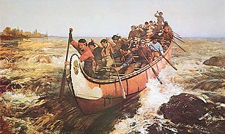
Voyageurs were 18th- and 19th-century French Canadians who transported furs by canoe at the peak of the North American fur trade. The emblematic meaning of the term applies to places and times where that transportation was over long distances. The voyageurs' strength and endurance was regarded as legendary. They were celebrated in folklore and music. For reasons of promised celebrity status and wealth, this position was coveted.
The Committee's Punch Bowl is a small tarn on the continental divide straddling the border between the Canadian provinces of Alberta and British Columbia. George Simpson, governor of the Hudson's Bay Company, named the lake for the London-based managing committee of that company in 1824. While journeying on an important trade route in the company's trade area in what is now western Canada and parts of Alaska and the northwestern United States, he saw the lake at the summit of Athabasca Pass.