Norton-sub-Hamdon

Last updated

Norton-sub-Hamdon
St Mary the Virgin parish church, Norton-sub-Hamdon, Somerset, seen from the southeast.jpg
St Mary's Church
Grade I listed [1]
Fields near Norton sub Hamdon - geograph.org.uk - 866613.jpg
Aerial view of main village centre
Somerset UK location map.svg
Red pog.svg
Norton-sub-Hamdon
Location within Somerset
Population743 (2011) [2]
OS grid reference ST470159
District
Shire county
Region
Country England
Sovereign state United Kingdom
Post town STOKE-SUB-HAMDON
Postcode district TA14
Dialling code 01935
Police Avon and Somerset
Fire Devon and Somerset
Ambulance South Western
UK Parliament
List of places
UK
England
Somerset
50°56′26″N2°45′20″W / 50.9406°N 2.7555°W / 50.9406; -2.7555

Norton-sub-Hamdon is a village and civil parish in the South Somerset district of the English county of Somerset, situated ten miles west of Yeovil. The village has a population of 743. [2]

Contents

The village of Chiselborough is 0.5 miles (0.8 km) to the south, and the village of Stoke-sub-Hamdon 1 mile (1.6 km) to the north.

History

The Manor House Manor House - Norton-Sub-Hamdon - geograph.org.uk - 457623.jpg
The Manor House

The majority of the houses and cottages in the village are made from the local stone, hamstone, which is taken from the nearby Ham Hill, from which the village gets its name: Norton sub Hamdon means "north farm below the hill farm". [3]

One of the Church's Stained Glass windows Stained glass, Norton Sub Hamdon - geograph.org.uk - 1499913.jpg
One of the Church's Stained Glass windows

After the Norman Conquest the manor was granted to Robert, Count of Mortain, who gave it to Grestein Abbey in Normandy, which administered it through Wilmington Priory in Sussex until it was confiscated by the crown in the 14th century. It was then given to the De la Pole family and inherited with the dukedom of Suffolk by the Seymours and in 1671 by the Earl of Aylesbury, before being broken up and sold off. [3]

The parish was part of the hundred of Houndsborough. [4]

Governance

There is a parish council.

The village falls within the Non-metropolitan district of South Somerset, which was formed on 1 April 1974 under the Local Government Act 1972. It has previously been part of Yeovil Rural District, [5] and the county of Somerset.

It is also part of the Yeovil county constituency represented in the House of Commons of the Parliament of the United Kingdom. The constituency elects one Member of Parliament (MP) by the first past the post system of election.

Localities

Little Norton

Little Norton
The mill is in the background Norton sub Hamdon, Little Norton Mill - geograph.org.uk - 1316908.jpg
Little Norton
The mill is in the background

Little Norton is a more or less contiguous hamlet to the east that includes the western fringe of Ham Hill an ancient hillfort (and scheduled Ancient Monument [6] and extends also to its southeast to High Wood and Bagnel Farm which is listed building. [7]

The only other listed building in the neighbourhood is the central Little Norton Mill, which is also Grade II listed; [8] its overshot waterwheel is 13 feet 9 inches (4.19 m) in diameter and was cast by G. Parsons of the Parrett engineers.

Landmarks

Homefield in Rectory Lane was previously known as Folly's. It dates from the 17th century and has been designated as a Grade II* listed building. [9]

The manor house was built in the 17th century and is now in multiple occupation. [10]

The village pub, the Lord Nelson Inn, also has 17th-century origins. [11]

Education

The original primary school dates from the mid 18th century. It is situated next to the churchyard and its dovecote. [12] A new school beside the Recreation Field was opened in 1997. [13]

Religious sites

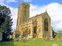
Church of St Mary the Virgin in Norton sub Hamdon has 13th century origins, but was largely rebuilt between 1500 and 1510. Further restoration was undertaken by Henry Wilson in 1894 and 1904. The five-stage tower, which rises 98.5 feet (30 m) was damaged by lightning and fire on 29 July 1894, but restored within a year, preserving the original design. [14] It has a double plinth, offset corner buttresses, dividing strings, battlemented parapet with pairs of corner pinnacles extended from buttresses, and central paired pinnacles corbelled off gargoyles. [15] The dovecote in the churchyard dates from the 17th century, [16] and was associated with a manor house which was demolished around 1850. [3]

Notable residents

Paddy Ashdown Paddy Ashdown 3.jpg
Paddy Ashdown

Related Research Articles

<span class="mw-page-title-main">Ashill, Somerset</span> Human settlement in England

Ashill is a small village and civil parish in Somerset, England, situated 7 miles (11.3 km) south of Taunton, and three miles north-west of Ilminster. The parish includes the hamlet of Windmill Hill and has a population of 529.

<span class="mw-page-title-main">Stoke St Gregory</span> Human settlement in England

Stoke St Gregory is a village and civil parish in Somerset, England, about 7 miles (11 km) east of Taunton. The village is on a low ridge of land between the River Tone to the north and West Sedgemoor to the south. The 2011 Census recorded the parish's population as 942.

<span class="mw-page-title-main">Chilthorne Domer</span> Human settlement in England

Chilthorne Domer is a village and parish in Somerset, England, situated 4 miles (6.4 km) north west of Yeovil in the South Somerset district. The village has a population of 574. It is situated on the old coach road from Ilchester to Yeovil.

<span class="mw-page-title-main">Chilton Cantelo</span> Human settlement in England

Chilton Cantelo is a village and parish in Somerset, England, situated on the River Yeo 5 miles (8 km) north of Yeovil and 4 miles (6 km) east of Ilchester in the South Somerset district. The village has a population of 445. The parish also includes the village of Ashington.

<span class="mw-page-title-main">Marston Magna</span> Human settlement in England

Marston Magna is a village and civil parish in Somerset, England, situated 5 miles (8.0 km) north of Yeovil in the South Somerset district. The village has a population of 523.

<span class="mw-page-title-main">Mudford</span> Village in England

Mudford is a village and parish in Somerset, England, situated 3 miles (4.8 km) from Yeovil in the South Somerset district on the River Yeo. The village has a population of 696. The parish includes the hamlets of Mudford Sock, West Mudford and Up Mudford.

<span class="mw-page-title-main">West Camel</span> Village in Somerset, England

West Camel is a village and civil parish in south Somerset, England, about 7 miles (11.3 km) north of the town of Yeovil. It lies either side of the River Cam, just south of the A303, and has a population of 459. The parish includes the hamlet of Urgashay. Neighbouring villages include Queen Camel, and Bridgehampton.

<span class="mw-page-title-main">Stoke-sub-Hamdon</span> Village in Somerset, England

Stoke-sub-Hamdon, also known as Stoke under Ham, is a large village and civil parish in the South Somerset district of Somerset, England. It is situated 5 miles (8 km) west of Yeovil, with which it is linked by the A3088 road. The parish is located near the River Parrett, and includes the village of East Stoke.

<span class="mw-page-title-main">Whitelackington</span> Human settlement in England

Whitelackington is a village and civil parish on the A303 one mile north east of Ilminster, in Somerset, England. The parish includes Dillington Park and the hamlets of Atherstone and Ashwell.

<span class="mw-page-title-main">Stoke sub Hamdon Priory</span> Grade I listed building in Somerset, England

Stoke sub Hamdon Priory is a complex of buildings and ruins which initially formed a 14th-century college for the chantry chapel of St Nicholas, and later was the site of a farm in Stoke-sub-Hamdon, Somerset, England. The only building remaining from the college is a great hall and attached dwelling, dating from the late 15th century. The hall is designated by English Heritage as a Grade I listed building, while the outbuildings and gateway are Grade II listed. The whole site has been scheduled as an ancient monument. A number of the farm buildings are in poor condition, and have been added to the Heritage at Risk Register.

<span class="mw-page-title-main">Pitcombe</span> Human settlement in England

Pitcombe is a village and civil parish 1 mile (2 km) south-west of Bruton and 5 miles (8 km) from Wincanton in Somerset, England. It has a population of 532. The parish includes the hamlets of Cole and Godminster.

<span class="mw-page-title-main">Wambrook</span> Human settlement in England

Wambrook is a village and civil parish in the Blackdown Hills, Somerset, England. The village lies about 2 miles (3 km) southwest of the town of Chard. The parish includes the hamlets of Higher Wambrook and Lower Wambrook which is sometimes known as Haselcombe.

<span class="mw-page-title-main">West Chinnock</span> Human settlement in England

West Chinnock is a village and former civil parish, now in the parish of West and Middle Chinnock, in the Somerset district, in the ceremonial county of Somerset, England. It is 4 miles (6.4 km) north east of Crewkerne. It occupies a central position east of the road that links Crewkerne to the A303 road and is mainly south of a brook that feeds nearby into the Parrett. The village forms the civil parish of West and Middle Chinnock with the neighbouring village of Middle Chinnock. The parish has a population of 592.

<span class="mw-page-title-main">Grade I listed buildings in South Somerset</span>

South Somerset is a local government district in the English county of Somerset. The South Somerset district occupies an area of 370 square miles (958 km2), stretching from its borders with Devon and Dorset to the edge of the Somerset Levels. The district has a population of about 158,000, and has Yeovil as its administrative centre.

<span class="mw-page-title-main">Church of St Mary the Virgin, Norton-sub-Hamdon</span> Church in Somerset, England

The Church of St Mary the Virgin in Norton Sub Hamdon, Somerset, England, has 13th-century origins but was rebuilt around 1510. It has been designated as a Grade I listed building.

<span class="mw-page-title-main">Church of St Mary the Virgin, East Stoke</span> Church in Somerset, England

The Church of St Mary the Virgin at East Stoke in Stoke-sub-Hamdon, Somerset, England dates from the 12th century. It has been designated as a Grade I listed building. It was previously dedicated to Saint Denis.

<span class="mw-page-title-main">Grade II* listed buildings in South Somerset</span>

South Somerset is a local government district in the English county of Somerset. The South Somerset district occupies an area of 370 square miles (958 km2), stretching from its borders with Devon and Dorset to the edge of the Somerset Levels. The district has a population of about 158,000, and has Yeovil as its administrative centre.

<span class="mw-page-title-main">Church of St Mary, Chilthorne Domer</span> Church in Somerset, England

The Anglican Church of St Mary in Chilthorne Domer, Somerset, England was built in the 13th century. It is a Grade II* listed building.

References

  1. St Mary's Church full listed (monuments are listed in own entries on the national list) Historic England. "Details from listed building database (1253811)". National Heritage List for England . Retrieved 27 October 2012.
  2. 1 2 "Statistics for Wards, LSOAs and Parishes — SUMMARY Profiles" (Excel). Somerset Intelligence. Retrieved 4 January 2014.
  3. 1 2 3 Bush, Robin (1994). Somerset: The complete guide. Wimborne: The Dovecote Press Ltd. pp.  159. ISBN   1-874336-26-1.
  4. "Somerset Hundreds". GENUKI. Retrieved 9 October 2011.
  5. "Yeovil RD". A vision of Britain Through Time. University of Portsmouth. Retrieved 4 January 2014.
  6. Hamdon Hill Camp Historic England. "Details from listed building database (1003678)". National Heritage List for England . Retrieved 27 October 2012.
  7. Bagnel Farm and farm buildings Historic England. "Details from listed building database (1260595)". National Heritage List for England . Retrieved 27 October 2012.
  8. Little Norton Mill Historic England. "Details from listed building database (1241094)". National Heritage List for England . Retrieved 27 October 2012.
  9. Historic England. "Homefield (1241341)". National Heritage List for England . Retrieved 1 February 2009.
  10. Historic England. "The Manor House (1241207)". National Heritage List for England . Retrieved 1 February 2009.
  11. Historic England. "Lord Nelson Inn (1241336)". National Heritage List for England . Retrieved 1 February 2009.
  12. Historic England. "Norton sub Hamdon Primary School (1260688)". National Heritage List for England . Retrieved 1 February 2009.
  13. "About Us". Norton-sub-Hamdon Primary School. Retrieved 5 August 2018.
  14. "Church Guide". Church of St Mary the Virgin, Norton Sub Hamdon. Archived from the original on 3 October 2011. Retrieved 6 March 2008.
  15. Historic England. "Church of St Mary the Virgin, Norton Sub Hamdon (1253811)". National Heritage List for England . Retrieved 6 March 2008.
  16. Historic England. "Dovecote in churchyard, about 15 metres south-west of church, Church of St. Mary the Virgin (1241076)". National Heritage List for England . Retrieved 1 February 2009.

Commons-logo.svg Media related to Norton Sub Hamdon at Wikimedia Commons