Astoria is a neighborhood in the western portion of the New York City borough of Queens. Astoria is bounded by the East River and is adjacent to three other Queens neighborhoods: Long Island City to the southwest, Sunnyside to the southeast, and Woodside to the east. As of 2019, Astoria has an estimated population of 95,446.

In architecture and city planning, a terrace or terraced house (UK) or townhouse (US) is a form of medium-density housing that originated in Europe in the 16th century, whereby a row of attached dwellings share side walls. They are also known in some areas as row houses or row homes.

Brownstone is a brown Triassic-Jurassic sandstone that was once a popular building material. The term is also used in the United States to refer to a townhouse clad in this, or any of a number of aesthetically similar materials.
The BMT Astoria Line is a rapid transit line of the B Division of the New York City Subway, serving the Queens neighborhood of Astoria. It runs south from Ditmars Boulevard in Astoria to 39th Avenue in Long Island City above 31st Street. It then turns west and serves Queensboro Plaza over Queens Plaza.
Starting in 1899, the Brooklyn Rapid Transit Company and Brooklyn–Manhattan Transit Corporation operated rapid transit lines in New York City — at first only elevated railways and later also subways.

Sunnyside is a neighborhood in the western portion of the New York City borough of Queens. It shares borders with Hunters Point and Long Island City to the west, Astoria to the north, Woodside to the east and Maspeth to the south. It contains the Sunnyside Gardens Historic District, one of the first planned communities in the United States.
The Grand Central Parkway (GCP) is a 14.61-mile long parkway that stretches from the Triborough Bridge in New York City to Nassau County on Long Island. At the Queens–Nassau border, it becomes the Northern State Parkway, which runs across the northern part of Long Island through Nassau County and into Suffolk County, where it ends in Hauppauge. The westernmost stretch also carries a short stretch of Interstate 278 (I-278). The parkway runs through Queens and passes the Cross Island Parkway, Long Island Expressway, LaGuardia Airport and Citi Field, home of the New York Mets. The parkway is designated New York State Route 907M (NY 907M), an unsigned reference route. Despite its name, the Grand Central Parkway was not named after Grand Central Terminal.

The Kaufman Astoria Studios is a movie studio located in the Astoria section of the New York City borough of Queens. The studio was constructed for Famous Players-Lasky in 1920, since it was close to Manhattan's Broadway theater district. The property was taken over by real estate developer George S. Kaufman in 1982 and renamed Kaufman Astoria Studios.
The West Bronx is a region in the New York City borough of the Bronx. The region lies west of the Bronx River and roughly corresponds to the western half of the borough.

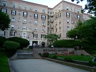
The Boulevard Gardens Apartments is a 960-unit apartment complex at 54th Street and 31st Avenue in Woodside, Queens, New York City. It opened in June 1935, during the Great Depression. They were designed by architect Theodore H. Englehardt for the Cord Meyer Development Corporation; the design was based on an apartment complex Elgelhardt designed in Forest Hills.
Mott Brooshovft Schmidt was an American architect best known for his buildings in the American Georgian Classical style.

The Norwood Club is a private club located in the Chelsea neighborhood of Manhattan in New York City. It was founded in 2007 by Alan Linn and Steve Ruggi, who intended it to be a modern incarnation of the traditional gentlemen's club. Like the fine arts focused Century Association, the Norwood Club draws its membership from New York City's arts and creative community. Linn describes the Norwood Club as a "club for the curious." The Norwood Club's members have reciprocity with other private clubs in London, Los Angeles, San Francisco, South Africa, Sydney, Paris, Dublin, Budapest, Toronto, Buenos Aires, and Shanghai.

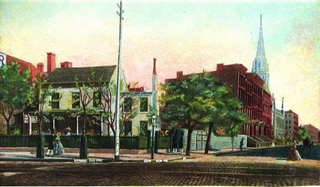
The Caspar Samler farm was a tract of land comprising the greater part of Fifth Avenue from Madison Square to 31st Street in what is now the Koreatown section of Manhattan, New York City, New York.

The Demarest Building is a multi-purpose commercial building at 339 Fifth Avenue in Midtown Manhattan, New York City. It was built by Aaron T. Demarest in 1890 in the downtown commerce district to showcase the high-end carriages that he manufactured. The building was the first with an electric elevator.

655 Park Avenue is a Georgian-style co-op residential building on Manhattan's Upper East Side, located on Park Avenue between 67th Street and 68th Street, adjacent to the Park Avenue Armory. It was developed in 1924 by Dwight P. Robinson & Company. The building at 655 Park Avenue was designed by architects James Edwin Ruthven Carpenter, Jr., often referred to by the initials "J.E.R. Carpenter", and Mott B. Schmidt. Carpenter is considered the leading architect for luxury residential high-rise buildings in New York City in the early 1900s, while Schmidt is known for his buildings in the American Georgian Classical style, including Sutton Place and houses for New York City's society figures and business elite.

Charles T. Mott was an architect in the U.S. He designed many rowhouses in Manhattan, New York City and Halliehurst (1890), for businessman and government official Stephen Benton Elkins who later became a U.S. Senator. Halliehurst is in what is now Elkins, West Virginia and is part of the Davis & Elkins College campus. He also designed an annex to the Seville Hotel building and many West Side Rowhouses in Manhattan, New York City. He was a fellow in the American Institute of Architects.

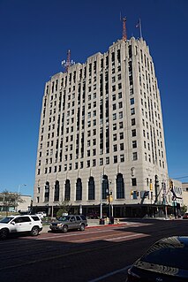
The Charles Stewart Mott Foundation Building is a 16-story office high-rise building in downtown Flint, Michigan. It is the tallest building in the city. Designed by Wirt C. Rowland in 1928 and opened in 1930, it was built as the Union Industrial Bank Building to serve as the headquarters for Union Industrial Bank. Rowland was considered innovative for his use of two materials in the building's construction: Nirosta for decorative purposes in the public spaces and aluminum for its storefronts and window frames.

Tribute Park is a 0.83-acre (0.34 ha) public green space in the Rockaway Park neighborhood of Queens, New York City. It is located at the corner of Beach Channel Drive and Beach 116th Street, facing Jamaica Bay.


