Norwood Young America, Minnesota

Last updated

Norwood Young America
Carver County Minnesota Incorporated and Unincorporated areas Norwood Young America Highlighted.svg
Location of the city of Norwood Young America
within Carver County, Minnesota
Coordinates: 44°46′19″N93°55′06″W / 44.77194°N 93.91833°W / 44.77194; -93.91833
Country United States
State Minnesota
County Carver
Merged1997
Area
[1]
  Total2.49 sq mi (6.46 km2)
  Land2.49 sq mi (6.45 km2)
  Water0.00 sq mi (0.00 km2)
Elevation
[2]
984 ft (300 m)
Population
 (2020)
  Total3,863
  Density1,550.16/sq mi (598.47/km2)
Time zone UTC-6 (CST)
  Summer (DST) UTC-5 (CDT)
ZIP codes
55368, 55397, 55473 plus about 20 more.
Area code 952
FIPS code 27-47520
GNIS feature ID2395278 [2]
Website www.cityofnya.com

Norwood Young America is a city in Carver County, Minnesota, United States, located about 40 miles west of Minneapolis. The city was formed in 1997 from the merging of two formerly independent cities, Norwood and Young America, which had been founded in the 19th century. The population was 3,549 at the 2010 census. [3]

Contents

History

Young America was platted in 1856. [4] Norwood was platted in 1872. [5]

Norwood Young America was formed on January 1, 1997 when Norwood and Young America merged. [6] The city has been called by the abbreviation NYA, but is often simply called either Norwood or Young America.[ citation needed ]

Geography

City Hall and Library 2009-0713-NYA-CH.jpg
City Hall and Library

According to the United States Census Bureau, the city has a total area of 2.52 square miles (6.53 km2), all land. [7]

US 212.svg US 212 MN-5.svg MN 5, and MN-25.svg MN 25 are three of the main routes in the community.

Demographics

Historical population
CensusPop.Note
2000 3,108
2010 3,54914.2%
2020 3,8638.8%
U.S. Decennial Census [8]
Historical population
CensusPop.Note
1880 338
1890 38513.9%
1900 50029.9%
1910 5224.4%
1920 5637.9%
1930 6077.8%
1940 6486.8%
1950 74915.6%
1960 94526.2%
1970 1,05812.0%
1980 1,21915.2%
1990 1,35110.8%
U.S. Census for Norwood [8]
Historical population
CensusPop.Note
1880 151
1890 28790.1%
1900 31810.8%
1910 303−4.7%
1920 33510.6%
1930 296−11.6%
1940 40637.2%
1950 365−10.1%
1960 47730.7%
1970 61128.1%
1980 1,237102.5%
1990 1,3549.5%
U.S. Census for Young America [8]

2010 census

As of the 2010 census, [9] there were 3,549 people, 1,389 households, and 954 families living in the city. The population density was 1,408.3 inhabitants per square mile (543.7/km2). There were 1,472 housing units at an average density of 584.1 per square mile (225.5/km2). The racial makeup of the city was 95.2% White, 0.4% African American, 0.2% Native American, 0.5% Asian, 2.4% from other races, and 1.2% from two or more races. Hispanic or Latino of any race were 4.1% of the population.

There were 1,389 households, of which 35.9% had children under the age of 18 living with them, 53.1% were married couples living together, 10.5% had a female householder with no husband present, 5.0% had a male householder with no wife present, and 31.3% were non-families. 25.6% of all households were made up of individuals, and 11.7% had someone living alone who was 65 years of age or older. The average household size was 2.55 and the average family size was 3.05.

The median age in the city was 35.8 years. 27.2% of residents were under the age of 18; 7.3% were between the ages of 18 and 24; 28.3% were from 25 to 44; 25.8% were from 45 to 64; and 11.5% were 65 years of age or older. The gender makeup of the city was 49.5% male and 50.5% female.

2000 census

Watertower in Norwood Young America Norwood Young America water tower.png
Watertower in Norwood Young America

As of the census of 2000, there were 3,108 people, 1,171 households, and 833 families living in the city. The population density was 1,855.8 inhabitants per square mile (716.5/km2). There were 1,201 housing units at an average density of 717.1 per square mile (276.9/km2). The racial makeup of the city was 98.10% White, 0.13% African American, 0.45% Native American, 0.42% Asian, 0.51% from other races, and 0.39% from two or more races. Hispanic or Latino of any race were 2.64% of the population.

There were 1,171 households, out of which 40.5% had children under the age of 18 living with them, 58.2% were married couples living together, 8.5% had a female householder with no husband present, and 28.8% were non-families. 24.2% of all households were made up of individuals, and 11.7% had someone living alone who was 65 years of age or older. The average household size was 2.65 and the average family size was 3.19.

In the city, the population was spread out, with 29.4% under the age of 18, 9.9% from 18 to 24, 31.0% from 25 to 44, 18.0% from 45 to 64, and 11.7% who were 65 years of age or older. The median age was 33 years. For every 100 females, there were 93.9 males. For every 100 females age 18 and over, there were 92.9 males.

The median income for a household in the city was $46,152, and the median income for a family was $54,792. Males had a median income of $36,292 versus $26,837 for females. The per capita income for the city was $18,431. About 2.7% of families and 5.6% of the population were below the poverty line, including 4.7% of those under age 18 and 8.2% of those age 65 or over.

Politics

Presidential election results
Precinct General Election Results [10]
Year Republican Democratic Third parties
2020 67.4%1,48930.3% 6702.3% 51
2016 65.2%1,24327.0% 5157.8% 150
2012 61.8%1,11835.6% 6442.6% 46
2008 60.1%1,07737.0% 6632.9% 51
2004 67.1%1,09832.1% 5250.8% 14
2000 59.5%76732.7% 4227.8% 100

Business

In 1973, the Dile Corporation moved to Young America, and changed its name to Young America Corporation. It is one of the town's largest employers, processing rebate, coupon, and other marketing programs for businesses. It receives a great deal of mail, enough that this small town has over 20 ZIP codes. A main one is 55555.

The town has a main junction of the Twin Cities and Western Railroad, which connects with its wholly-owned subsidiary, the Minnesota Prairie Line, just east of downtown. [11]

Norwood Young America has several buildings listed on the National Register of Historic Places.

Arts and culture

Norwood Young America is home to Stiftungsfest, Minnesota's oldest festival (dating to 1861).

Related Research Articles

<span class="mw-page-title-main">Funkley, Minnesota</span> City in Minnesota, United States

Funkley is a city in Beltrami County, Minnesota, United States. The population was 18 at the 2020 census, making the city the second-least populous incorporated place in Minnesota. It shared that distinction with Tenney until the latter dissolved in 2011.

<span class="mw-page-title-main">Foley, Minnesota</span> City in Minnesota, United States

Foley is a city and the county seat of Benton County, Minnesota, United States. The population was 2,711 at the 2020 census.

<span class="mw-page-title-main">Backus, Minnesota</span> City in Minnesota, United States

Backus is a city in Cass County, Minnesota, United States. The population was 250 at the 2010 census. It is part of the Brainerd Micropolitan Statistical Area.

<span class="mw-page-title-main">Emily, Minnesota</span> City in Minnesota, United States

Emily is a city in Crow Wing County, Minnesota, United States. The population was 843 at the 2020 census. It is part of the Brainerd Micropolitan Statistical Area.

<span class="mw-page-title-main">Jenkins, Minnesota</span> City in Minnesota, United States

Jenkins is a city in Crow Wing County, Minnesota, United States. The population was 430 at the 2010 census. It is part of the Brainerd Micropolitan Statistical Area.

<span class="mw-page-title-main">Mora, Minnesota</span> City in Minnesota, United States

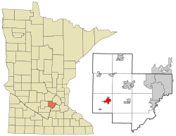
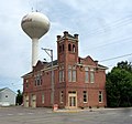
Mora is a city and the county seat of Kanabec County, Minnesota It is located at the junction of Minnesota highways 23 and 65 and is along the Snake River. The population was 3,665 at the 2020 Census.

<span class="mw-page-title-main">Glencoe, Minnesota</span> City in the United States

Glencoe is a city and the county seat of McLeod County, Minnesota, United States. The population was 5,744 at the 2020 census.

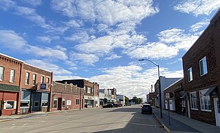
Helen Township is a township in McLeod County, Minnesota, United States. The population was 833 at the 2020 census.

<span class="mw-page-title-main">Plato, Minnesota</span> City in Minnesota, United States

Plato is a city in southeastern McLeod County, Minnesota, United States. The population was 329 at the 2020 census.

<span class="mw-page-title-main">Dassel, Minnesota</span> City in Minnesota, United States

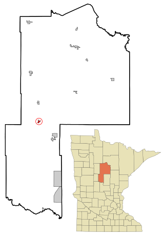
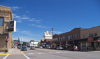
Dassel is a city in Meeker County, Minnesota, United States. The population was 1,472 at the 2020 census.

<span class="mw-page-title-main">Racine, Minnesota</span> City in Minnesota, United States

Racine is a city in Racine Township, Mower County, Minnesota, United States. The population was 442 at the 2010 census.

<span class="mw-page-title-main">Clitherall, Minnesota</span> City in Minnesota, United States

Clitherall is a city in Otter Tail County, Minnesota, United States. The population was 62 at the 2020 census.

<span class="mw-page-title-main">Winger, Minnesota</span> City in Minnesota, United States

Winger is a city in Polk County, Minnesota, United States. It is part of the Grand Forks, ND-MN Metropolitan Statistical Area. The population was 174 at the 2020 census.

<span class="mw-page-title-main">Lamberton, Minnesota</span> City in Minnesota, United States

Lamberton is a town in Redwood County, Minnesota, United States. The population was 824 at the 2010 census.

<span class="mw-page-title-main">Gaylord, Minnesota</span> City in Minnesota, United States

Gaylord is a city and the county seat of Sibley County, Minnesota, United States, along the shore of Titlow Lake. It is approximately 65 miles (105 km) west-southwest of Minneapolis-St. Paul. The population was 2,305 at the 2010 census.

<span class="mw-page-title-main">Green Isle, Minnesota</span> City in Minnesota, United States

Green Isle is a city in Sibley County, Minnesota, United States. The population was 522 at the 2020 census.

<span class="mw-page-title-main">Gilbert, Minnesota</span> City in Minnesota, United States

Gilbert is a city in St. Louis County, Minnesota, United States. The population was 1,799 at the 2010 census. State Highway 37 and State Highway 135 are two of the main routes in Gilbert. Gilbert is part of the Quad Cities, with Virginia, Eveleth, and Mountain Iron. The city is named for Giles Gilbert, who led the exploration of the McKinley mine property in the 1890s.

<span class="mw-page-title-main">Centerville, Minnesota</span> City in Minnesota, United States

Centerville is a city in Anoka County, Minnesota, United States. The population was 3,896 at the 2020 census.

<span class="mw-page-title-main">Blooming Prairie, Minnesota</span> City in Minnesota, United States

Blooming Prairie is a city in Dodge and Steele counties in the U.S. state of Minnesota. The population was 1,996 at the 2010 census. Most of the city is located within Steele County; only a small part of the city extends into Dodge County.

<span class="mw-page-title-main">Chatfield, Minnesota</span> City in Minnesota, United States

Chatfield is a city in Fillmore and Olmsted counties in the U.S. state of Minnesota. The population was 2,779 at the 2010 census. The city's area is split almost equally between the two counties. Chatfield is known as "The Gateway to Bluff Country" and "The Chosen Valley".

References

  1. "2020 U.S. Gazetteer Files". United States Census Bureau. Retrieved July 24, 2022.
  2. 1 2 U.S. Geological Survey Geographic Names Information System: Norwood Young America, Minnesota
  3. "2010 Census Redistricting Data (Public Law 94-171) Summary File". American FactFinder. United States Census Bureau . Retrieved April 27, 2011.[ dead link ]
  4. Upham, Warren (1920). Minnesota Geographic Names: Their Origin and Historic Significance. Minnesota Historical Society. p.  84.
  5. Upham, Warren (1920). Minnesota Geographic Names: Their Origin and Historic Significance. Minnesota Historical Society. p.  83.
  6. "Population Estimates 1990s Geographic Change Notes: Minnesota". U.S. Census Bureau. Retrieved May 23, 2007.
  7. "US Gazetteer files 2010". United States Census Bureau. Archived from the original on January 25, 2012. Retrieved November 13, 2012.
  8. 1 2 3 "Census of Population and Housing". Census.gov. Retrieved May 4, 2019.
  9. "U.S. Census website". United States Census Bureau . Retrieved November 13, 2012.
  10. "Office of the Minnesota Secretary of State - Election Results".
  11. "TC&W Railroad Map | Largest MN Shortline Rail | MN Rail Map".