Dublin is the capital and largest city of Ireland. On a bay at the mouth of the River Liffey, it is in the province of Leinster, bordered on the south by the Dublin Mountains, a part of the Wicklow Mountains range. At the 2022 census, the city council area had a population of 592,713, while Dublin City and its suburbs had a population of 1,263,219, and County Dublin had a population of 1,501,500.

Dublin Castle is a major Irish government complex, conference centre, and tourist attraction. It is located off Dame Street in central Dublin.

The River Liffey is a river in eastern Ireland that ultimately flows through the centre of Dublin to its mouth within Dublin Bay. Its major tributaries include the River Dodder, the River Poddle and the River Camac. The river supplies much of Dublin's water and supports a range of recreational activities.

Merrion Square is a Georgian garden square on the southside of Dublin city centre.

Ringsend is a southside inner suburb of Dublin, Ireland. It is located on the south bank of the River Liffey and east of the River Dodder, about two kilometres east of the city centre. It is the southern terminus of the East Link Toll Bridge. Areas included in Ringsend are the south side of the Dublin Docklands, and at the west end is the area of South Lotts and part of the Grand Canal Dock area. Neighbouring areas include Irishtown, Sandymount and the Beggars Bush part of Ballsbridge to the south, and the city centre to the west. A key feature of the area is the chimneys of Poolbeg power station.

Mountjoy Square is a garden square in Dublin, Ireland, on the Northside of the city just under a kilometre from the River Liffey. One of five Georgian squares in Dublin, it was planned and developed in the late 18th century by Luke Gardiner, 1st Viscount Mountjoy. It is surrounded on all sides by terraced, red-brick Georgian houses. Construction of the houses began piecemeal in 1792 and the final property was completed in 1818.

Baggot Street is a street in Dublin, Ireland.

Gardiner Street is a long Georgian street in Dublin, Ireland. It stretches from the River Liffey at its southern end via Mountjoy Square to Dorset Street at its northern end. The Custom House terminates the vista at the southern end, and the street is divided into Gardiner Street Upper, Gardiner Street Middle and Gardiner Street Lower.

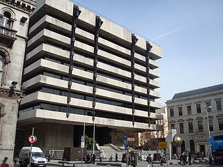
Sam Stephenson was an Irish architect who studied at the Bolton Street School of Architecture, which is now known as Technological University Dublin. Many of his buildings generated considerable controversy when they were built.

Poolbeg is an artificial peninsula extending from Ringsend, Dublin, into Dublin Bay.

Fitzwilliam Square is a Georgian garden square in the south of central Dublin, Ireland. It was the last of the five Georgian squares in Dublin to be built, and is the smallest.

D'Olier Street is a street in the southern city-centre of Dublin, the capital of Ireland. It and Westmoreland Street are two broad streets whose northern ends meet at the southern end of O'Connell Bridge over the River Liffey. Its southern end meets Fleet Street, Townsend Street, College Street and Pearse Street.

The Dublin quays refers to the two roadways and quays that run along the north and south banks of the River Liffey in Dublin, Ireland. The stretches of the two continuous streets have several different names. However, all but two of the names share the same "quay" designation. The quays have played an important part in Dublin's history.

Clanbrassil Street is a street in Dublin south of the city centre. It runs from Robert Emmet Bridge on the Grand Canal to New Street. It is served by several bus routes. It is divided into Clanbrassil Street Upper and Clanbrassil Street Lower.

South Lotts is a small area to the south of the river Liffey in inner-city Dublin 4, one km east of Dublin City Centre, Ireland. It was created following the embankment of the River Liffey in 1711 between the city and Ringsend, thereby reclaiming the marshes as North and South Lotts. It is at the westernmost end of Ringsend, overlapping with the Grand Canal Dock area, but is generally accepted to be within Ringsend.

Aldborough House is a large Georgian house in Dublin, Ireland. Built as a private residence by 1795, the original structure included a chapel and a theatre wing.
The Docklands Strategic Development Zone (SDZ) (known officially as the North Lotts and Grand Canal Dock SDZ Planning Scheme) is a controversial strategic planning area in Dublin, Ireland located east of the city centre on both sides of the River Liffey in the North Wall and Grand Canal Dock areas.

Hawkins Street is a street in central Dublin, Ireland. It runs south from Rosie Hackett Bridge, at its junction with Burgh Quay, for 160 metres (170 yd) to a crossroads with Townsend Street, where it continues as College Street.

Buckingham Street is a street in Dublin running from Summerhill to Amiens Street. It is divided into Buckingham Street Lower and Buckingham Street Upper.


