This article needs additional citations for verification .(April 2021) |
Nursery is an unincorporated community in the Similkameen Division Yale Land District of British Columbia. The community is east of Grand Forks, British Columbia. [1]
This article needs additional citations for verification .(April 2021) |
Nursery is an unincorporated community in the Similkameen Division Yale Land District of British Columbia. The community is east of Grand Forks, British Columbia. [1]

The Stickeen Territories, also colloquially rendered as Stickeen Territory,Stikine Territory, and Stikeen Territory, was a territory of British North America whose brief existence began July 19, 1862, and concluded July of the following year. The region was split from the North-Western Territory in the wake of the Stikine Gold Rush. The initial strike attracted large numbers of miners — mostly American — to the region; by detaching the region from the exclusive trade zone of the Hudson's Bay Company, British authorities were able to impose tariffs and licences on the speculators. The new territory, named after the Stikine River, was under the responsibility of the Governor of the Colony of British Columbia, James Douglas, who was appointed "Administrator of the Stickeen Territories" and under British law, within the jurisdiction of the Supreme Court of British Columbia.
Boundary Creek Provincial Park is a provincial park in British Columbia, Canada located south of Greenwood BC in that province's Boundary Country, adjacent to BC Highway 3. The eponymous Boundary Creek flows through the park.
Boulder Creek Provincial Park is a provincial park in British Columbia, Canada, located to the west of BC Highway 16 near Smithers, in the Bulkley Valley.
Victor Lake Provincial Park is a provincial park in British Columbia, Canada, located southwest of Revelstoke to the north of Three Valley Lake.
Cinnemousun Narrows Provincial Park is a provincial park in British Columbia, Canada, located on Shuswap Lake at the convergence of the lake's four arms.
Emar Lakes Provincial Park is a provincial park in British Columbia, Canada.

The French submarine Rubis was a Saphir-class minelaying submarine which first served in the French submarine pavilion, then the Free French Naval Forces (FNFL) during the Second World War and back with the French Navy. The boat was awarded numerous awards. Accordingly, as a result of Rubis's service with the FNFL, the boat was made a companion of the Ordre de la Libération by a decree issued by General Charles de Gaulle on 14 October 1941.
Silverdale is a semi-rural neighbourhood of the District of Mission, British Columbia, Canada c. 40 km east of Vancouver on the east bank of the Stave River at its confluence with the Fraser. Noted for its historic Italian Canadian community, its economy was farming, fishing and logging based until the general suburbanization of Fraser Valley life in the 1960s and 1970s. Of its Italian community, notable offspring include Phil Gaglardi, former BC Highways minister, and speed-skater Eden Donatelli. Silverdale is also notable as the site of Canada's first train robbery, by the "Gentleman Bandit" Billy Miner, and it is there he is supposed to have first used the polite "Hands Up!" in the course of the robbery.
The Tahltan River is a river in northern British Columbia, Canada. It flows southwest into the Stikine River. The First Nations community of Tahltan is located at the confluence.
The Qualicum River /in the Pentlach language = "Where the Dog Salmon Run" / is a river on the east coast of Vancouver Island, British Columbia, Canada, flowing northeast from its headwaters in Horne Lake into the Strait of Georgia just south of Qualicum Bay, near the town of Qualicum Beach. The river's name comes from that of the Qualicum people.
Cascade Falls is a waterfall on the Kettle River in the Boundary Country of the Southern Interior of British Columbia. They are located just south of Christina Lake and just north of the Canada–United States border in a gorge 200-300 yards long and just below the railway bridge over the Kettle by the southern mainline of the Canadian Pacific Railway. The ghost town of Cascade City aka Cascade is nearby and was named for the falls, even though they were not officially named until 1977.
Yale First Nation is a First Nations government located at Yale, British Columbia. Yale has 16 distinct reserves stretching from near Sawmill Creek to American Creek, with the most southern reserve situated at Ruby Creek in the District of Kent.
The Lyackson First Nation is a First Nations band government located at Chemainus, British Columbia, Canada, on Vancouver Island.
The Trout River is a tributary of the Liard River in far northern British Columbia, Canada, flowing northwest from headwaters at 58°44′N126°14′W, near Muncho Lake, to meet the Liard at the community of Liard River. It is at the upper end of the Grand Canyon of the Liard, which is part of Liard River Corridor Provincial Park and Protected Area.
Almond Gardens is a populated community in the Similkameen Division Yale Land District of British Columbia. The small community is southwest of Grand Forks, British Columbia.
Rose Lake is an unincorporated community on the Yellowhead Highway in the Bulkley Valley region of northwestern British Columbia, Canada. Its name is derived from the nearby waterbody Rose Lake. The community and the lake are along the northern mainline of the Canadian National Railway just northeast of Bulkley Lake.
Lindell Beach is a rural farming village in the Columbia Valley of the Lower Mainland region of the province of British Columbia, Canada, lying south of the City of Chilliwack. It is located at the south end of Cultus Lake which is the main waterbody in the Columbia Valley in the South Fraser Valley, and just north of the boundary of the United States.
Atchelitz is a rural community within the City of Chilliwack in the Eastern Fraser Valley region of British Columbia, Canada. It is located southwest of the city core, to the north of the Vedder Canal.
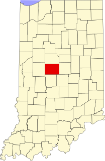
Dale is an unincorporated community in Center Township, Boone County, in the U.S. state of Indiana.
Coordinates: 49°01′00″N118°24′00″W / 49.01667°N 118.40000°W
| | This article about a location in the Interior of British Columbia, Canada is a stub. You can help Wikipedia by expanding it. |