Limpopo is the northernmost province of South Africa. It is named after the Limpopo River, which forms the province's western and northern borders. The capital and largest city in the province is Polokwane.

A provincial park is a park administered by one of the provinces of a country, as opposed to a national park. They are similar to state parks in other countries. They are typically open to the public for recreation. Their environment may be more or less strictly protected. Argentina, Belgium, Canada and South Africa are among the countries that have provincial parks.

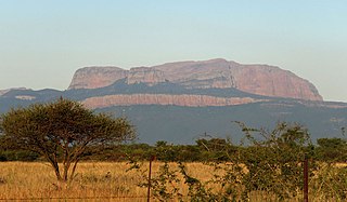
The Soutpansberg, meaning "Salt Pan Mountain" in Afrikaans, is a range of mountains in far northern South Africa. It is located in Vhembe District, Limpopo. It is named for the salt pan located at its western end. The mountain range reaches the opposite extremity in the Matikwa Nature Reserve, some 107 kilometres (66 mi) due east. The range as a whole had no Venda name, as it was instead known by its sub-ranges which include Dzanani, Songozwi and others. Of late it is however known as Tha vhani ya muno, meaning "mountain of salt".

Vhembe is one of the 5 districts of Limpopo province of South Africa. It is the northernmost district of the country and shares its northern border with Beitbridge district in Zimbabwe and on the east with Gaza Province in Mozambique. Vhembe consist of all territories that were part of the former Venda Bantustan, however, two large densely populated districts of the former Tsonga homeland of Gazankulu, in particular, Hlanganani and Malamulele were also incorporated into Vhembe, hence the ethnic diversity of the District. The seat of Vhembe is Thohoyandou, the capital of the former Venda Bantustan. According to 2011 census, the majority of Vhembe residents, about 800,000, speak TshiVenda as their mother language, while 400,000 speak Xitsonga as their home language. However, the Tsonga people are in majority south of Levubu River and they constitute more than 85% of the population in the south of the historic river Levubu, while the Venda are the minority south of Levubu, at 15%. The Northern Sotho speakers number 27,000. The district code is DC34.

Mapungubwe National Park is a national park in Limpopo Province, South Africa. It is located by the Kolope River, south of the confluence of the Limpopo and Shashe rivers and about 15 kilometres (9.3 mi) to the NE of the Venetia Diamond Mine. The National Park borders Mapesu Private Game Reserve to the south. It abuts on the border with Botswana and Zimbabwe, and forms part of the Greater Mapungubwe Transfrontier Conservation Area. It was established in 1995 and covers an area of over 28,000 hectares. The park protects the historical site of Mapungubwe Hill, which was the capital of the Kingdom of Mapungubwe, as well as the wildlife and riverine forests along the Limpopo River. The Mapungubwe Hill was the site of a community dating back to the Iron Age. Evidences have shown that it was a prosperous community. Archaeologists also uncovered the famous golden rhino figurine from the site. It is one of the few places in Africa that has both meerkats and Nile crocodiles.
Limpopo Tourism and Parks Board is a governmental organisation established in 2001 and responsible for maintaining wilderness areas and public nature reserves in Limpopo Province, South Africa.

The Tuli Block is a narrow fringe of land at Botswana's eastern border wedged between Zimbabwe in the north and east and South Africa in the south. It consists mainly of privately owned game farms offering safari tourism. The eastern section up to and including Redshield has been declared a game reserve, known as the Northern Tuli Game Reserve.

Balule Nature Reserve is a protected area in Limpopo Province, South Africa which forms part of the Greater Kruger National Park as a member of the Associated Private Nature Reserves (APNR). As part of a wildlife conservation initiative, all fences separating APNR reserves – Balule, Timbavati, Klaserie, Umbabat, Grietjie Private Nature Reserve – and the Kruger National Park have been removed. The ecological benefits of this initiative has made the region a popular ecotourism destination and conservation efforts have ensured that the wildlife population includes all of the Big Five game: lion, African bush elephant, African buffalo, African leopard and black rhinoceros.

Blouberg Nature Reserve is a protected area situated close to Vivo, west of Louis Trichardt in the Limpopo Province, of South Africa. It covers an area of 9,360 hectares from the eastern portion of the Blouberg mountain range down to the savanna near the Brak River, and is founded by Pieter Dix but was sold and now managed and administrated by the Limpopo Provincial Government.

The Mokolo Dam Nature Reserve or Mokolo Dam Provincial Parkis a protected area of bushveld in the Limpopo province, South Africa. It almost surrounds the Mokolo Dam on the Mokolo River. It is located 32 km south of Lephalale, just northeast of the Marakele National Park and not far from the Lapalala Game Reserve.
Soutpansberg Conservancy, also known as Western Soutpansberg Conservancy, is a protected area situated in the northern part of the Limpopo province of South Africa. The reserve has an area of about 90,000 Ha and consists mostly in the mountainous terrain of the western part of the Soutpansberg Range. The Brak River, a tributary of the Sand River, flows beyond the western end of the Soutpansberg Conservancy. The Waterpoort, the deep gorge cut by the Sand River across the range is located in the central part of the protected area.

The Levubu River or Levuvhu is located in the northern Limpopo province of South Africa. Some of its tributaries, such as the Mutshindudi River and Mutale River rise in the Soutpansberg Mountains.
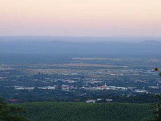
Louis Trichardt, informally shortened to Louis Tri, is a town at the foot of Songozwi, in the Soutpansberg mountain range in the Limpopo province of South Africa. It is the centre of the Makhado Local Municipality, which comprises 16,000 km² with a total population of 270,000 (2001). Louis Trichardt is located in a fertile region where litchis, bananas, mangoes and nuts are produced. The N1 National Route runs through the town. Louis Trichardt is 437 kilometres from Johannesburg and one hour's drive from the Zimbabwean border at Beitbridge. Louis Trichardt was known for a time as Makhado, but it was changed back to Louis Trichardt. But now many people use the one name or the other. Vleifontein, Elim, Tshikota, Madombidzha, Makhado Park and Dzanani surround the town at all directions.
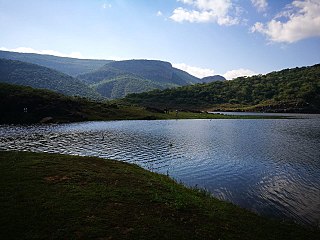
Lake Fundudzia.k.a.Lake Funduzi is located in the Soutpansberg in the Limpopo Province of South Africa. Measuring about 5 km by 3 km when full, it was created by an ancient landslide blocking the course of the Mutale River. The lake and its resident crocodiles as well as the nearby forest of Thathe Vondo, are regarded as sacred by the Vhatavhatsindi, the People of the Pool who are part of the Venda people.
The Blouberg, meaning "Blue Mountain" in Dutch, is a range of mountains in Limpopo Province, at the far north of South Africa. It is located in Blouberg Local Municipality, Capricorn District. The mountain is entrenched in the history of the local Northern Sotho people, and they have different names for its various parts.
The Nwanedi River is a watercourse in Limpopo Province, South Africa. It is a tributary of the Limpopo River flowing east of the Nzhelele, joining the right bank of the Limpopo 58 km east of Musina at the South Africa/Zimbabwe border.

The Shingwedzi River, is a river in Limpopo Province, South Africa and Gaza Province, Mozambique. It is a left hand tributary of the Olifants River (Rio dos Elefantes) and the northernmost river of its catchment area, joining it at the lower end of its basin. The Shingwedzi is a seasonal river whose riverbed is dry for prolonged periods.
Luphephe River is a tributary of the Nwanedi River in Limpopo Province, South Africa.
Mapesu Private Game Reserve is a game reserve in Limpopo Province, South Africa. The reserve adjoins the Mapungubwe National Park and World Heritage Site, with which it shares a 12.5 km Northern border. The main entrance gate to the reserve is located approximately 7 km east of Mapungubwe's entrance gate. It was established in 2014 and covers an area of over 7,200 hectares. The reserve protects various bird, mammal and tree species and is slated to become part of the Greater Mapungubwe Transfrontier Conservation Area in phase 2 as part of the proposed Limpopo Valley Game Reserve.