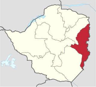
Manicaland is a province in eastern Zimbabwe. After Harare Province, it is the country's second-most populous province, with a population of 2.037 million, as of the 2022 census. After Harare and Bulawayo provinces, it is Zimbabwe's third-most densely populated province. Manicaland was one of five original provinces established in Southern Rhodesia in the early colonial period. The province endowed with country's major tourist attractions, the likes of Mutarazi Falls, Nyanga National Park and Zimbabwe's top three highest peaks. The province is divided into ten administrative subdivisions of seven rural districts and three towns/councils, including the provincial capital, Mutare. The name Manicaland is derived from one of the province's largest ethnic groups, the Manyika, who originate from the area north of the Manicaland province and as well as western Mozambique, who speak a distinct language called ChiManyika in Shona.

Mutare, originally known as Umtali, is the most populous city in the province of Manicaland, and the third most populous city in Zimbabwe, having surpassed Gweru in the 2012 census, with an urban population of 224,802 and approximately 260,567 in the surrounding districts giving the wider metropolitan area a total population of over 500,000 people. Mutare is also the capital of Manicaland province and the largest city in Eastern Zimbabwe.

The Eastern Highlands, also known as the Manica Highlands, is a mountain range on the border of Zimbabwe and Mozambique. The Eastern Highlands extend north and south for about 300 kilometres (190 mi) through Zimbabwe's Manicaland Province and Mozambique's Manica Province.
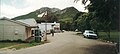
Rusape is a town in Zimbabwe.

The Honde Valley extends from the eastern border of Zimbabwe into Mozambique. The valley is part of the Eastern Highlands. The valley is about 130 kilometres from Mutare, or 110 kilometres from Nyanga. The Nyanga Mountains and the Nyanga National Park forms the western boundary of the valley.

Chimanimani, originally known as Melsetter, is a mountainous district in Manicaland Province of eastern Zimbabwe. The district headquarters is the town of Chimanimani.

Nyanga National Park lies in the north of Zimbabwe's Eastern Highlands. One of the first national parks to be declared in the country, it contains the highest land in Zimbabwe, with green hills and perennial rivers. Most of its terrain consists of rolling downland, sometimes lightly wooded, lying at altitudes between 1,800–2,593 metres. Mount Nyangani, the highest point in Zimbabwe, lies in the centre of the park and Mutarazi Falls, Zimbabwe's highest waterfall, is in the south of the park. Nyanga National park incorporates the former Mutarazi Falls National Park on its southern boundary.
Juliasdale is a resort town in Manicaland, Zimbabwe. It is situated in the foothills of the Nyanga mountains in eastern Zimbabwe
Lion's Den is a small town in Zimbabwe.
Plumtree is a town in Zimbabwe. Alongside marula trees, wild plum trees grow abundantly in area. The town was once called Getjenge by baKalanga. Another name which is mainly used is Titji, meaning station and referring to the railway station which was operating in the area around 1897.

Kadoma, originally known as Gatooma, is a town in Zimbabwe.
Chinhoyi, originally known as Sinoia, is a city in central northern Zimbabwe in the Makonde District. It has a population of 90,800 and is primarily a college town, although it was originally founded as an Italian group settlement scheme. The nearby Chinhoyi Caves and national park are a popular attraction.

Mount Nyangani is the highest mountain in Zimbabwe at 2,592 metres or 8,504 feet. The mountain is located within Nyanga National Park in Nyanga District, about 110 km (68 mi) northwest of Mutare. The summit lies atop a small outcrop of rock around 40 metres or 130 feet above the surrounding area. The remainder of the peak is a broad moor of mainly rolling hills and plateau with an area of about 8 km2. The edges of this plateau then fall steeply to the east and west sides. The mountain vegetation is largely composed of heath around the summit plateau with evergreen forest along the wetter eastern slopes and grassland to the western side. Annual rainfall totals are high but long spells of dry weather occur during the winter period of May to August. Due to its relatively low altitude and tropical location, snow falls very rarely, last recorded in August 1935.

Filabusi is a town in the Matabeleland South Province of Zimbabwe. The town is the district capital of Insiza District and a service centre for the surrounding mining and farming areas.

Chimanimani, originally known as Melsetter, is a town in Zimbabwe.
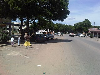
Chipinge, originally known as Chipinga, is a town in Zimbabwe, located in Chipinge District, in Manicaland Province, in southeastern Zimbabwe, close to the border with Mozambique.
Mutasa District is one of seven districts in Manicaland Province of Zimbabwe. Mutasa District is located 30 km northeast Mutare and stretches up to the Honde Valley, which is about 100 km northeast of Mutare along a tarred road that branches off the Nyanga road.
Nyanga District is located in Manicaland Province of Zimbabwe.
Murambinda is a town in Zimbabwe.
Mutare District is a district in Manicaland Province of eastern Zimbabwe. The district headquarters is the city of Mutare.