Oacoma, South Dakota

Last updated

Oacoma, South Dakota
Al's Oasis summer 2016 02.jpg
Downtown Oacoma
Motto: 
"One Day Just Isn't Enough"
Lyman County South Dakota Incorporated and Unincorporated areas Oacoma Highlighted.svg
Location in Lyman County and the state of South Dakota
Coordinates: 43°48′13″N99°22′20″W / 43.80361°N 99.37222°W / 43.80361; -99.37222
Country United States
State South Dakota
County Lyman
Founded1890 [1]
Area
[2]
  Total4.19 sq mi (10.86 km2)
  Land2.60 sq mi (6.75 km2)
  Water1.59 sq mi (4.11 km2)
Elevation
[3]
1,401 ft (427 m)
Population
 (2020) [4]
  Total386
  Density148.23/sq mi (57.22/km2)
Time zone UTC-6 (Central (CST))
  Summer (DST) UTC-5 (CDT)
ZIP code
57365
Area code 605
FIPS code 46-46180 [5]
GNIS feature ID1267519 [3]
Website oacomasd.com

Oacoma is a town in Lyman County, South Dakota, United States. The population was 386 at the 2020 census. [6] Oacoma is located on the west bank of the Missouri River, across from Chamberlain.

Contents

History

Al's Oasis, a stopping-off place in Oacoma along Interstate 90 Al's Oasis.jpg
Al's Oasis, a stopping-off place in Oacoma along Interstate 90

On September 17, 1804, Lewis and Clark camped on the west bank of the Missouri River near American Island where Oacoma is now located. During the remainder of the 19th century the area was a stopping off place for explorers, fur traders and steamboat men. The township of Oacoma was laid out in 1891 as the county seat for the newly formed Lyman County; the seat was transferred to Kennebec in 1922. The Chicago, Milwaukee, St. Paul and Pacific Railroad arrived to Oacoma in 1905 [7] and Oacoma was known as a "banking post-village". [8] In the 21st century, it is a rest stop for travelers on Interstate 90.

Geography

According to the United States Census Bureau, the town has a total area of 4.18 square miles (10.83 km2), of which 2.59 square miles (6.71 km2) is land and 1.59 square miles (4.12 km2) is water. [9]

American Crow Creek, a tributary to the Missouri River, enters the river in Oacoma.

The town is located approximately halfway between Sioux Falls and Rapid City.

Demographics

Historical population
CensusPop.Note
1910 235
1920 224−4.7%
1930 167−25.4%
1940 19718.0%
1950 23117.3%
1960 31235.1%
1970 215−31.1%
1980 28934.4%
1990 36727.0%
2000 3906.3%
2010 45115.6%
2020 386−14.4%
U.S. Decennial Census [10] [4]

2010 census

As of the census [11] of 2010, there were 451 people, 205 households, and 135 families residing in the town. The population density was 174.1 inhabitants per square mile (67.2/km2). There were 236 housing units at an average density of 91.1 per square mile (35.2/km2). The racial makeup of the town was 88.9% White, 0.2% African American, 6.4% Native American, 0.4% Asian, 0.7% from other races, and 3.3% from two or more races. Hispanic or Latino of any race were 1.8% of the population.

There were 205 households, of which 27.8% had children under the age of 18 living with them, 52.7% were married couples living together, 8.3% had a female householder with no husband present, 4.9% had a male householder with no wife present, and 34.1% were non-families. 30.2% of all households were made up of individuals, and 9.3% had someone living alone who was 65 years of age or older. The average household size was 2.20 and the average family size was 2.64.

The median age in the town was 44.3 years. 19.7% of residents were under the age of 18; 7.4% were between the ages of 18 and 24; 24.1% were from 25 to 44; 33.4% were from 45 to 64; and 15.3% were 65 years of age or older. The gender makeup of the town was 52.5% male and 47.5% female.

2000 census

As of the census [5] of 2000, there were 390 people, 169 households, and 111 families residing in the town. The population density was 192.8 inhabitants per square mile (74.4/km2). There were 188 housing units at an average density of 92.9 per square mile (35.9/km2). The racial makeup of the town was 94.36% White, 3.33% Native American, and 2.31% from two or more races. Hispanic or Latino of any race were 0.26% of the population.

There were 169 households, out of which 33.1% had children under the age of 18 living with them, 50.9% were married couples living together, 9.5% had a female householder with no husband present, and 34.3% were non-families. 29.0% of all households were made up of individuals, and 8.3% had someone living alone who was 65 years of age or older. The average household size was 2.31 and the average family size was 2.86.

In the town, the population was spread out, with 26.2% under the age of 18, 5.4% from 18 to 24, 30.3% from 25 to 44, 27.7% from 45 to 64, and 10.5% who were 65 years of age or older. The median age was 38 years. For every 100 females, there were 107.4 males. For every 100 females age 18 and over, there were 102.8 males.

The median income for a household in the town was $36,719, and the median income for a family was $44,250. Males had a median income of $26,500 versus $18,750 for females. The per capita income for the town was $17,206. About 8.4% of families and 7.4% of the population were below the poverty line, including 8.7% of those under age 18 and 16.7% of those age 65 or over.

Related Research Articles

<span class="mw-page-title-main">Alice, North Dakota</span> City in North Dakota, United States

Alice is a city in Cass County, North Dakota, United States. The population was 41 at the 2020 census.

<span class="mw-page-title-main">Wolsey, South Dakota</span> Town in South Dakota, United States

Wolsey is a town in Beadle County, South Dakota, United States. The population was 459 at the 2020 census.

<span class="mw-page-title-main">Tabor, South Dakota</span> Town in South Dakota, United States

Tabor is a town in Bon Homme County, South Dakota, United States. The population was 407 at the 2020 census.

<span class="mw-page-title-main">Bradley, South Dakota</span> Town in South Dakota, United States

Bradley is a town in Clark County, South Dakota, United States. The population was 65 at the 2020 census.

<span class="mw-page-title-main">Florence, South Dakota</span> Town in South Dakota, United States

Florence is a town in northwestern Codington County, South Dakota, United States. It is part of the Watertown, South Dakota Micropolitan Statistical Area. The population was 337 at the 2020 census.

<span class="mw-page-title-main">Toronto, South Dakota</span> Town in South Dakota, United States

Toronto is a town in Deuel County, South Dakota, United States. The population was 196 at the 2020 census.

<span class="mw-page-title-main">Onaka, South Dakota</span> Town in South Dakota, United States

Onaka is a town in Faulk County, South Dakota, United States. The population was 13 at the 2020 census.

<span class="mw-page-title-main">Stockholm, South Dakota</span> Town in South Dakota, United States

Stockholm is a town in Grant County, South Dakota, United States. The population was 102 at the 2020 census.

<span class="mw-page-title-main">Strandburg, South Dakota</span> Town in South Dakota, United States

Strandburg is a town in southern Grant County, South Dakota, United States. The population was 63 at the 2020 census. Its name is derived from the town's founder, the Swedish John Strandburg.

<span class="mw-page-title-main">Parkston, South Dakota</span> City in South Dakota, United States

Parkston is a city in Hutchinson County, South Dakota, United States. The population was 1,567 at the 2020 census.

<span class="mw-page-title-main">Whitewood, South Dakota</span> City in South Dakota, United States

Whitewood is a city in Lawrence County, South Dakota, United States. The population was 879 at the 2020 census.

<span class="mw-page-title-main">Hudson, South Dakota</span> Town in South Dakota, United States

Hudson is a town in Lincoln County, South Dakota, United States. The population was 311 at the 2020 census. It is the easternmost community in South Dakota.

<span class="mw-page-title-main">Langford, South Dakota</span> Town in South Dakota, United States

Langford is a town in Marshall County, South Dakota, United States. The population was 283 at the 2020 census.

<span class="mw-page-title-main">Crooks, South Dakota</span> City in South Dakota, United States

Crooks is a city in Minnehaha County, South Dakota, United States and is a suburb of Sioux Falls. The population was 1,362 at the 2020 census. Crooks was named New Hope until 1904. The town's present name honors W. A. Crooks, a local politician.

<span class="mw-page-title-main">Wall, South Dakota</span> Town in South Dakota, United States

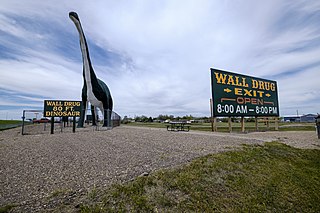
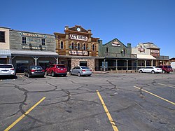
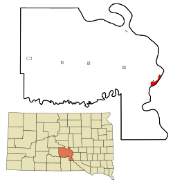
Wall is a town in Pennington County, South Dakota, United States. The population was 699 at the 2020 census.

<span class="mw-page-title-main">Corona, South Dakota</span> Town in South Dakota, United States

Corona is a town in Roberts County, South Dakota, United States. The population was 69 at the 2020 census.

<span class="mw-page-title-main">Ortley, South Dakota</span> Town in South Dakota, United States

Ortley is a town in Roberts County, South Dakota, United States. The population was 50 according to the 2020 census.

<span class="mw-page-title-main">Tulare, South Dakota</span> Town in South Dakota, United States

Tulare is a town in Spink County, South Dakota, United States. The population was 211 at the 2020 census.

<span class="mw-page-title-main">Davis, South Dakota</span> Town in South Dakota, United States

Davis is a town in Turner County, South Dakota, United States. The population was 54 at the 2020 census.

<span class="mw-page-title-main">Lowry, South Dakota</span> Town in South Dakota, United States

Lowry is a town in Walworth County, South Dakota, United States. The population was 10 at the 2020 census. The town is home to Lowry Pilgrim Community Church, Swan Creek Harness Shop, J & C Repair, Karst Service and a fire station. Lowry also has an abandoned school, and a post office, which closed to service in the early 1970s.

References

  1. "SD Towns" (PDF). South Dakota State Historical Society . Retrieved February 14, 2010.
  2. "ArcGIS REST Services Directory". United States Census Bureau. Retrieved October 15, 2022.
  3. 1 2 U.S. Geological Survey Geographic Names Information System: Oacoma, South Dakota
  4. 1 2 "Census Population API". United States Census Bureau. Retrieved October 15, 2022.
  5. 1 2 "U.S. Census website". United States Census Bureau . Retrieved January 31, 2008.
  6. "U.S. Census Bureau: Oacoma town, South Dakota". www.census.gov. United States Census Bureau. Retrieved December 28, 2021.
  7. Hellmann, Paul T. (May 13, 2013). Historical Gazetteer of the United States. Routledge. p. 994. ISBN   978-1135948597 . Retrieved November 30, 2013.
  8. Angelo Heilprin, ed. (1906). Lippincott's New Gazetteer: A Complete Pronouncing Gazetteer Or Geographical Dictionary of the World, Containing the Most Recent and Authentic Information Respecting the Countries, Cities, Towns ... in Every Portion of the Globe. Louis Heilprin. J.B. Lippincott Company. p. 1341. Retrieved December 15, 2014.
  9. "US Gazetteer files 2010". United States Census Bureau. Archived from the original on July 2, 2012. Retrieved June 21, 2012.
  10. "Census of Population and Housing". Census.gov. Retrieved June 4, 2015.
  11. "U.S. Census website". United States Census Bureau . Retrieved June 21, 2012.