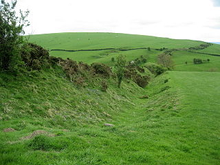
Offa's Dyke is a large linear earthwork that roughly follows the border between England and Wales. The structure is named after Offa, the Anglo-Saxon king of Mercia from AD 757 until 796, who is traditionally believed to have ordered its construction. Although its precise original purpose is debated, it delineated the border between Anglian Mercia and the Welsh kingdom of Powys.

Offa's Dyke Path is a long-distance footpath loosely following the Wales–England border. Officially opened on 10 July 1971, by Lord Hunt, it is one of Britain's National Trails and draws walkers from throughout the world. About 60 miles (97 km) of the 177-mile (285 km) route either follows, or keeps close company with, the remnants of Offa's Dyke, an earthwork traditionally thought to have been constructed in the late 8th century on the orders of King Offa of Mercia.

Oswestry is a market town, civil parish and historic railway town in Shropshire, England, close to the Welsh border. It is at the junction of the A5, A483 and A495 roads.

Wrexham is a city and the administrative centre of Wrexham County Borough in Wales. It is located between the Welsh mountains and the lower Dee Valley, near the border with Cheshire in England. Historically in the county of Denbighshire, and later the county of Clwyd in 1974, it has been the principal settlement of Wrexham County Borough since 1996.

Chirk is a town and community in Wrexham County Borough, Wales, 10 miles south of Wrexham, between it and Oswestry. At the 2011 census, it had a population of 4,468. Historically in the traditional county of Denbighshire, and later Clwyd, it has been part of Wrexham County Borough since a local government reorganisation in 1996. The border with the English county of Shropshire is immediately south of the town, on the other side of the River Ceiriog.

Wrexham County Borough is a county borough, with city status, in the north-east of Wales. It borders the English ceremonial counties of Cheshire and Shropshire to the east and south-east respectively, Powys to the south-west, Denbighshire to the west and Flintshire to the north-west. The city of Wrexham is the administrative centre. The county borough is part of the preserved county of Clwyd.

Ruabon is a village and community in Wrexham County Borough, Wales. The name comes from Rhiw Fabon, rhiw being the Welsh word for "slope" or "hillside" and Fabon being a mutation from St Mabon, the original church name, of earlier, Celtic origin. An older English spelling, Rhuabon, can sometimes be seen.

Overton or Overton-on-Dee is a village and community in Wrexham County Borough, Wales. It is situated close to the Welsh-English border on the edge of an escarpment that winds its way around the course of the River Dee, from which Overton-on-Dee derives its name.

Coedpoeth is a village and community in Wrexham County Borough, Wales. The built-up area with Minera had a population of 5,723 in the 2011 census.

Chirk Castle is a Grade I listed castle located in Chirk, Wrexham County Borough, Wales. It is now owned and run by the National Trust.

Erddig Hall is a Grade-I listed National Trust property near Wrexham, North Wales. Standing 2 miles (3.2 km) south of the city centre, it comprises a country house built, during the 17th and 18th centuries, amidst a 1,900-acre (770 ha) estate, which includes a 1,200-acre (490 ha) landscaped pleasure park and the earthworks of a Norman motte-and-bailey castle.

Brymbo is a village and community in Wrexham County Borough, Wales. It lies in the hilly country to the west of Wrexham city, largely surrounded by farmland.
Maelor Way is a key long distance footpath, running 38 kilometres / 24 miles from the Offa's Dyke Path National Trail at Bronygarth to the Shropshire Way, Sandstone Trail, Llangollen Canal, South Cheshire Way, and the Marches Way all at Grindley Brook near Whitchurch.
The city of Wrexham in north-east Wales has a history dating back to ancient times. The former market town was the site of heavy industry in the 19th and 20th centuries, and is now an active commercial centre. Wrexham was granted city status in 2022.
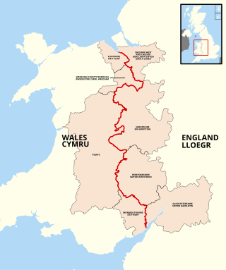
The England–Wales border, sometimes referred to as the Wales–England border or the Anglo-Welsh border, runs for 160 miles (260 km) from the Dee estuary, in the north, to the Severn estuary in the south, separating England and Wales.

The Battle of Crogen is an engagement said to have taken place in Wales during Henry II of England's summer 1165 campaign against an alliance of Welsh kingdoms led by King of Gwynedd, Owain Gwynedd. Later Welsh chronicles recorded that a detachment of Welsh troops inflicted a number of casualties on the Anglo-Norman army in the Ceiriog Valley; Henry subsequently abandoned the campaign after an attempt to cross the Berwyn Mountains was thwarted by severe weather.

Offa is a community and electoral ward in Wrexham County Borough, Wales, covering most of the south-western portion of the city of Wrexham. It is bordered by the communities of; Rhosddu, and Caia Park to the north, Abenbury to the east, Esclusham, and Marchwiel to the south, and Broughton, Coedpoeth, and Gwersyllt to the west.

Tregeiriog is a village in Wrexham County Borough, Wales. It is in the community of Ceiriog Ucha on the B4500 road between Glyn Ceiriog and Llanarmon Dyffryn Ceiriog.
The Buttington Oak was a tree near to Offa's Dyke at Buttington, Wales, said to have been planted to mark the site of the Battle of Buttington between the Vikings and a Mercian, Wessex and Welsh force in 893. It had been cyclically pollarded for timber until around 150 years ago. The oak tree was rediscovered in 2009. In 2017 it was badly damaged by storms, finally collapsing in February 2018. The Buttington Yew, also planted in commemoration of the battle in 893, survives and in 2022 was added to the roster of 70 Ancient Trees in The Queen's Green Canopy.
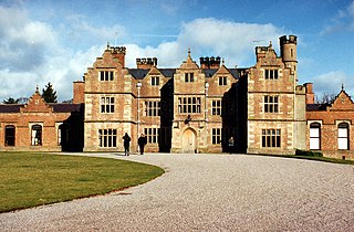
Brynkinalt Hall is a Grade-II* listed private property, built in 1612, near Chirk, Wrexham County Borough, Wales. The hall is surrounded by an estate including 1,000 acres (4.0 km2) of agricultural land and 400 acres (1.6 km2) of woodland. Part of the estate extends into Shropshire, England. Brynkinalt Park is a park located to the hall's north-west.


