
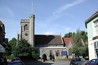
Hatfield is a town and civil parish in Hertfordshire, England, in the borough of Welwyn Hatfield. It had a population of 29,616 in 2001, and 39,201 at the 2011 Census. The settlement is of Saxon origin. Hatfield House, home of the Marquess of Salisbury, forms the nucleus of the old town. From the 1930s when de Havilland opened a factory until the 1990s when British Aerospace closed it, aircraft design and manufacture employed more people there than any other industry. Hatfield was one of the post-war New Towns built around London and has much modernist architecture from the period. The University of Hertfordshire is based there.
Hertfordshire is one of the home counties in southern England. It borders Bedfordshire and Cambridgeshire to the north, Essex to the east, Greater London to the south, and Buckinghamshire to the west. For government statistical purposes, it forms part of the East of England region.

Welwyn Garden City is a town in Hertfordshire, England, 20 miles (32 km) north of London. It was the second garden city in England and one of the first new towns. It is unique in being both a garden city and a new town and exemplifies the physical, social and cultural planning ideals of the periods in which it was built.
Welwyn is a village and civil parish in Hertfordshire, England. The parish also includes the villages of Digswell and Oaklands. It is sometimes referred to as Old Welwyn or Welwyn Village, to distinguish it from the much newer and larger settlement of Welwyn Garden City, about a mile to the south.

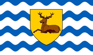
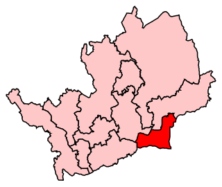
Welwyn Hatfield is a constituency in Hertfordshire represented in the House of Commons of the UK Parliament since 2005 by Grant Shapps, the Secretary of State for Business, Energy and Industrial Strategy, a Conservative who was previously the Secretary of State for Transport.
Broxbourne is a constituency in Hertfordshire represented in the House of Commons of the UK Parliament since 2005 by Charles Walker of the Conservative Party.

Datchworth is a village and civil parish between the towns of Hertford, Stevenage and Welwyn Garden City in the county of Hertfordshire, England. Sited on the Roman road from St Albans to Puckeridge, the village has examples of Saxon clearings in several locations. Datchworth has a village green where there are two pubs and a sports club. There are three other pubs in the parish: The Horns at Bulls Green, The White Horse at Burnham Green and Three Horse Shoes at Hooks Cross. In the 2001 Census the population was 1,065, increasing to 1,524 at the 2011 Census.

Ayot St Peter is a village and civil parish in the Welwyn Hatfield district of Hertfordshire, England, about two miles north-west of Welwyn Garden City. According to the 2001 census it had a population of 166. At the 2011 Census the population including the nearby Ayot Green and Ayot St Lawrence was 245.

Welwyn Garden City Football Club is a football club based in Welwyn Garden City, Hertfordshire. They currently play in the Southern League Division One Central.

Northaw and Cuffley is a civil parish in the Welwyn Hatfield borough of Hertfordshire, England. Located approximately 13.5 miles (21.7 km) north of central London and adjacent to the Greater London boundary, it is a partly urbanised parish with large sections of open land. Northaw and Cuffley is a recent renaming of the ancient parish of Northaw, covering the settlements of Northaw and Cuffley. The local council is Northaw and Cuffley Parish Council.
Oaklands College is a further education college in Hertfordshire, United Kingdom. It was established in 1991 when further education was reorganised. The college has campuses in St Albans and Welwyn Garden City, with a further provision in Borehamwood. Over 10,000 students study at the college annually, studying full time, part time and higher education courses as well as apprenticeships.

Digswell is an ancient village and former parish in the English county of Hertfordshire which is recorded in the 1086 Domesday Book. The population of the urban area of Digswell in the 2011 Census was 1,632.
The New QEII Hospital is located in Welwyn Garden City and managed by East and North Hertfordshire NHS Trust.
One third of Welwyn Hatfield Borough Council in Hertfordshire, England is elected each year, followed by one year without election. Since the last boundary changes in 2008, 48 councillors have been elected from 16 wards.

Hertfordshire was a constituency of the European Parliament located in the United Kingdom, electing one Member of the European Parliament by the first-past-the-post electoral system. Created in 1979 for the first elections to the European Parliament, it was abolished in 1999 on the adoption of proportional representation for European elections in the United Kingdom. It was succeeded by the East of England region.
Welwyn is a special service area in the Rural Municipality of Moosomin No. 121, Saskatchewan, Canada that held village status prior to May 2018. It is located in the southeastern portion of Saskatchewan, near the Manitoba border. The community was named for Welwyn, in Hertfordshire, England at the suggestion of James Wake, who homesteaded just across the Manitoba border. In 2016, the population was 133.

The county of Hertfordshire is divided into ten districts. The districts of Hertfordshire are Three Rivers, Watford, Hertsmere, Welwyn Hatfield, Broxbourne, East Hertfordshire, Stevenage, North Hertfordshire, St Albans, and Dacorum.

Templewood Primary School is a primary school in Pentley Park, Welwyn Garden City, Hertfordshire, England. It is one of a number of modernist schools commissioned by the Hertfordshire County Council in the 20th century and is a Grade II* listed building.

