Ocean Falls

Last updated

Ocean Falls
Community
Downtown Ocean Falls, BC.jpg
Ocean Falls waterfront in June 2009
Canada British Columbia location map 2.svg
Red pog.svg
Ocean Falls
Coordinates: 52°21′05″N127°41′30″W / 52.35139°N 127.69167°W / 52.35139; -127.69167
Country Canada
Province British Columbia
Regional District Central Coast
Population
  TotalAbout 50
Demonym Rain People
Time zone UTC-8 (Pacific Standard (PST))
  Summer (DST) UTC-7 (PDT)
Postal code span
V0T 1P0
Area code 250

Ocean Falls is a community on the Central Coast of British Columbia, Canada. Formerly a large company town [1] owned by Crown Zellerbach, it is accessible only via boat or seaplane, and is home for a few dozen full-time residents, with the seasonal population upwards of 100.

Contents

Geography and environment

An uncharacteristically sunny day in Ocean Falls Ocean falls view.jpg
An uncharacteristically sunny day in Ocean Falls

Ocean Falls is noted for its abundance of rain - about 4,390 millimetres (172.8 in) annually, and its residents are sometimes referred to as the "Rain People". [2] [3] Situated around a waterfall from Link Lake straight into Cousins Inlet, it has considerable energy resources that are largely untapped.

History

The Heiltsuk native speaking people and the Nuxalk native speaking people inhabited the coastal region surrounding Ocean Falls for more than 9,000 years. In 1903, the Bella Coola Pulp and Paper Company surveyed the area and was impressed with the hydro power potential of the site. In 1906, following the company's acquisition of 260 acres (1.1 km2) of land, clearing began for the town and three years later, a sawmill, hospital and school were established. In 1912, the dam was erected and the pulp mill began operating. [4] The Ocean Falls pulp and paper mill was the largest mill in British Columbia for many years. The mill produced mechanical, sulfite and sulphate pulp processed on two newsprint machines, two kraft paper machines and one tissue machine. Much of the electrical power for the mill and town was produced by four hydro turbines.

Ocean Falls' population numbered 250 in 1912 and grew to 3,500 by 1950. By 1970, the number of inhabitants had dropped to 1,500. Only about 70 people, mostly loggers, remained by 1990.

The profit structure of the original investment changed considerably during the mill's many years of operation. Low labour costs, inexpensive hydro power and low infrastructure costs made the Ocean Falls mill a viable proposition. Nevertheless, the remote location, rising labour costs and the high cost of operating a town site made further investment unattractive. The Ocean Falls pulp and paper mill was a very large and complex production facility and modernization costs were prohibitive.

By the early 1970s, the facility was inefficient and uneconomical. The owner at that time, Crown Zellerbach, decided to close the plant and effectively shut down the town by March 1973. The provincial government bought the town and mill at a minimal cost a few weeks before the planned closure and kept the mill operating until 1980. The Ocean Falls mill thus joined the ranks of other older, remote pulp and paper mills in British Columbia shut down during the latter part of the twentieth century.

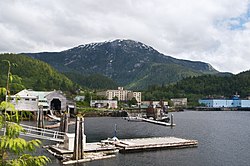
Today, much of the town has been demolished, and many of the remaining buildings are in decay. Nevertheless, Ocean Falls maintains a residential community and a social network of former residents.

Several disasters have struck the town. A major apartment fire in 1950 killed eight, [5] a mudslide in 1965 killed seven and the town's Charleson school burned down on the night between December 21 and 22, 1969. [3] Although no one was seriously hurt in the school fire, the little community was traumatized nevertheless. The school was closed for only three days; several teachers went to Bella Bella to obtain school desks and classes were held throughout the community, from the community centre to the Royal Canadian Legion branch pub (grade 12 students) to part of the Martin Inn, a 600-bed hotel. The new school, with one of the largest indoor gymnasiums in British Columbia, opened in 1971. [3]

Economy and infrastructure

At its largest, Ocean Falls was the home to around 3900 people, a K-12 school system, its own hospital, one of the province's largest hotels and a swimming pool where several swimming champions trained.

Ocean Falls was a typical single-employer town where the company operated and maintained the complete town site. A town site manager, working in a town site office, managed the allocation of apartments and houses on behalf of the people living in town. Utilities such as water, electricity, and heat were subsidized by the company. The rental cost of accommodation was also quite reasonable permitting the residents of Ocean Falls to live rather inexpensively. In the nearby Martin Valley, residents could purchase their own single-family houses. However, in most cases the company offered a buy-back option to protect the purchaser.

The 400-room Martin Inn in 1990, two years after it closed Martin Inn Ocean Falls.jpg
The 400-room Martin Inn in 1990, two years after it closed

The town consisted of a blend of fairly large apartments, duplexes and single-family homes. Most of the buildings were located on the fairly steep slope of the Caro Marion mountain. The town's main store and several other smaller businesses were located along the harbour front. The Ocean Falls Court House, the Legion Hall, the Royal Canadian Mounted Police building and the Post office are also in the harbour area. Most of the roads leading up the hills away from the harbour area were heavily constructed timber roads. These roads were capable of carrying large vehicles such as trucks or fire engines. There were very few cars in town and usually only one taxi cab. Most of the cars were owned by people who lived in Martin Valley.

The harbour was well protected from most wind directions and there was plenty of dock space for local as well as visiting boaters. The harbour was kept dredged so that deep sea ships could tie up at the mill's paper warehouses. There were float planes arriving and departing every day. Larger amphibious planes such as Grumman Goose and Mallards were flying passengers in from Vancouver and other larger settlements. The town was also served by freighters which would bring in supplies from Vancouver.

The only cruise ship that ever called at Ocean Falls was Holland America's SS Rotterdam on May 18, 1997. The ship was chartered by a British Columbia tour operator, Wells Gray Tours. The town had only 50 residents, but they successfully hosted 1,100 visitors. There was hope that other Alaska-bound cruise ships would start to visit Ocean Falls, but it never happened. [3] On October 6, 2019, the 400-passenger MV Seabourn Sojourn cruised off Oceans Falls in an unexpected visit when its planned day in Klemtu, British Columbia, was cancelled due to weather, but no-one went ashore.

There is a sign on the road that reads "July 13, 1929, Give to the world the best you have and the best will come back to you - Willy Buttner".

The town is now home to a Bitcoin mining operation due to the availability of electricity that would otherwise not be utilized. After the shut down of the pulp mill, only one third of the privately owned dam's power capacity was in use, as this is all that was needed by the powered communities of Ocean Falls, Shearwater, and Bella Bella. [6] There are no power lines connecting the dam to the North American power grid, thus no opportunity to sell power to anywhere other than local communities.

Notable residents

Climate

Climate data for Ocean Falls
MonthJanFebMarAprMayJunJulAugSepOctNovDecYear
Record high °C (°F)15.0
(59.0)
16.1
(61.0)
20.6
(69.1)
25.0
(77.0)
32.2
(90.0)
35.6
(96.1)
35.6
(96.1)
39.4
(102.9)
32.2
(90.0)
22.8
(73.0)
17.2
(63.0)
14.0
(57.2)
39.4
(102.9)
Mean daily maximum °C (°F)3.2
(37.8)
5.2
(41.4)
7.0
(44.6)
9.9
(49.8)
14.0
(57.2)
17.2
(63.0)
19.5
(67.1)
19.8
(67.6)
16.8
(62.2)
11.7
(53.1)
6.4
(43.5)
3.8
(38.8)
11.2
(52.2)
Daily mean °C (°F)1.1
(34.0)
2.8
(37.0)
4.1
(39.4)
6.3
(43.3)
9.8
(49.6)
13.2
(55.8)
15.6
(60.1)
16.2
(61.2)
13.7
(56.7)
9.2
(48.6)
4.3
(39.7)
1.8
(35.2)
8.2
(46.7)
Mean daily minimum °C (°F)−1.1
(30.0)
0.4
(32.7)
1.0
(33.8)
2.7
(36.9)
5.6
(42.1)
9.2
(48.6)
11.6
(52.9)
12.4
(54.3)
10.5
(50.9)
6.8
(44.2)
2.3
(36.1)
−0.3
(31.5)
5.1
(41.2)
Record low °C (°F)−18.3
(−0.9)
−15.0
(5.0)
−16.7
(1.9)
−5.0
(23.0)
−7.2
(19.0)
1.1
(34.0)
3.9
(39.0)
2.2
(36.0)
1.1
(34.0)
−17.8
(0.0)
−20.0
(−4.0)
−17.8
(0.0)
−20.0
(−4.0)
Average precipitation mm (inches)512.4
(20.17)
409.9
(16.14)
323.6
(12.74)
318.2
(12.53)
238.1
(9.37)
195.8
(7.71)
155.5
(6.12)
197.9
(7.79)
366.0
(14.41)
587.8
(23.14)
492.4
(19.39)
503.2
(19.81)
4,300.8
(169.32)
Average snowfall cm (inches)63.7
(25.1)
30.5
(12.0)
11.1
(4.4)
2.1
(0.8)
0.0
(0.0)
0.0
(0.0)
0.0
(0.0)
0.0
(0.0)
0.0
(0.0)
1.7
(0.7)
11.9
(4.7)
34.0
(13.4)
155
(61.1)
Average precipitation days20.018.020.019.018.016.013.014.017.022.021.020.0218
Source: Environment and Climate Change Canada [7]

Related Research Articles

<span class="mw-page-title-main">Kapuskasing</span> Town in Ontario, Canada

Kapuskasing is a town on the Kapuskasing River in the Cochrane District of Northern Ontario, Canada, approximately 92 kilometres (57 mi) east of Hearst and 130 kilometres (81 mi) northwest of Timmins. The town was known as MacPherson until 1917, when the name was changed so as not to conflict with another railway stop in Manitoba.

<span class="mw-page-title-main">Liverpool, Nova Scotia</span> Community in Nova Scotia, Canada

Liverpool is a Canadian community and former town located along the Atlantic Ocean of the Province of Nova Scotia's South Shore. It is situated within the Region of Queens Municipality which is the local governmental unit that comprises all of Queens County, Nova Scotia.

<span class="mw-page-title-main">Port Alberni</span> City in British Columbia, Canada

Port Alberni is a city located on Vancouver Island in the province of British Columbia, Canada. The city lies within the Alberni Valley at the head of the Alberni Inlet, Vancouver Island's longest inlet. It is the location of the head offices of the Alberni-Clayoquot Regional District. Port Alberni currently has a total population of 18,259.

Grand Falls-Windsor is a town located in the central region of the island of Newfoundland in the province of Newfoundland and Labrador, Canada, with a population of 13,853 at the 2021 census. The town is the largest in the central region, the sixth largest in the province, and is home to the annual Exploits Valley Salmon Festival. Grand Falls-Windsor was incorporated in 1991, when the two former towns of Grand Falls and Windsor amalgamated.

<span class="mw-page-title-main">Shawinigan</span> City in Quebec, Canada

Shawinigan is a city located on the Saint-Maurice River in the Mauricie area in Quebec, Canada. It had a population of 49,620 as of the 2021 Canadian census.

Mataura is a town in the Southland region of the South Island of New Zealand. Mataura has a meat processing plant, and until 2000 it was the site of a large pulp and paper mill.

<span class="mw-page-title-main">Spanish River (Ontario)</span> River in Ontario, Canada

The Spanish River is a river in Algoma District, Sudbury District and Greater Sudbury in Northeastern Ontario, Canada. It flows 338 kilometres (210 mi) in a southerly direction from its headwaters at Spanish Lake and Duke Lake to its mouth at the North Channel of Lake Huron just outside the community of Spanish.

<span class="mw-page-title-main">Botwood</span> Town in Newfoundland and Labrador, Canada

Botwood is a town in north-central Newfoundland, Newfoundland and Labrador, Canada in Census Division 6. It is positioned on the west shore of the Bay of Exploits on a natural deep-water harbour. Historically, this harbour has been a significant hub for cargo ships and seaplanes. Botwood served as the North American endpoint for the first transatlantic commercial flights.

<span class="mw-page-title-main">Gold River, British Columbia</span> Village in British Columbia, Canada

Gold River is a village municipality located close to the geographic centre of Vancouver Island in British Columbia, Canada. In terms of the Island's human geography it is considered to be part of the "North Island", even though it technically is on the Island's west coast.

<span class="mw-page-title-main">Terrace Bay</span> Township in Ontario, Canada

Terrace Bay is a township in Thunder Bay District in northern Ontario, Canada, located on the north shore of Lake Superior east of Thunder Bay along Highway 17. The name originates from a series of lake terraces formed as the water level in Lake Superior lowered following the latest ice age.

<span class="mw-page-title-main">Mackenzie, British Columbia</span> District municipality in British Columbia, Canada

Mackenzie is a district municipality within the Fraser-Fort George Regional District in central British Columbia, Canada. The community is located at the south end of Williston Lake. The townsite, established by Alexandra Forest Industries and Cattermole Timber, was named for Sir Alexander MacKenzie (1764–1820).

<span class="mw-page-title-main">Chetwynd, British Columbia</span> District municipality in British Columbia, Canada

Chetwynd is a district municipality located in the eastern foothills of the Rocky Mountains, in northeastern British Columbia, Canada. Situated on an ancient floodplain, it is the first town eastbound travellers encounter after emerging from the Rockies along Highway 97, and acts as the gateway to the Peace River Country. The town developed during the construction of infrastructure through the Rocky Mountains in the 1950s; additionally, it was used as a transshipment point during the building of hydroelectric dams, in the 1960s and 1970s, and the new town of Tumbler Ridge, in the early 1980s. Home to approximately 2,600 residents, the town’s population has increased little—if at all—since the 1980s, but is significantly younger than the provincial average.

<span class="mw-page-title-main">Howe Sound</span> Sound in British Columbia, Canada

Howe Sound is a roughly triangular sound, that joins a network of fjords situated immediately northwest of Vancouver, British Columbia, Canada. It was designated as a UNESCO Biosphere Reserve in 2021.

<span class="mw-page-title-main">Bella Coola, British Columbia</span> Town in British Columbia, Canada

Bella Coola is an unincorporated community in the Bella Coola Valley of British Columbia, Canada. Bella Coola usually refers to the entire valley, encompassing the settlements of Bella Coola proper, Lower Bella Coola, Hagensborg, Salloompt, Nusatsum, Firvale, and Stuie. It is also the location of the head offices of the Central Coast Regional District.

<span class="mw-page-title-main">Catalyst Paper</span> Canadian pulp and paper company

Catalyst Paper Corporation is a pulp and paper company based in Richmond, British Columbia. It operates five pulp mills and paper mills, producing a combined 1.8 million tonnes of paper and 491,000 tonnes of market pulp annually. The mills mostly produce magazine paper and newsprint.

<span class="mw-page-title-main">Sheet Harbour, Nova Scotia</span> Place in Nova Scotia, Canada

Sheet Harbour is a rural community in Nova Scotia, Canada. It is located in the eastern reaches of the Halifax Regional Municipality, approximately 117 km (73 mi) northeast of the central urban area of the municipality, concentrated on Downtown Halifax and Dartmouth. The community is located along the Marine Drive scenic route on Trunk 7 at its junctions with Route 224 and Route 374. Surrounding the branched harbour which its name is derived from, the community has a population of about 800 and its respective census tract, containing sizable amounts of land around the community, has a population of 3,478 as of the 2011 Census. Two rivers, West River and East River, flow through the community and into the Northwest and Northeast Arms of the harbour respectively. The coastline of the community is heavily eroded and the region in which the community is located has an abundance of lakes. The region has a humid continental climate, congruent with the majority of Nova Scotia, and the ocean significantly influences the temperature.

<span class="mw-page-title-main">Ear Falls</span> Township in Ontario, Canada

Ear Falls is a township located in Northwestern Ontario, Canada, on the banks of the English River, Lac Seul, Pakwash Lake and Wenesaga Lake. It is located along Highway 105, 100 kilometres (62 mi) north of Highway 17 and Vermilion Bay, about halfway between Highway 17 and Red Lake, or about 480 kilometres (300 mi) northwest of Thunder Bay.

<span class="mw-page-title-main">Hugh J. Chisholm</span>

Hugh Joseph Chisholm I was a Canadian industrialist who later became a citizen of the United States. He was born in Chippawa, Canada West, to parents of Scottish ancestry. His early years as an entrepreneur in the news distribution business provided a foundation for his later accomplishments in the pulp and paper industry. His founding and leadership of pulp and paper, fibre-ware, and light and power companies as well as banks and railways made him a dominant figure in Maine industry. His legacy went beyond his reputation as a capitalist, however; he created the first forest management program for International Paper Company and developed a planned community for the workers in his mills which was a model for the nation.

<span class="mw-page-title-main">Crown Zellerbach</span> Defunct American pulp and paper conglomerate

Crown Zellerbach was an American pulp and paper conglomerate based in San Francisco, California, purchased in a hostile takeover in 1985. Most of its pulp and paper assets were sold to James River Corporation, now part of Georgia-Pacific.

Elk Falls Mill was a pulp mill and paper mill located in the Canadian town of Campbell River, British Columbia, operating between 1952 and 2010. At the end of its life, the mill had three paper machines, with a combined annual production of 373,000 tonnes of newsprint and 153,000 tonnes specialized papers.

References

  1. BC Names entry "Ocean Falls (community)"
  2. "WorldClimate.com" . Retrieved December 29, 2007.
  3. 1 2 3 4 Ramsey, Bruce (1997). Rain People: The Story of Ocean Falls, 2nd edition. Edited by Roland Neave. Publisher: Wells Gray Tours, Kamloops, BC. Copyright 1997 by Ocean Falls Public Library Association. ISBN   0-9681932-0-X.
  4. Ocean Falls Musimentary, Tont Papa
  5. Eight Lose Lives as Flames Raze 4-Story Ocean Falls Block. Vancouver Sun. March 7, 1950, p.1
  6. "The Bitcoin Boom Reaches a Canadian Ghost Town". Bloomberg News . Archived from the original on September 16, 2018.
  7. "Canadian Climate Normals 1961–1990 Station Data". Environment and Climate Change Canada . Retrieved June 3, 2024.