
This is a list of properties and historic districts in West Virginia that are listed on the National Register of Historic Places. There are listings in every one of West Virginia's 55 counties.

Buildings, sites, districts, and objects in Virginia listed on the National Register of Historic Places:

Cedar Creek and Belle Grove National Historical Park became the 388th unit of the United States National Park Service when it was authorized on December 19, 2002. The National Historical Park was created to protect several historically significant locations in the Shenandoah Valley of Northern Virginia, notably the site of the American Civil War Battle of Cedar Creek and the Belle Grove Plantation.

The boundary markers of the original District of Columbia are the 40 milestones that marked the four lines forming the boundaries between the states of Maryland and Virginia and the square of 100 square miles (259 km2) of federal territory that became the District of Columbia in 1801. Working under the supervision of three commissioners that President George Washington had appointed in 1790 in accordance with the federal Residence Act, a surveying team that Major Andrew Ellicott led placed these markers in 1791 and 1792. Among Ellicott's assistants were his brothers Joseph and Benjamin Ellicott, Isaac Roberdeau, George Fenwick, Isaac Briggs and an African American astronomer, Benjamin Banneker.

The Virginia Landmarks Register (VLR) is a list of historic properties in the Commonwealth of Virginia. The state's official list of important historic sites, it was created in 1966. The Register serves the same purpose as the National Register of Historic Places. The nomination form for any Virginia site listed on the VLR is sent forward to the National Park Service for consideration for listing on the National Register.
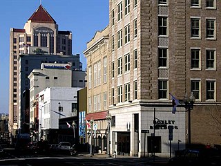
The Roanoke Downtown Historic District is a national historic district located in the Downtown Roanoke area of Roanoke, Virginia. It encompasses 122 contributing buildings. It includes a variety of commercial, institutional, social, and governmental buildings and structures from the late 19th century to the mid-20th century. Notable buildings include the Roanoke City Public Library, the YMCA Central Branch Building, First Christian Church (1925), the Central Church of the Brethren (1924), Tomnes Cawley Funeral Home (1928), Thomas B. Mason Building (1961), Peerless Candy Co., City Hall / Municipal Building (1915), Roanoke Times Building (1892), Anchor Building / Shenandoah Building (1910), Greene Memorial Methodist Church (1890), and United States Post Office and Courthouse (1930). Located in the district are the separately listed Patrick Henry Hotel, the Boxley Building, the Campbell Avenue Complex Historic District, Colonial National Bank, and First National Bank.

The Court House Hill–Downtown Historic District is a national historic district located in Lynchburg, Virginia. The area is situated on a promontory overlooking the Lower Basin Historic District on the south bank of the James River. The approximately 50-acre (200,000 m2) district is composed of relatively intact city blocks of religious, commercial, residential, and governmental buildings and structures ranging in date from the early 19th century to the mid-20th century. Buildings in the district represent a variety of styles from the different periods, including the Federal, Greek Revival, Gothic Revival, Italianate, Queen Anne, Neoclassical, Italian Renaissance, Spanish Eclectic, Craftsman, and Art Deco styles.

The Lower Basin Historic District is a national historic district located in Lynchburg, Virginia. The district defines a commercial and industrial warehouse area located between the downtown commercial area to the south and the James River waterfront to the north. The district contains a variety of mostly late 19th- and early 20th-century, multi-story, brick warehouses and factories, two-to-three-story brick commercial buildings, and a number of structures associated with the James River and Kanawha Canal and the Norfolk and Western and Chesapeake and Ohio Railways. The district is named for a wide basin of the canal that once extended between Ninth Street and Horseford Road, and contains 60 contributing buildings, two contributing structures, and one contributing object-a monument commemorating the site of 18th-century Lynch's Ferry.
This is a list of the National Register of Historic Places listings in Fredericksburg, Virginia.

Matthew Whaley School is a public elementary school located in Williamsburg, Virginia, occupying a historic school building. It is within the Williamsburg-James City County Public Schools.
The Taylorstown Historic District comprises the historic core of Taylorstown, Virginia. The community and the historic district are centered on the Taylorstown Mill, a two-story stone structure on the banks of Catoctin Creek. Up the hill from the mill is Hunting Hill, a house built in 1737 for the mill's owner. The district also includes a store built in 1800, adjoined by the 1904 Mann's Store, with the 1900 Mann house across the street.

Fairfield Farms is a historic estate house located near Berryville, Clarke County, Virginia. It was built in 1768, and designed by architect John Ariss and built for Warner Washington, first cousin to George Washington. During his surveying for Lord Fairfax, George Washington helped survey and layout the property for John Aris. It is a five-part complex with a 2+1⁄2-story hipped-roof central block having walls of irregular native limestone ashlar throughout. It is in the Georgian style. Located on the property are a contributing large brick, frame and stone barn and an overseer's house.
Walter Reed Birthplace is a historic home located near Belroi, Gloucester County, Virginia. It was built around 1825, and is a one-story, gable roofed frame dwelling. It has a rear shed addition. The house was restored in 1927 and again in 1970. It was the birthplace of Dr. Walter Reed.

Goochland County Court Square is a historic county courthouse and national historic district located at Goochland, Goochland County, Virginia. It includes three contributing buildings and one contributing site. The Goochland County Court House was built in 1826 by Dabney Cosby, an architect of the area. It is a two-story, temple-form brick structure with a projecting pedimented tetrastyle Tuscan order portico.

The Beadles House is a historic house located at 515 Greene Acres Road near Stanardsville, Greene County, Virginia. It was built from 1788 to 1789 by Revolutionary War militia captain John Beadles. It is a two-story, chestnut and poplar log dwelling. It was listed on the National Register of Historic Places on November 22, 2000.

Buckland Historic District is a national historic district located at Buckland, Prince William County, Virginia. It encompasses 30 contributing buildings, 11 contributing sites, and 6 contributing structures in the town of Buckland. The district is centered on a grist mill, Buckland Mill, the third such structure located on the site. Besides the mill, the most significant buildings include an early 19th-century wagon tavern and a small church. For the most part the houses are small, simple, 19th-century dwellings constructed of log, frame or stone; most were intended to serve a commercial as well as a residential purpose. Other contributing resources include the mill race and dam, Cerro Gordo plantation, portions of the Civil War Buckland battlefields, the Kinsley Mill and miller's house, and Buckland Hall.

Strasburg Stone and Earthenware Manufacturing Company, also known as the Strasburg Museum, Steam Pottery, and Southern Railroad Station, is a historic factory building located at Strasburg, Shenandoah County, Virginia. It was built in 1891, and is a two-story, 10 bay brick building originally constructed for the Strasburg Stone and Earthenware Manufacturing Company to make earthenware. It was converted to railroad use in 1913, at which time a one-story pent roof was added. The building is covered with a slate-clad hipped roof surmounted by a hipped monitor. The building served as a station and depot for the Southern Railroad.
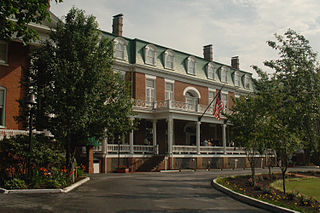
Abingdon Historic District is a national historic district located at Abingdon, Washington County, Virginia. The district encompasses 145 contributing buildings, 2 contributing site, and 13 contributing structures in the town of Abingdon. It includes a variety of residential, commercial, and institutional buildings dating from the late-18th century to the mid-20th century. Notable contributing resources include Sinking Spring Cemetery, William King High School (1913), General Francis Preston House (1832), Martha Washington Inn, Barter Theatre, the Virginia House, Alexander Findlay House (1827), Gabriel Stickley House, Ann Berry House, Washington County Courthouse (1868), Rev. Charles Cummings House, and James Fields House (1857). Located in the district and separately listed are the Abingdon Bank and Dr. William H. Pitts House.

Portsmouth Olde Towne Historic District, is a national historic district located at Portsmouth, Virginia. It encompasses 89 buildings. It is located in the primarily residential section of Portsmouth and includes a notable collection of Federal and Greek Revival style townhouses, known as "basement houses." Other notable buildings include the Watts House (1799), Grice-Neeley House, Ball-Nivison House (1752), Emanuel African Methodist Episcopal Church (1857), St. John's Episcopal Church (1898), Court Street Baptist Church (1901-1903), and Union Machinist Home. Located in the district is the separately listed Monumental Methodist Church.

The Main Street Banking Historic District is a national historic district located in downtown Richmond, Virginia. The district encompasses 19 contributing buildings located south of the Virginia State Capitol and west of the Shockoe Slip Historic District. It is the location of a number of buildings built for or occupied by banking institutions. The district includes representative examples of the Late Victorian and International Style architecture built between about 1865 and 1965. Notable buildings include the Virginia Employment Commission Building (1960), the 700 Building (1964), the Ross Building (1964), the Fidelity Building (1965). Located in the district is the separately listed First National Bank Building.


