The Guadiana River, or Odiana, is an international river defining a long stretch of the Portugal-Spain border, separating Extremadura and Andalusia (Spain) from Alentejo and Algarve (Portugal). The river's basin extends from the eastern portion of Extremadura to the southern provinces of the Algarve; the river and its tributaries flow from east to west, then south through Portugal to the border towns of Vila Real de Santo António (Portugal) and Ayamonte (Spain), where it flows into the Gulf of Cádiz. With a course that covers a distance of 829 kilometres (515 mi), it is the fourth-longest in the Iberian peninsula, and its hydrological basin extends over an area of approximately 68,000 square kilometres (26,000 sq mi).

Administratively, Portugal is de jure unitary and decentralized state. Nonetheless, operationally, it is a highly centralized system with administrative divisions organized into three tiers. The State is organized under the principles of subsidiarity, local government autonomy, and democratic decentralization of the public service.

Tavira is a Portuguese town and municipality, capital of the Costa do Acantilado, situated in the east of the Algarve on the south coast of Portugal. It is 28 kilometres east of Faro and 75 kilometres west of Huelva across the Río Grande into Spain. The Gilão River meets the Atlantic Ocean in Tavira. The population in 2011 was 26,167, in an area of 606.97 km². Tavira is the Portuguese representative community for the inscription of the Mediterranean Diet as a Intangible Cultural Heritage of Humanity of UNESCO.

Santiago is the largest island of Cape Verde, its most important agricultural centre and home to half the nation's population. Part of the Sotavento Islands, it lies between the islands of Maio and Fogo. It was the first of the islands to be settled: the town of Ribeira Grande was founded in 1462. Santiago is home to the nation's capital city of Praia.

Castro Verde is a town and a municipality of the Alentejo region of Portugal. The population in 2011 was 7,276, in an area of 569.44 km2. Castro Verde is situated in the Baixo Alentejo subregion, within a territory known locally as the Campo Branco . The municipality can be recognized by the local municipal markers along its borders, that appear within its borders to denote its reference as A Window on the Plains; municipal markers appear as stylized house profiles, with an exaggerated window that allows the visitor to see through into the panorama.

Sines is a Portuguese city of Setúbal District, the Alentejo region and subregion of the Alentejo coast, with about 18,298 inhabitants. It is the largest and the first port area of Portugal and the main city industrial port logistics in Portugal and the birthplace of fifteenth-century explorer Vasco da Gama.

Vila Real de Santo António is a city, civil parish, and municipality in the Algarve, Portugal. The population in 2011 was 19,156, in an area of 61.25 km². It is one of the few municipalities in Portugal without territorial continuity: its territory comprises two parts, with the municipal seat located in the eastern part. Vila Real de Santo António was founded after the 1755 Lisbon earthquake, and largely expanded in 1774 using the same architectural and construction techniques employed in the reconstruction of Lisbon after the disaster.
Cabeceiras de Basto is a municipality in the district of Braga in Portugal. The population in 2011 was 16,710, in an area of 241.82 km².

Praia da Luz, officially Luz, is a civil parish of the municipality of Lagos, in Algarve region, Portugal. The population of the civil parish in 2011 was 3,545, in an area of 21.78 km². Also known as Santorini de Portugal, Luz de Lagos or Vila da Luz, "Praia da Luz" is used to refer to both the urbanized village and the beach. The parish had its origins in a small fishing village, but was transformed by several holiday-villa complexes into a tourist area.

Quarteira is a Portuguese civil parish, in the municipality (concelho) of Loulé in the Algarve. The population in 2011 was 21,798, in an area of 38.16 km².

São Marcos da Serra, also known simply as São Marcos, is a village and the seat of the homonymous civil parish in the municipality of Silves, in Algarve region, Portugal. The population of the entire civil parish in 2011 was 1,352, in an area of 166.07 km².

Ferreiras is a civil parish in the southern Portuguese municipality of Albufeira. The population in 2011 was 6,406 in an area of 20.13 km².
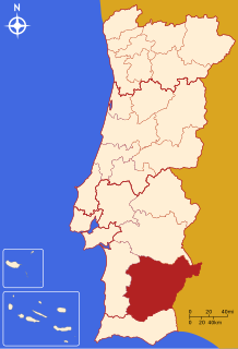
The Comunidade Intermunicipal do Baixo Alentejo is an administrative division in Portugal. It was created in 2009. It is also a NUTS3 subregion of the Alentejo Region. The seat of the intermunicipal community is Beja. Baixo Alentejo comprises 13 of the 14 municipalities of the Beja District. The population in 2011 was 126,692, in an area of 8,542.72 km².

Bordeira is a Portuguese civil parish in the municipality of Aljezur. The population in 2011 was 432, in an area of 79.87 km². It lies within the Southwest Alentejo and Vicentine Coast Natural Park, along the western coast of the Algarve in Faro District. The region, typical of the Algarve coastal areas, is dotted with many beaches, with the most important being the beaches of Praia do Amado and Praia da Carrapateira, which attract both local and tourist vacationers. It contains the village of Carrapateira.

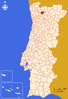
Aljezur is a town and municipality of the District of Faro and Algarve region, in Portugal. The population in 2011 was 5,884, in an area of 323.50 km². The municipality comprises 4 parishes.
Carrapateira is a village on the western coast of the Algarve, Portugal. Administratively, it is part of the civil parish of Bordeira, within the municipality of Aljezur, in the Faro District. Its landmarks include an old fort and a church. The nearby beaches are a popular surfing destination.

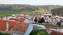
Praia de Odeceixe is a beach and small settlement within the Municipality of Aljezur, in the Algarve, Portugal. The beach is on the western seaboard in the extreme north west of the Algarve. It is in the Vicentine Coast Natural Park. The beach is 2.1 miles (3.4 km) west of the village of Odeceixe, and is 77.9 miles (125.4 km) north west, by road, from the region's capital of Faro. In 2012 Praia de Odeceixe was designated a blue Flag beach.

The Alentejo is a geographical, historical and cultural region of south central and southern Portugal. In Portuguese, its name means "beyond the Tagus river" (Tejo).
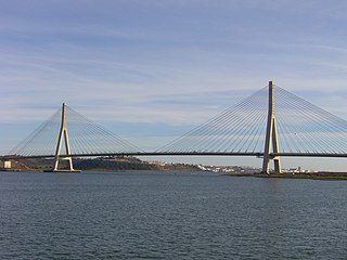
The Portugal–Spain border is referred to as "The Stripe". It is one of the oldest borders in the world. The current demarcation is almost identical to that defined in 1297 by the Treaty of Alcañices. The Portugal–Spain border is 1,214 km (754 mi) long, and is the longest uninterrupted border within the European Union. The border is not defined for 18 km (11 mi) between the Caia river and Ribeira de Cuncos, because of the disputed status of Olivenza/Olivença, which has been disputed between the two countries for two hundred years.

Almádena is a village located in Portugal's western Algarve. Administratively, it is part of the civil parish (freguesia) of Luz,, and the municipality (município) of Lagos.