Bischofswerda or Biskopicy is a small town in Germany at the western edge of Upper Lusatia in Saxony.

Böhlen is a town in Saxony, Germany, south of Leipzig. Its main features are a small airport and a power plant. It is located in the newly built Neuseenland, the lakes created in former open-pit mining areas.

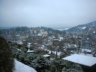
Herrnhut is an Upper Lusatian town in the Görlitz district in Saxony, Germany, known for the community of the Moravian Church established by Nicolas Ludwig, Count von Zinzendorf in 1722.

Mittweida is a town in Saxony, Germany, in the Mittelsachsen district.

Eibenstock is a town in the Erzgebirgskreis, Saxony, Germany. It is situated in the western Ore Mountains, near the river Mulde.

Borna is a town in Saxony, Germany, capital of the Leipzig district. It is situated approximately 30 km southeast of Leipzig city. It has approx. 19,000 inhabitants. The town is the district seat of the district of Leipzig.

Taucha is a town in the district of Nordsachsen, in Saxony, Germany. It is situated on the river Parthe, 10 km northeast of Leipzig.

Augustusburg is a town in the district of Mittelsachsen, in Saxony, Germany. It is situated 12 km east of Chemnitz. Augustusburg is known for its Jagdschloss, the hunting lodge of the same name.
Bad Elster is a spa town in the Vogtlandkreis district, in Saxony, Germany. It lies on the border of Bavaria and the Czech Republic in the Elster gebirge hills. It is situated on the river White Elster, and is protected from extremes of temperature by the surrounding wooded hills. It is 25 km southeast of Plauen, and 25 km northwest of Cheb. It is part of the Freunde im Herzen Europas microregion.

Bernstadt auf dem Eigen is a town in the Görlitz district, in Saxony, Germany. It is situated 16 km north of Zittau, and 16 km southwest of Görlitz.

Brand-Erbisdorf is a small town in the district of Mittelsachsen, in Saxony, Germany. It is situated 5 km south of Freiberg. As of 2020, the town has a population of 9,145.

Ehrenfriedersdorf is a town in the district of Erzgebirgskreis, in Saxony, Germany. It is situated 8 km northwest of Annaberg-Buchholz, and 21 km south of Chemnitz.

Falkenstein is a town in the Vogtlandkreis district, in Saxony, Germany. It is situated 4 km southwest of Auerbach, and 17 km east of Plauen.

Frauenstein is a town in the district of Mittelsachsen, in Saxony, Germany. It is situated in the eastern Ore Mountains, 19 km (11.81 mi) southeast of Freiberg, and 33 km (20.51 mi) southwest of Dresden.

Geringswalde is a town in the district of Mittelsachsen, in Saxony, Germany. It is situated 12 km northwest of Mittweida, and 27 km north of Chemnitz.
Gröditz is a town in the district Meißen, in Saxony, Germany. The town is located 12 km northeast of Riesa, and 7 km southwest of Elsterwerda.
Hartenstein is a town in the Zwickau district, in Saxony, Germany. It is situated on the river Zwickauer Mulde, 14 km southeast of Zwickau.
Klingenthal is a town in the Vogtland region, in Saxony, south-eastern Germany. It is situated directly on the border with the Czech Republic opposite the Czech town of Kraslice, 29 km southeast of Plauen, and 33 km northwest of Karlovy Vary.

Thum is a small town in the district of Erzgebirgskreis, in the Free State of Saxony, Germany. Thum has a population of about 5000.
Adolf Gottlieb Fiedler was a German entrepreneur in Saxony and Poland.