The cave
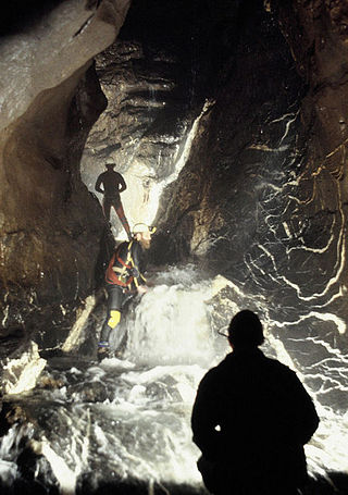
Ogof y Daren Cilau is one of the longest cave systems in the United Kingdom (over 26 kilometres/16 miles in total) and the entrance section is long, tight and strenuous, making the trip into the further parts of the cave a serious undertaking. [3] Its awkward 517-metre (1,696 ft) entrance crawl is a natural barrier to any casual visitor and precludes the need for a locked gate to protect it from vandals. Highlights of Daren Cilau include the "Time Machine", the largest cave passage in Britain; the "White Company", a set of pure white stalactites; and the "Bonsai Tree", a branching helictite. [3]
Because of the extent of the passages several kilometres from the entrance which would require trips of up to 20 hours to explore, some permanent underground camps have been established, including the "Restaurant at the End of the Universe", which is some thirteen hours from the entrance. [4]

Powys is a county and preserved county in Wales. It borders Gwynedd, Denbighshire, and Wrexham to the north; the English ceremonial counties of Shropshire and Herefordshire to the east; Monmouthshire, Blaenau Gwent, Merthyr Tydfil, Caerphilly, Rhondda Cynon Taf, and Neath Port Talbot to the south; and Carmarthenshire and Ceredigion to the west. The largest settlement is Newtown, and the administrative centre is Llandrindod Wells.

Brecknockshire, also known as the County of Brecknock, Breconshire, or the County of Brecon is one of thirteen historic counties of Wales, and a former administrative county. Named after its county town of Brecon, the county is mountainous and primarily rural.

Crickhowell is a town and community in southeastern Powys, Wales, near Abergavenny, and is in the historic county of Brecknockshire.

Ogof Craig a Ffynnon is a cave in Wales. The cave is about 7 km in length and is located at the base of a quarried rockface in the Clydach Gorge. Water flowing out of the cave is a resurgence of water draining off Llangatock Mountain above.
Ogof Ffynnon Ddu, also known informally as OFD, is a cave under a hillside in the area surrounding Penwyllt in the Upper Swansea Valley in South Wales. It is the second longest cave in Wales and the deepest in the United Kingdom.

The Black Mountains are a group of hills spread across parts of Powys and Monmouthshire in southeast Wales, and extending across the England–Wales border into Herefordshire. They are the easternmost of the four ranges of hills that comprise the Brecon Beacons National Park, and are frequently confused with the westernmost, which is known as the Black Mountain. The Black Mountains may be roughly defined as those hills contained within a triangle defined by the towns of Abergavenny in the southeast, Hay-on-Wye in the north and the village of Llangors in the west. Other gateway towns to the Black Mountains include Talgarth and Crickhowell. The range of hills is well known to walkers and ramblers for the ease of access and views from the many ridge trails, such as that on the Black Hill (Herefordshire) at the eastern edge of the massif. The range includes the highest public road in Wales at Gospel Pass, and the highest point in southern England at Black Mountain.

Fan Brycheiniog is the highest peak at a height of 802.5 metres (2,633 ft) in the Black Mountain region of the Brecon Beacons National Park in southern Wales. There is a trig point at the peak and on the edge of the escarpment, and nearby, a stone shelter with an inner seat. It lies just inside the historic county of Brecknockshire which gives the mountain its Welsh name. A subsidiary top, less than a kilometre from the summit along the ridge to the northwest, is the highest point of the neighboring county of Carmarthenshire. Fan Brycheiniog is also within the Fforest Fawr Geopark designated in 2005 in recognition of the area's geological heritage. The views of the moorland and open country to the north are spectacular when the weather is clear, and reveals the isolation of the range, especially when compared with the more popular Pen y Fan range to the east.
Ogof Agen Allwedd or Agen Allwedd, is, at 32.5 kilometres (20.2 mi), one of the longest cave systems in Wales, and the longest cave system on the Llangattock escarpment.

The Beacons Way is a waymarked long distance footpath in the Brecon Beacons National Park, Wales. It is a linear route which runs for 99 miles (159 km) east to west through the National Park, and passes many of the most important landmarks and mountain peaks in the mountain range. It also includes a few of the towns in the park as well as popular attractions such as Carreg Cennen Castle near Llandeilo at the western end of the path.

Craig y Cilau is a limestone escarpment in the Brecon Beacons National Park in Powys, Wales.

The River Giedd is a principal tributary of the River Tawe, Wales. The river runs within the county of Powys and lies almost wholly within the Brecon Beacons National Park.

Mynydd Llangatwg or Llangattock Mountain is a hill in the Brecon Beacons National Park in the county of Powys, south Wales. It is named from the village of Llangatwg which sits in the valley of the River Usk to the north of it. It is essentially an undulating plateau rising in the west to a height of 530 metres (1,740 ft) at grid reference SO171157 and in the east to a height of 529 metres (1,736 ft) at Hen Dy-aderyn / Twr Pen-cyrn. This spot is marked by a trig point. The shallow pool of Pwll Gwy-rhoc sits in a broad depression towards the northern edge of the plateau whilst a smaller pool frequently occupies a large shakehole a few hundred metres to its west. The hill forms an impressive northern scarp overlooking the Usk valley and commonly referred to as the Llangattock Escarpment. Its southern margins are more subdued. Its eastern end is defined by the drops into the Clydach Gorge. Beyond the B4560 to the west the hill merges with Mynydd Llangynidr which has a similar character.
Mynydd Llangynidr is a mountain in the Brecon Beacons National Park largely in the county of Powys, south Wales. Its southern slopes extend into the northernmost parts of the county borough of Blaenau Gwent. It is named from the village of Llangynidr which sits in the valley of the River Usk to the north of it. It is essentially an undulating plateau rising in the west to a height of 557m at Garn Fawr at OS grid ref SO 123151. A secondary high point is achieved at a point marked by a trig point at SO 147159. To the north the hill overlooks the valleys of Dyffryn Crawnon and Cwm Claisfer, themselves tributary valleys of the Usk. The shallow upper valley of the Ebbw River reaches into the plateau in the southeast whilst the upper reaches of the Sirhowy Valley and its tributary the Nant Trefil define its western margins. A further tributary, the Nant Milgatw, reaches in from the south whilst the sharp edge of Rassau Industrial Estate also defines a part of its southern margin. Passing east across the B4560, the hill merges with Mynydd Llangatwg which has a similar character.

Llangattock is a village, community and electoral ward in the Brecon Beacons National Park in Powys, Wales. It lies in the Usk Valley just across the river from the town of Crickhowell. The Monmouthshire and Brecon Canal passes through the village en route between Brecon and Pontypool. It is in the historic county of Breconshire.
Esclusham Mountain is an area in Wrexham County Borough, Wales, United Kingdom, and is part of the Ruabon Moors. It rises to a height of 460 m, with the nearby spur of Cyrn-y-Brain, to the west, reaching 473 m. It lies mostly within the community of Esclusham. A smaller spur to the north, known as Minera Mountain, is within the neighbouring community of Minera.
Martyn Farr is a leading exploratory cave diver and caver, known for his record-breaking cave dives and the exploration of many miles of previously undiscovered underground passages. As an author and photographer he has written many books on the subject of cave diving history and techniques and caving locations.
Chartist Cave is a culturally significant cave on Mynydd Llangynidr in southern Powys, Wales. The entrance is a broad arch formed of Twrch Sandstone which overlies the Carboniferous Limestone immediately beneath.
This article describes the geology of the Brecon Beacons National Park in mid/south Wales. The area gained national park status in 1957 with the designated area of 1,344 km2 (519 sq mi) including mountain massifs to both the east and west of the Brecon Beacons proper. The geology of the national park consists of a thick succession of sedimentary rocks laid down from the late Ordovician through the Silurian and Devonian to the late Carboniferous period. The rock sequence most closely associated with the park is the Old Red Sandstone from which most of its mountains are formed. The older parts of the succession, in the northwest, were folded and faulted during the Caledonian orogeny. Further faulting and folding, particularly in the south of the park is associated with the Variscan orogeny.
