Ohio State Route 644

Last updated

OH-644.svg

State Route 644
OH 644 map.svg
Route information
Maintained by ODOT
Length 11.60 mi [1] (18.67 km)
Existed 1937 – present
Major junctions
South endOH-39.svg SR 39 in Salineville
North endUS 30.svgOH-9.svg US 30 / SR 9 in Kensington
Location
Counties Columbiana, Carroll
Highway system
OH-643.svg SR 643 SR 646 OH-646.svg

State Route 644 (SR 644) is a northsouth state highway running through Columbiana and Carroll counties in northeast Ohio. Its southern terminus is at SR 39 in downtown Salineville, and its northern terminus is at its junction with U.S. Route 30(US 30) and SR 9 in the center of Kensington. The route connects mainly rural and a few unincorporated parts of southeastern Columbiana County. SR 644 only briefly passes into a corner of Carroll County for a 0.41-mile (0.66 km) journey.

A state highway, state road, or state route is usually a road that is either numbered or maintained by a sub-national state or province. A road numbered by a state or province falls below numbered national highways in the hierarchy. Roads maintained by a state or province include both nationally numbered highways and un-numbered state highways. Depending on the state, "state highway" may be used for one meaning and "state road" or "state route" for the other.

Columbiana County, Ohio County in the United States

Columbiana County is a county located in the U.S. state of Ohio. As of the 2010 census, the population was 107,841. The county seat is Lisbon. The county name is derived from the explorer of the Americas, Christopher Columbus.

Carroll County, Ohio County in the United States

Carroll County is a county located in the state of Ohio. As of the 2010 census, the population was 28,836. Its county seat is Carrollton. It is named for Charles Carroll of Carrollton, the last surviving signer of the Declaration of Independence.

Contents

Route description

The starting point of SR 644 is its junction with SR 39 in the Columbiana County village of Salineville, at the intersection of Main Street and Lincoln Street. SR 644 follows Main Street west from this intersection, and turns northerly after two blocks, as the road becomes known as Hanover Road. The route bends northwesterly, then passes by Woodlawn Cemetery, turns northerly again, and back to the northwest, as it heads out of the village limits of Salineville through a wooded setting. Entering into Washington Township, SR 644 intersects Walnut Ridge Road, turns west-northwesterly, then curves north-northwesterly, as it ducks just barely into Carroll County, and correspondingly, Fox Township. SR 644 has no intersections in the 0.41-mile (0.66 km) it covers in Carroll County, [1] just passing by a blend of woods and fields. SR 644 re-enters Columbiana County, this time into Franklin Township. Trending northwesterly, SR 644 meets Dobson Road, then curves to the west-northwest. The rural setting the highway traverses is a blend of woods and fields, with a few homes dotting the landscape. SR 644 bends northwesterly, then follows a reverse curve northerly before resuming a northwesterly path. Next, it passes by intersections with Hull Road and Lewis Road, where the highway turns to the north. Further along, SR 644 bends to the northeast, then starts to curve to the northwest as it enters into Summitville. Once within the village, SR 644 follows Main Street, and has an intersection with Yellow Creek Church Road. The route turns north into the main portion of the village, then turns northeasterly to pass underneath the Norfolk Southern Railway. [1] Resuming a northerly course, SR 644 passes by intersections with Fink Road and Summitville Road before departing Summitville, and re-entering Franklin Township. The route bends northeastly, then north again, as it passes by the hamlet of Millport, where it meets SR 518 at its western terminus. [2]

Washington Township, Columbiana County, Ohio Township in Ohio, United States

Washington Township is one of the eighteen townships of Columbiana County, Ohio, United States. The 2010 census reported 2,264 people living in the township, 953 of whom were in the unincorporated portions of the township.

Fox Township, Carroll County, Ohio Township in Ohio, United States

Fox Township is one of the fourteen townships of Carroll County, Ohio, United States. As of the 2010 census, the population was 1,041.

Franklin Township, Columbiana County, Ohio Township in Ohio, United States

Franklin Township is one of the eighteen townships of Columbiana County, Ohio, United States. The 2010 census reported 835 people living in the township, 700 of whom lived in the unincorporated portions of the township.

Continuing north of SR 518, SR 644 curves to the northwest, passes by a split intersection with Willard Road, then meets Bethesda Road. Next, the route bends to the west briefly, then resumes a northwesterly trek, and comes upon a split intersection with McKaig Road. SR 644 then passes just to the east of the northeasternmost point in Carroll County, while remaining in Columbiana County, crossing from Franklin Township into Hanover Township. SR 644 bends north, turns northwesterly, then begins to trend to the west as it approaches Mechanicstown Road. Beyond there, SR 644 turns to the west-northwest, closely paralleling the Norfolk Southern railway that exists to the south of the highway, as SR 644 enters the unincorporated community of Kensington. Passing by a number of homes, SR 644 comes to an end as it arrives at its junction with US 30 and SR 9. [2]

Hanover Township, Columbiana County, Ohio Township in Ohio, United States

Hanover Township is one of the eighteen townships of Columbiana County, Ohio, United States. The 2010 census reported 3,704 people living in the township, 3,296 of whom were in the unincorporated portions of the township.

History

In 1937, SR 644 was designated along the route that it currently occupies, and has not experienced any major changes in its routing since its inception. [3] [4]

Major intersections

CountyLocationmi [1] kmDestinationsNotes
Columbiana Salineville 0.000.00OH-39.svg SR 39 (West Main Street / Lincoln Street) Wellsville, Carrollton
Carroll
No major junctions
Columbiana Franklin Township 6.6910.77OH-518.svg SR 518 east West Point Western terminus of SR 518
Hanover Township 11.6018.67US 30.svgOH-9.svg US 30 (Lincoln Highway) / SR 9  Salem, Minerva, Carrollton
1.000 mi = 1.609 km; 1.000 km = 0.621 mi

Related Research Articles

Ohio State Route 385 highway in Ohio

State Route 385 is an east–west state highway in the western portion of Ohio. The western terminus of State Route 385 is at U.S. Route 33 in New Hampshire, at a signalized intersection that doubles as the southern terminus of State Route 196. State Route 385's eastern terminus is at State Route 117 in the unincorporated community of Roundhead, less than two blocks northwest of State Route 117's junction with State Route 235.

Ohio State Route 43 highway in Ohio

State Route 43 is a mainly north–south state highway that runs through the northeastern quadrant of the U.S. state of Ohio. Its southern terminus is at a signalized intersection with State Route 7 along the Ohio River in Steubenville, and its western terminus is approximately 123 miles (198 km) to the north at Public Square in Cleveland. It is one of ten routes to enter Public Square.

Ohio State Route 638 highway in Ohio

State Route 638 is a two-lane north–south state highway in the west central portion of Ohio, a U.S. state. SR 638 has its southern terminus at an intersection with U.S. Route 68 (US 68) just over six miles (9.7 km) north of the city of Bellefontaine. The northern terminus of the route is at SR 273 at the extreme southeastern corner of the village of Belle Center.

Pennsylvania Route 74 highway in Pennsylvania

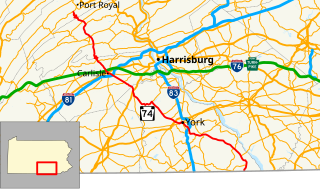
Pennsylvania Route 74 is a 96.4-mile-long (155.1 km) north–south state highway located in central Pennsylvania. The southern terminus of the route is at the Mason–Dixon line southwest of Delta, where PA 74 continues into Maryland as Maryland Route 165. The northern terminus is at Pennsylvania Route 75 south of Port Royal.

Ohio State Route 553 highway in Ohio

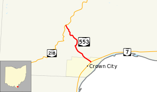
State Route 553 is a north–south state highway in the southern portion of the U.S. state of Ohio. SR 553 has its southern terminus at a T-intersection with SR 7 in Crown City. The route's northern terminus is at SR 218 approximately two miles (3.2 km) northwest of Crown City.

Ohio State Route 373 highway in Ohio

State Route 373 is north–south state highway in the southern portion of Ohio. Its southern terminus is just over eleven miles (18 km) north of Ironton at SR 93 at the hamlet of Bartles, and its northern terminus is at about three miles (4.8 km) to the north of its southern terminus, also at SR 93.

Ohio State Route 515 highway in Ohio

State Route 515 is a north-south state highway located in east-central Ohio. Existing entirely within the northeastern portion of Holmes County in Ohio's Amish Country, SR 515 has its southern terminus at a signalized intersection with SR 39 in the unincorporated community of Walnut Creek. Its northern terminus is at a T-intersection with U.S. Route 62 (US 62) one mile (1.6 km) southwest of the hamlet of Winesburg.

Ohio State Route 566 highway in Ohio

State Route 566 is a north–south state highway in eastern Ohio, a U.S. state. Located exclusively in northern Noble County, SR 566 has its southern terminus at SR 147, at a T-intersection 1.25 miles (2.01 km) north of the unincorporated community of Mount Ephraim. Its northern terminus is at another T-intersection, this time with SR 285 approximately 1.25 miles (2.01 km) south of the village of Senecaville.

Ohio State Route 546 highway in Ohio

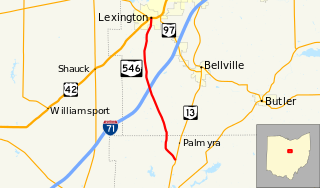
State Route 546 is a north–south state highway in the northern portion of the U.S. state of Ohio. The southern terminus of SR 546 is at a T-intersection with SR 13 nearly two and a half miles (4.0 km) north of Fredericktown. Its northern terminus is at a signalized intersection with the U.S. Route 42 (US 42)/SR 97 concurrency in Lexington.

Ohio State Route 518 highway in Ohio

State Route 518 is an east–west state highway located entirely in Columbiana County in northeast Ohio. The western terminus of SR 518 is at SR 644 north of Summitville. Its eastern terminus is at the concurrency of U.S. Route 30 (US 30) and SR 45 near West Point.

Ohio State Route 626 highway in Ohio

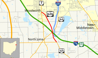
State Route 626 is a north–south state highway in the northeastern portion of the U.S. state of Ohio. The southern terminus of SR 626 is at SR 165 approximately one and a half miles (2.4 km) southeast of the hamlet of North Lima. Its northern terminus is at SR 7 nearly two miles (3.2 km) south of the township of Boardman.

Ohio State Route 691 highway in Ohio

Ohio State Route 691 is a north–south state route in southern Ohio. The entirety of SR 691 is within Athens County. Its southern terminus is at OH 56 about 1.5 miles (2.4 km) northwest of New Marshfield, and its northern terminus is at an interchange with US 33 and SR 78 in Nelsonville.

Ohio State Route 282 highway in Ohio

State Route 282 is a north–south state highway in northeastern Ohio, a U.S. state. The southern terminus of SR 282 is at a T-intersection with SR 305 near the hamlet of Nelson. Its northern terminus is also at a T-intersection, this time with the four-lane divided U.S. Route 422 (US 422) approximately two miles (3.2 km) southeast of Parkman. SR 282 primarily serves as an access route for Nelson Kennedy Ledges State Park. For its duration, the highway is also known as Nelson Ledge Road.

Ohio State Route 748 highway in Ohio

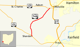
State Route 748 is a north–south state highway in southwestern Ohio, a U.S. state. Situated in west-central Butler County, SR 748 has its southern terminus at SR 126 in the unincorporated community of Shandon. Its northern terminus is at SR 129 near Millville, just one-half mile (0.80 km) west of SR 129's junction with U.S. Route 27.

Ohio State Route 187 highway in Ohio

State Route 187 (SR 187) is a 8.22-mile (13.23 km) north–south state highway in the central portion of the U.S. state of Ohio. The southern terminus of SR 187 is at a T-intersection with SR 56 approximately 4.25 miles (6.84 km) northwest of London. Its northern terminus is at a T-intersection with SR 29 about one mile (1.6 km) to the southeast of Mechanicsburg.

Ohio State Route 555 highway in Ohio

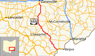
State Route 555 is a 62.36-mile-long (100.36 km), north–south running state highway that passes through four counties in southeastern Ohio. State Route 555's southern terminus is at the concurrency of US 50, SR 7 and SR 32 in the unincorporated community of Little Hocking in extreme southwestern Washington County. Its northern terminus is at SR 60 in Wayne Township, just outside Zanesville. The route passes through primarily rural portions of Washington, Morgan, Perry, and Muskingum counties, connecting unincorporated villages along the way. Its emergence into southern Zanesville at the route's northern end takes the route into a more suburban setting before it terminates.

Ohio State Route 216 highway in Ohio

State Route 216 is a north–south state highway in the southeastern quadrant of the U.S. state of Ohio. The southern terminus of SR 216 is at a three-way stop T-intersection with SR 78 in Murray City. SR 216's northern terminus is also at a three-way stop T-intersection, this time with SR 93 in New Straitsville.

Ohio State Route 606 highway in Ohio

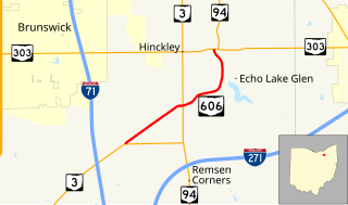
State Route 606 is a north–south state highway in the northeastern quadrant of the U.S. state of Ohio. The southern terminus of SR 606 is at a T-intersection with SR 3 approximately 4.50 miles (7.24 km) northeast of Medina. The highway's northern terminus is at another T-intersection, this time with the SR 94/SR 303 concurrency nearly 3.25 miles (5.23 km) west of Richfield.

Ohio State Route 312 highway in Ohio

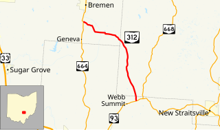
State Route 312 (SR 312) is a north–south state highway located in the southern portion of the U.S. state of Ohio. SR 312 runs from its southern terminus at a T-intersection with SR 93 approximately 4.25 miles (6.84 km) northeast of Logan to its northern terminus at a T-intersection with SR 664 nearly 1.25 miles (2.01 km) south of Bremen.

State Route 55 is an east-west highway in Middle Tennessee. The road begins at SR 50 in Lynchburg and ends at U.S. Route 70S and SR 380 in McMinnville. The current length is 53.40 mi (85.9 km). SR 55 heads northeast from Lynchburg to Tullahoma as a two-lane road. In Tullahoma, the route runs concurrent with US 41A. From here, SR 55 heads northeast as a multilane highway to Manchester, where it intersects US 41 and Interstate 24 (I-24). The route continues northeast, serving Summitville and Morrison before it reaches McMinnville.

References

Route map: Google

KML file (edithelp)
KML is from Wikidata
  1. 1 2 3 4 "DESTAPE". Ohio Department of Transportation. June 24, 2015. Retrieved November 5, 2015.
  2. 1 2 Google (November 5, 2015). "Ohio State Route 644" (Map). Google Maps . Google. Retrieved November 5, 2015.
  3. Ohio State Map (Map). Ohio Department of Transportation. 1936.
  4. Ohio State Map (Map). Ohio Department of Transportation. 1937.