Related Research Articles

Windhoek is the capital and largest city of Namibia. It is located in central Namibia in the Khomas Highland plateau area, at around 1,700 m (5,600 ft) above sea level, almost exactly at the country's geographical centre. The population of Windhoek, which was 431,000 in 2020, is constantly growing due to a continued migration from other regions in Namibia.

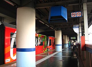
Tsuen Wan is the northern terminus of the MTR Tsuen Wan line in Hong Kong. It is the only station on the Tsuen Wan line at ground level. It is located in the northern central part of Tsuen Wan New Town, New Territories West. The preceding station is Tai Wo Hau.
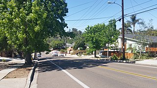
The College Area is a residential community in the Mid-City region of San Diego, California, United States. The College Area is dominated by San Diego State University, after which the area is named. Several neighborhoods in the College Area were developed in the 1930s, with others becoming established in the post-war period. The College Area is bordered on the west by Kensington and Talmadge and on the east by the city of La Mesa. El Cajon Boulevard is a busy shopping district; additional retail, entertainment and dining establishments are located in a new housing and commercial complex known as South Campus Plaza on College Avenue at Aztec Center. The College Area includes the neighborhoods of the Catoctin Area, Dennstedt Point, East Falls View Drive, Saranac-Mohawk, and an Orthodox Jewish neighborhood in the area near Congregation Beth Jacob Orthodox Synagogue on College Avenue. The region includes Alvarado Hospital, a 306-bed acute care facility, and the College-Rolando branch of the San Diego Public Library.

The Harbor Transitway is a 10.3-mile (16.6 km) shared-use express bus corridor and high occupancy toll (HOT) lanes running in the median of Interstate 110 between Downtown Los Angeles and the Harbor Gateway Transit Center in Gardena, California. Buses also make intermediate stops at 37th Street/USC, Slauson, Manchester, Harbor Freeway, and Rosecrans stations. The facility opened for two-person carpools on June 26, 1996, for buses on August 1, 1996 and was converted to HOT lanes as part of the Metro ExpressLanes project on November 10, 2012.

3rd Street in Los Angeles is a major east–west thoroughfare. The west end is in downtown Beverly Hills by Santa Monica Boulevard, and the east is at Alameda Street in downtown Los Angeles, where it shares a one-way couplet with 4th Street. East of Alameda it becomes 4th Street, where it heads to East Los Angeles, where it turns back into 3rd Street upon crossing Indiana Street. 3rd Street eventually becomes Pomona Boulevard in Monterey Park, where it then turns into Potrero Grande Drive and finally turns into Rush Street in Rosemead and ends in El Monte.

The El Monte Busway is a 12-mile (19 km) shared-use express bus corridor (busway) and high occupancy toll (HOT) lanes running along Interstate 10 between Union Station in Downtown Los Angeles and Interstate 605 or El Monte Station in El Monte, California. Buses also make intermediate stops at Cal State LA station and Los Angeles General Medical Center station. The busway opened in January 1973 to buses only, three-person carpools were allowed to enter in 1976, and the facility was converted to HOT lanes as part of the Metro ExpressLanes project on February 22, 2013.
North Avenue station is an elevated Metro Rail Transit (MRT) station located on the MRT Line 3 (MRT-3) system in Diliman, Quezon City. It is named after its location, which is at the corner of Epifanio de los Santos Avenue (EDSA) and North Avenue, it is the current northern terminus of the line.

Ayala station, also known as Ayala Center station, is an underground Metro Rail Transit (MRT) station located on the MRT Line 3 (MRT-3) system in Makati. It is one of two underground stations that can be found on the line, the other being Buendia. The station is located in Makati and is named so due to its proximity to two places bearing the Ayala name: Ayala Center and Ayala Avenue.

Hiroshima Station is a major railway station in Minami-ku, Hiroshima, Japan, operated by West Japan Railway Company. Hiroshima Station is the terminal station for several lines, and all San'yō Shinkansen trains stop here.

Los Angeles General Medical Center station is a busway station located in the Boyle Heights neighborhood of Los Angeles, California. It is situated between Union Station and Cal State LA station on the El Monte Busway. The station is served by two bus rapid transit routes: the J Line, operated by Metro and the Silver Streak, operated by Foothill Transit. It is also used by several Metro Express and Foothill Transit bus services, most of which only run during weekday peak periods. The station consists of an island platforms in the center of the El Monte Busway, near its namesake, the Los Angeles General Medical Center. The station was completed on November 4, 1974, and is accessed by a bridge from Pomeroy Avenue between Kingston Avenue and Brittania Street.
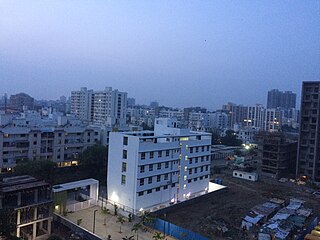
Hadapsar is a developed town in eastern Pune City, Maharashtra, India. After 1990, Hadapsar developed into a major industrial area and is now one of the most densely populated and developed areas of Pune District. It is well connected to all parts of city. Distances to popular city centers is: Pune Railway Station 8 km, Lohegaon Airport 8 km, Koregaon Park 5 km, Swargate Bus Stand 7 km and Shivaji Nagar Railway Station 12 km.

Palo Alto station is an intermodal transit center in Palo Alto, California. It is served by Caltrain regional rail service, SamTrans and Santa Clara VTA local bus service, Dumbarton Express regional bus service, the Stanford University Marguerite Shuttle, and several local shuttle services. Palo Alto is the second-busiest Caltrain station after San Francisco, averaging 7,764 weekday boardings by a 2018 count. The Caltrain station has two side platforms serving the two tracks of the Peninsula Subdivision and a nearby bus transfer plaza.

Magallanes station is an elevated Metro Rail Transit (MRT) station located on the MRT Line 3 (MRT-3) system in Makati. The station is named after barangay Magallanes of Makati, which in turn is named after Ferdinand Magellan, who discovered the Philippines for Spain on April 15, 1521. Although the station is named after Magallanes, it also serves passengers from Kayamanan-C and barangays Dasmariñas, Pio del Pilar, and San Lorenzo in Makati, and those from Taguig.

Hercules Transit Center is a major commuter hub in the western Contra Costa County city of Hercules, California. It is anchored by WestCAT bus services. The center was originally on San Pablo Avenue. In August 2009, the transit center was relocated to the other side of I-80 with additional paid parking, which is $3/day.

Méier is a middle class and upper middle class neighborhood in the North Zone of Rio de Janeiro, Brazil. The neighborhood is the historic center of the "Área dos Engenhos", or "Mill Area", which today is known as Grande Méier and has been a sub-prefecture since 2013. As a result, it has a wide range of shops and a variety of services and transport, although it is not one of the largest neighborhoods of the municipality. In the neighborhood is located one of the first shopping centers in Brazil, Shopping do Méier, opened in 1963. It has two distinct urban appearances, one more bustling, commercial, in the areas close to the train station, and a quieter one, on more residential streets.

El Monte station is a train station on Metrolink's San Bernardino Line in El Monte, California. It is at 10925 Railroad Street between Santa Anita and Tyler Avenues north of Valley Boulevard. It has 238 parking spaces. The station is owned by the City of El Monte.

The J Line is a 38-mile (61.2 km) bus rapid transit line that runs between El Monte, Downtown Los Angeles and the Harbor Gateway, with some trips continuing to San Pedro. It is one of the two lines in the Metro Busway system operated by the Los Angeles County Metropolitan Transportation Authority (Metro).

Gilmore Avenue, formerly known as Gilmore Street, is a two-lane, one-way road in Quezon City, Metro Manila, the Philippines. It runs one-way from Eulogio Rodriguez Sr. Avenue in New Manila and terminates at Nicanor Domingo Street in Valencia, continuing on as the two-way Granada Street until it reaches the city border with San Juan, where it becomes Ortigas Avenue.
The Metro ExpressLanes project is a transport project in Los Angeles County, California that debuted in 2012 to "improve traffic flow and provide enhanced travel options on I-10 and I-110 in Los Angeles County". It includes a range of infrastructure developments on the Harbor Transitway and the El Monte Busway. The existing high-occupancy lanes on these transitways were converted to high-occupancy toll lanes. Associated works included a major upgrade to the El Monte bus station, expansion of Metrolink's Pomona–North station, the creation of a new transit station at Union Station, and increased park and ride capacity and bike lockers at many transit stations. In addition, new vanpool vehicles and buses will be purchased. The project was delivered by the Los Angeles County Metropolitan Transportation Authority, the California Department of Transportation, and others. The budget was $290 million and construction, which began in 2011, was completed in February 2013. Some transit improvements for the Metro J Line are still being worked on.

Nob Hill is a neighborhood in Albuquerque, New Mexico, United States, consisting of a commercial district along Central Avenue and surrounding residential areas. Located just east of the University of New Mexico, the neighborhood was developed between about 1925 and 1950 and has since become a popular tourist and shopping destination. Known for its eclectic mix of mostly locally owned businesses, Nob Hill has been described as "the heart of Albuquerque's Route 66 culture and also its hippest, funkiest retail and entertainment district". The neighborhood is named after Nob Hill in San Francisco, California.
References
Constituencies in the Khomas Region of Namibia | ||
|---|---|---|
| ||
| | This Namibia location article is a stub. You can help Wikipedia by expanding it. |