
The National Road was the first major improved highway in the United States built by the federal government. Built between 1811 and 1837, the 620-mile (1,000 km) road connected the Potomac and Ohio Rivers and was a main transport path to the West for thousands of settlers. When improved in the 1830s, it became the second U.S. road surfaced with the macadam process pioneered by Scotsman John Loudon McAdam.

Allegheny County is located in the southwest of the U.S. state of Pennsylvania. As of the 2020 census, the population was 1,250,578, making it the state's second-most populous county, following Philadelphia County. The county seat is Pittsburgh. Allegheny County is included in the Pittsburgh, PA Metropolitan Statistical Area, and in the Pittsburgh Designated Market Area.

Westmoreland County is a county located in the U.S. state of Pennsylvania. At the 2010 census, the population was 365,169. The county seat is Greensburg. Formed from, successively, Lancaster, Northumberland, and later Bedford counties, Westmoreland County was founded on February 26, 1773, and was the first county in the colony of Pennsylvania whose entire territorial boundary was located west of the Allegheny Mountains. Westmoreland County originally included the present-day counties of Fayette, Washington, Greene, and parts of Beaver, Allegheny, Indiana, and Armstrong counties. It is named after Westmorland, a historic county of England.

The Allegheny Portage Railroad was the first railroad constructed through the Allegheny Mountains in central Pennsylvania, United States; it operated from 1834 to 1854 as the first transportation infrastructure through the gaps of the Allegheny that connected the midwest to the eastern seaboard across the barrier range of the Allegheny Front. Approximately 36 miles (58 km) long overall, both ends connected to the Pennsylvania Canal, and the system was primarily used as a portage railway, hauling river boats and barges over the divide between the Ohio and the Susquehanna Rivers. Today, the remains of the railroad are preserved within the Allegheny Portage Railroad National Historic Site operated by the National Park Service.

Allegheny City was a municipality that existed in the U.S. state of Pennsylvania from 1788 until it was annexed by Pittsburgh in 1907. It was located north across the Allegheny River from downtown Pittsburgh, with its southwest border formed by the Ohio River, and is known today as the North Side. The city's waterfront district, along the Allegheny and Ohio rivers, became Pittsburgh's North Shore neighborhood.

Allegheny West is a historic neighborhood in Pittsburgh, Pennsylvania's North Side. It has two zip codes of both 15233 and 15212, and has representation on Pittsburgh City Council by the council member for District 1.

California-Kirkbride is a neighborhood on Pittsburgh, Pennsylvania's North Side.
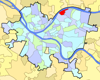
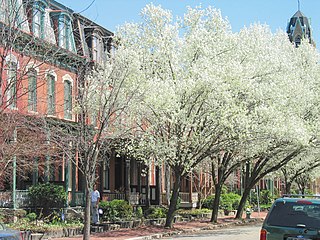
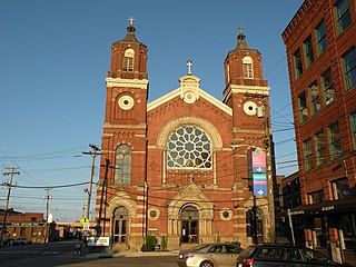
Lawrenceville is one of the largest neighborhood areas in Pittsburgh in the U.S. state of Pennsylvania. It is located northeast of downtown, and like many of the city's riverfront neighborhoods, it has an industrial past. The city considers Lawrenceville three neighborhoods, Upper Lawrenceville, Central Lawrenceville, and Lower Lawrenceville, but these distinctions have little practical effect. Accordingly, Lawrenceville is almost universally treated as being a single large neighborhood.
Manchester is a neighborhood on Pittsburgh, Pennsylvania's North Side. It has a ZIP code of 15233, and has representation on Pittsburgh City Council by the council member for District 6. Manchester houses PBF Battalion 1 & 37 Engine, and is covered by PBP Zone 1 and the Bureau of EMS Medic 4. The neighborhood includes the Manchester Historic District, which protects, to some degree, 609 buildings over a 51.6-acre (20.9 ha) area. The district was listed on the National Register of Historic Places in 1975.

This is a list of properties and districts listed on the National Register of Historic Places in Pennsylvania. As of 2015, there are over 3,000 listed sites in Pennsylvania. Sixty-six of the 67 counties in Pennsylvania have listings on the National Register; Cameron County is the only county without any sites listed.

The Allegheny County Courthouse in downtown Pittsburgh, Pennsylvania, is part of a complex designed by H. H. Richardson. The buildings are considered among the finest examples of the Romanesque Revival style for which Richardson is well known.

This is a list of the National Register of Historic Places listings in Allegheny County, Pennsylvania.

The Mexican War Streets, originally known as the "Buena Vista Tract", is a historic district in the Central Northside neighborhood of Pittsburgh, Pennsylvania, in the United States. The district is densely filled with restored row houses, community gardens, and tree-lined streets and alleyways. The area dates to around the time of the Mexican–American War.
The Pittsburgh History & Landmarks Foundation (PHLF) is a nonprofit organization founded in 1964 to support the preservation of historic buildings and neighborhoods in Pittsburgh, Pennsylvania, USA.

The following properties are listed on the National Register of Historic Places in Pittsburgh, Pennsylvania.

The O'Hara Student Center, formerly the Concordia Club, is a three-story, 18,000-square-foot (1,700 m2) building on the campus of the University of Pittsburgh on O'Hara Street in the Oakland neighborhood of Pittsburgh, Pennsylvania. It is a contributing property to the Schenley Farms National Historic District and the City of Pittsburgh Oakland Civic Center Historic District. The building was acquired by the university in mid-December, 2009. and has since been renovated to house academic and student activity programs.
Frederick C. Sauer was a German-American architect, particularly in the Pittsburgh, Pennsylvania, region of the late 19th and early 20th centuries.

Hamnett Historic District is a historic district in Wilkinsburg, Pennsylvania. Bordered roughly by Rebecca Avenue, the rear property lines on the east side of Center Street, Sewer Way, and Lytle Way, it encompasses 77 buildings and 114 acres.

C.W. Bill Young Lock and Dam in Harmar Township, Allegheny County, Pennsylvania, and Plum, Pennsylvania, is a lock that was built in 1932. The lock and fixed-crest dam were built by the U.S. Army Corps of Engineers as a part of an extensive system of locks and dams to improve navigation along the Allegheny River.
David F. Creighton was an architect, mechanical engineer, and construction manager from Pennsylvania. He designed worker housing in Gary, Indiana that incorporated concrete and terraces in what was termed terraced housing "based on the Philadelphia plan". It was progressive and "homey" and imaginative in its details. About 77 of the houses that he designed in Gary survive.

