
The Mississippi River is the primary river of the largest drainage basin in the United States. From its traditional source of Lake Itasca in northern Minnesota, it flows generally south for 2,340 miles (3,766 km) to the Mississippi River Delta in the Gulf of Mexico. With its many tributaries, the Mississippi's watershed drains all or parts of 32 U.S. states and two Canadian provinces between the Rocky and Appalachian mountains. The river either borders or passes through the states of Minnesota, Wisconsin, Iowa, Illinois, Missouri, Kentucky, Tennessee, Arkansas, Mississippi, and Louisiana. The main stem is entirely within the United States; the total drainage basin is 1,151,000 sq mi (2,980,000 km2), of which only about one percent is in Canada. The Mississippi ranks as the world's tenth-largest river by discharge flow, and the largest in North America.

Alton is a city on the Mississippi River in Madison County, Illinois, United States, about 18 miles (29 km) north of St. Louis, Missouri. The population was 25,676 at the 2020 census. It is a part of the River Bend area in the Metro-East region of the Greater St. Louis metropolitan area.

Bethalto is a village in Madison County, Illinois, United States. Bethalto, like the rest of Madison County, is part of the Illinois Metro East portion of the Greater St. Louis metropolitan area.

U.S. Route 67 is a major north–south U.S. highway which extends for 1,560 miles (2,511 km) in the Central United States. The southern terminus of the route is at the United States-Mexico border in Presidio, Texas, where it continues south as Mexican Federal Highway 16 upon crossing the Rio Grande. The northern terminus is at U.S. Route 52 in Sabula, Iowa. US 67 crosses the Mississippi River twice along its routing. The first crossing is at West Alton, Missouri, where US 67 uses the Clark Bridge to reach Alton, Illinois. About 240 miles (390 km) to the north, US 67 crosses the river again at the Rock Island Centennial Bridge between Rock Island, Illinois, and Davenport, Iowa. Additionally, the route crosses the Missouri River via the Lewis Bridge a few miles southwest of the Clark Bridge.

The Stan Musial Veterans Memorial Bridge is a bridge across the Mississippi River in the United States between St. Clair County, Illinois, and the city of St. Louis, Missouri. Built between April 19, 2010, and July 2013, the bridge opened on February 9, 2014. The cable-stayed bridge has a main span of 1,500 feet (460 m).

The old Chain of Rocks Bridge spans the Mississippi River on the north edge of St. Louis, Missouri, United States. The eastern end of the bridge is on Chouteau Island, while the western end is on the Missouri shoreline. Its most notable feature is a 22-degree bend occurring at the middle of the crossing, which was found to be necessary during construction due to both the presence of a water intake and the inability of parts of the bedrock of the river to carry the weight of the bridge.
Illinois Route 3 (IL 3) is a 187.44-mile-long (301.66 km) major north–south arterial state highway in southwestern Illinois. It has its southern terminus at Cairo Junction at the intersection of U.S. Route 51 (US 51) and Illinois Route 37, and its northern terminus in Grafton at IL 100.
The Metro East is an urban area in Southern Illinois, United States that contains the eastern and northern urban, suburban, and exurban areas on the Mississippi River in Greater St Louis. It encompasses eight Illinois counties and constitutes the second-most populous metropolitan area in Illinois.

The Congressman William L. Clay Sr. Bridge, formerly known as the Bernard F. Dickmann Bridge and popularly as the Poplar Street Bridge or PSB, completed in 1967, is a 647-foot-long (197 m) deck girder bridge across the Mississippi River between St. Louis, Missouri, and East St. Louis, Illinois. The bridge arrives on the Missouri shore line just south of the Gateway Arch.

The Clark Bridge is a cable-stayed bridge across the Mississippi River between West Alton, Missouri and Alton, Illinois. Named after explorer William Clark like the bridge it replaced, the cable-stayed bridge opened in 1994. It carries U.S. Route 67 across the river. It is the northernmost river crossing in the St. Louis metropolitan area.

The New Chain of Rocks Bridge is a pair of bridges across the Mississippi River on the north edge of St. Louis, Missouri. It was constructed in 1966 to bypass the Chain of Rocks Bridge immediately to the south. It originally carried traffic for Bypass US 66 and currently carries traffic for Interstate 270. The bridge opened to traffic on September 2, 1966.

Transportation in Greater St. Louis, Missouri includes road, rail, ship, and air transportation modes connecting the bi-state St. Louis metropolitan area with surrounding communities throughout the Midwest, national transportation networks, and international locations. The Greater St. Louis region also supports a multi-modal transportation network that includes bus, paratransit, and light rail service in addition to shared-use paths, bike lanes and greenways.

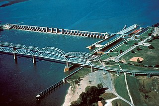
Melvin Price Locks and Dam is a dam and two locks at river mile 200.78 on the Upper Mississippi River, about 17 miles (27 km) north of Saint Louis, Missouri. The collocated National Great Rivers Museum, explains the structure and its engineering.
The Manufacturers Railway Company is a defunct railway company in St. Louis, Missouri. It was owned by Anheuser-Busch.

Lock and Dam No. 19 is a lock and dam located on the Upper Mississippi River near Keokuk, Iowa. In 1978, the Keokuk Lock and Dam was listed in the National Register of Historic Places, #78001234. In 2004, the facility was listed in the National Register of Historic Places as Lock and Dam No. 19 Historic District, #04000179 covering 1,605 acres (650 ha), 7 buildings, 12 structures, 1 object. The lock is owned and operated by the U.S. Army Corps of Engineers. The dam is owned and operated by Ameren Missouri.
Lock and Dam No. 26 was a lock and dam located near Alton, Illinois on the Upper Mississippi River around river mile 202.5.
U.S. Route 67 is the portion of a north-south highway in Missouri that starts at the Arkansas state line south of Neelyville and ends at the Illinois state line northeast of West Alton.

The Alton Bridge was a railroad bridge that carried the Chicago, Burlington, and Quincy across the Mississippi River between West Alton, Missouri, and Alton, Illinois. It was located 100 yards (91 m) upriver from, and parallel to, the Old Clark Bridge. The bridge was built between 1892 and 1894 and was removed shortly after the line was abandoned in 1988. With a total length of 2,060 feet (630 m), it consisted of eight through-truss segments—six Pratt trusses, one Pennsylvania truss, and one pivot-swinging truss.

The Champ Clark Bridge was a five-span truss bridge over the Mississippi River connecting Louisiana, Missouri with the state of Illinois via US 54. It opened in 1928. In 2019, the bridge was replaced by a new bridge of the same name.
U.S. Route 67 (US 67) is a component of the United States Numbered Highway System that connects Presidio, Texas, to Sabula, Iowa. In Illinois, it serves the western region of the state known as Forgottonia, named for the lack of regional transportation and infrastructure projects. The highway begins its path through the state by crossing the Clark Bridge over the Mississippi River from Missouri at Alton and heads northward through Jerseyville and Jacksonville before it crosses the Illinois River at Beardstown. The northern half of the route serves Macomb and Monmouth before it enters the Quad Cities. It leaves the state at Rock Island by crossing the Rock Island Centennial Bridge over the Mississippi River into Davenport, Iowa.

