Old Council Offices, Camborne

Last updated

Old Council Offices, Camborne
Old Council Offices (geograph 6137336).jpg
Old Council Offices, Camborne
LocationTrevenson Street, Camborne
Coordinates 50°12′42″N5°17′52″W / 50.2117°N 5.2977°W / 50.2117; -5.2977
Built1903
Architectural style(s) Renaissance Revival style
Listed Building – Grade II
Official nameOld Council Offices
Designated23 February 1987
Reference no.1142644
Cornwall UK location map.svg
Red pog.svg
Shown in Cornwall

The Old Council Offices are in Trevenson Street, Camborne, Cornwall, England. The building, which was used as the offices of Camborne-Redruth Urban District Council and is currently vacant, is a grade II listed building. [1]

History

Following significant population growth, largely associated with the tin mining industry, a local board was established in Camborne in 1873. [2] The local board, which usually met in the parish vestry room in Church Street, [3] was replaced by the Camborne Urban District Council in 1894. [4] In the early 20th century, the council decided to commission dedicated council offices. [5] The site they selected on Trevenson Street had, in part, been occupied by an old smithy. [6]

The new building was designed in the Renaissance Revival style, built in rubble masonry with ashlar dressings and was completed in 1903. [7] The original design involved a broadly symmetrical main frontage of five bays facing onto Trevenson Street. The central bay, which was slightly projected forward, featured a doorway flanked by Ionic order columns of polished granite supporting an open pediment; on the first floor, there was cross-window surmounted by a moulded gable which contained an oeil-de-boeuf and was flanked by chimney stacks. The other bays were mainly fenestrated with cross windows. The first and fifth bays were also slightly projected forward and were also surmounted by moulded gables. [8] The structure was extended to the right by three extra bays in a similar style to create a fire station in 1909. [9]

The building continued to serve as the council offices for the district council until the enlarged Camborne-Redruth Urban District Council was formed at Veor House in South Terrace in Redruth in 1934. [10] The fire service continued to use the building as a fire station until a modern fire station was erected in College Street in 1963. [11] The building in Trevenson Street was subsequently used as a religious centre in the 1980s, [1] and as an office for the local Conservative Association in the 2010s. [12]

An extensive programme of works to restore the exterior of the building was carried out with grant aid from the Camborne, Roskear and Tuckingmill Townscape Heritage Initiative in the early 21st century. [13] [14]

Related Research Articles

<span class="mw-page-title-main">Redruth</span> Town and civil parish in Cornwall, England

Redruth is a town and civil parish in Cornwall, England. The population of Redruth was 14,018 at the 2011 census. In the same year the population of the Camborne-Redruth urban area, which also includes Carn Brea, Illogan and several satellite villages, stood at 55,400 making it the largest conurbation in Cornwall. Redruth lies approximately at the junction of the A393 and A3047 roads, on the route of the old London to Land's End trunk road, and is approximately 9 miles (14 km) west of Truro, 12 miles (19 km) east of St Ives, 18 miles (29 km) north east of Penzance and 11 miles (18 km) north west of Falmouth. Camborne and Redruth together form the largest urban area in Cornwall and before local government reorganisation were an urban district.

<span class="mw-page-title-main">Camborne</span> Town in Cornwall, England

Camborne is a town in Cornwall, England. The population at the 2011 Census was 20,845. The northern edge of the parish includes a section of the South West Coast Path, Hell's Mouth and Deadman's Cove.

<span class="mw-page-title-main">Camborne railway station</span> Railway station in Cornwall, England

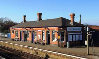
Camborne railway station serves the town of Camborne, Cornwall, England. The station is 313 miles (504 km) from London Paddington via Bristol Temple Meads. It is located on Trevu Road in the town, adjacent to a level crossing and the Railway Hotel.

<span class="mw-page-title-main">Trevenson</span>

Trevenson is in the parish of Carn Brea, between the towns of Camborne and Redruth in Cornwall, United Kingdom.

<span class="mw-page-title-main">Pool, Cornwall</span> Village in west Cornwall, England

Pool is a village in Carn Brea civil parish in west Cornwall, England. It is bypassed by the A30, on the A3047 between Camborne and Redruth, between Tuckingmill and Illogan Highway.

<span class="mw-page-title-main">Camborne Redruth Community Hospital</span> Hospital in England

The Camborne Redruth Community Hospital is a National Health Service hospital in Cornwall, England. It is managed by Cornwall Partnership NHS Foundation Trust.

<span class="mw-page-title-main">Camborne and Redruth Tramways</span>

The Camborne and Redruth Tramways company operated an electric freight and passenger tramway service in the Cornish towns of Camborne and Redruth between 1902 and 1934.

<span class="mw-page-title-main">Outline of Cornwall</span> Overview of and topical guide to Cornwall

The following outline is provided as an overview of and topical guide to Cornwall: Cornwall – ceremonial county and unitary authority area of England within the United Kingdom. Cornwall is a peninsula bordered to the north and west by the Celtic Sea, to the south by the English Channel, and to the east by the county of Devon, over the River Tamar. Cornwall is also a royal duchy of the United Kingdom. It has an estimated population of half a million and it has its own distinctive history and culture.

Presented below is an alphabetical index of articles related to Cornwall:

<span class="mw-page-title-main">Corn exchanges in England</span> Commodity trading halls in Great Britain

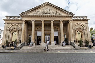
Corn exchanges are distinct buildings which were originally created as a venue for corn merchants to meet and arrange pricing with farmers for the sale of wheat, barley, and other corn crops. The word "corn" in British English denotes all cereal grains, such as wheat and barley. With the repeal of the Corn Laws in 1846, a large number of corn exchanges were built in England, particularly in the corn-growing areas of Eastern England.

<span class="mw-page-title-main">ABC Radio Studios, Rockhampton</span> Historic site in Queensland, Australia

ABC Radio Studios are heritage-listed radio studios at 236 Quay Street, Rockhampton City, Rockhampton, Rockhampton Region, Queensland, Australia. It was added to the Australian Commonwealth Heritage List on 14 September 2009.

<span class="mw-page-title-main">Pool and Tehidy (electoral division)</span> Electoral division of Cornwall in the UK

Pool and Tehidy is an electoral division of Cornwall in the United Kingdom which returns one member to sit on Cornwall Council. The current councillor is Conservative Philip Desmonde.

<span class="mw-page-title-main">Willenhall Library</span> Municipal building in Willenhall, West Midlands, England

Willenhall Library, formerly Willenhall Town Hall, is a municipal building in Walsall Street in Willenhall, West Midlands, England. The building, which was the headquarters of Willenhall Urban District Council, is a locally listed building.

<span class="mw-page-title-main">Minehead Town Hall</span> Municipal building in Minehead, Somerset, England

Minehead Town Hall is a municipal building in The Parade, Minehead, Somerset, England. The structure, which is the meeting place of Minehead Town Council, is a Grade II listed building.

<span class="mw-page-title-main">Baldock Town Hall</span> Municipal building in Baldock, Hertfordshire, England

Baldock Town Hall is a municipal building in the High Street, Baldock, Hertfordshire, England. The structure, which now operates as an arts and heritage centre, is a locally listed building.

<span class="mw-page-title-main">Old Town Hall, Leighton Buzzard</span> Municipal building in Leighton Buzzard, Bedfordshire, England

The Old Town Hall is a municipal building in the Market Square, Leighton Buzzard, Bedfordshire, England. The town hall, which is currently used as a restaurant, is a Grade II listed building.

<span class="mw-page-title-main">Tetbury Market House</span> Municipal building in Tetbury, Gloucestershire, England

Tetbury Market House, also known as Tetbury Town Hall, is a municipal building in the Market Place, Tetbury, Gloucestershire, England. The building, which was used both as a market house and as a town hall until the late 19th century, is a Grade I listed building.

<span class="mw-page-title-main">Old Town Hall, Poulton-le-Fylde</span> Municipal building in Poulton-le-Fylde, Lancashire, England

The Old Town Hall is a building on Church Street in the market town of Poulton-le-Fylde in Lancashire, England. The building, which is located just beyond the northern end of Market Place, started life as a public house before becoming a municipal building and then reverting to use as a public house.

<span class="mw-page-title-main">Abram Council Offices</span> Municipal building in Abram, Greater Manchester, England

Abram Council Offices is a municipal building in Warrington Road, Abram, Greater Manchester, England. The building is currently used as private apartments.

<span class="mw-page-title-main">Loftus Town Hall</span> Municipal building in Loftus, North Yorkshire, England

Loftus Town Hall is a municipal building in Water Lane in Loftus, North Yorkshire, England. The structure, which accommodates the offices and meeting place of Loftus Town Council, is a grade II listed building.

References

  1. 1 2 Historic England. "Old Council Offices (1142644)". National Heritage List for England . Retrieved 29 May 2023.
  2. Kelly's Directory of Devonshire & Cornwall. Kelly's Directories. 1914.
  3. "Camborne Local Board". Royal Cornwall Gazette. 22 July 1887. p. 2. Retrieved 29 May 2023.
  4. "Camborne UD". Vision of Britain. Retrieved 29 May 2023.
  5. Cahill, Nick J (2002). Cornwall Industrial Settlements Initiative. Camborne (Camborne-Redruth Area). Truro: Cornwall County Council.
  6. "Old Ordnance Survey Map" . Retrieved 29 May 2023.
  7. "Cornish Buildings Group" (PDF). Cornwall Heritage. 2010. p. 6. Retrieved 29 May 2023.
  8. "Council Chamber 1906". Francis Frith. Retrieved 29 May 2023.
  9. "New use for old building". Falmouth Packet. 5 November 2006. Retrieved 29 May 2023.
  10. "Camborne in Cornwall" (PDF). Great British Railways. p. 6. Retrieved 29 May 2023.
  11. "Camborne Old Fire Station". Firestations.org. Retrieved 29 May 2023.
  12. "Chairman's Dinner". Camborne Redruth Conservative Association. 9 November 2012. Retrieved 29 May 2023.
  13. "Camborne Town Centre Conservation Area Appraisal and Management Strategy" (PDF). 1 March 2010. p. 54. Retrieved 29 May 2023.
  14. "Restoring the Past". BBC. Retrieved 29 May 2023.