
Worcestershire is a county in the West Midlands of England. The area that is now Worcestershire was absorbed into the unified Kingdom of England in 927, at which time it was constituted as a county.
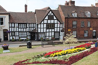
Upton-upon-Severn is a town and civil parish in the Malvern Hills District of Worcestershire, England. Lying on the A4104, the 2011 census recorded a population of 2,881 for the town.
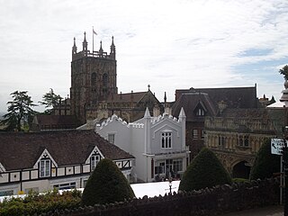
Malvern Hills is a local government district in Worcestershire, England. Its council is based in the town of Malvern, and its area covers most of the western half of the county, including the outlying towns of Tenbury Wells and Upton-upon-Severn. It was originally formed in 1974 and was subject to a significant boundary reform in 1998. In the 2011 census the population of the Malvern Hills district was 74,631.

North Malvern is a suburb of Malvern, Worcestershire, England. It nestles on the northern slopes of the Malvern Hills. It is a contiguous urban extension of Link Top, and other neighbouring centres of population are Great Malvern, Malvern Link, West Malvern and the former village of Cowleigh. It is part of the civil parish of Malvern, administered by the Malvern Hills District, and is included in the informal region known as The Malverns.
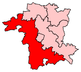
West Worcestershire is a constituency in Worcestershire represented in the House of Commons of the UK Parliament since 2010 by Harriett Baldwin, a Conservative. The constituency is considered a safe seat for the Conservatives. The constituency boundaries roughly correspond with the Malvern Hills District.

Kidderminster railway station is the main station serving the large town of Kidderminster, Worcestershire, England and the wider Wyre Forest district. The station is operated by West Midlands Trains, and is on the Birmingham to Worcester via Kidderminster Line. Regular commuter services run to Birmingham and Worcester, with several direct daily services to/from London Marylebone. It shares its station approach with the adjacent Severn Valley Railway station.

The A449 is a major road in the United Kingdom. It runs north from junction 24 of the M4 motorway at Newport in South Wales to Stafford in Staffordshire.

Madresfield is a village and civil parish in the administrative district of Malvern Hills in the county of Worcestershire, England. It is located about two miles east of Malvern town centre at the foot of the Malvern Hills and is less than two miles from the River Severn. Surrounded by farms and common land, it has a clear view of the entire range of the Malvern Hills, and is part of the informal region referred to as The Malverns.
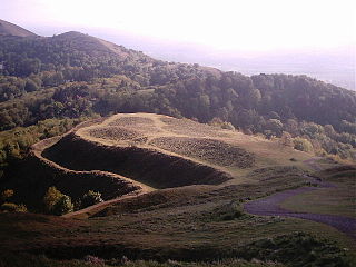
The Herefordshire Beacon is one of the highest peaks of the Malvern Hills, and is high enough to be classified as a mountain. It is surrounded by a British Iron Age hill fort earthwork known as British Camp. The fort subsequently had a ringwork and bailey castle built inside its boundary and there is evidence of 120 huts in the area. British Camp has been a scheduled monument since 1923.

Worcester Foregate Street railway station, opened by the Great Western Railway in 1860 in the centre of Worcester, England, is the smaller of the two stations serving the city, but more centrally located. The other station, Worcester Shrub Hill, is to the east. A third station, Worcestershire Parkway, is located just outside the city to the south-east.

British Camp is an Iron Age hill fort located at the top of Herefordshire Beacon in the Malvern Hills. The hill fort is protected as a Scheduled Ancient Monument and is owned and maintained by Malvern Hills Conservators. The fort is thought to have been first constructed in the 2nd century BC. A Norman castle was built on the site.
The Severn Valley is a rural area of the West Midlands region of England, through which the River Severn runs and the Severn Valley Railway steam heritage line operates, starting at its northernmost point in Bridgnorth, Shropshire and running south for 16 miles (26 km) to Ribbesford, a few miles south of Bewdley, Worcestershire in the Wyre Forest.

Welland is a village and civil parish in the administrative district of Malvern Hills in the county of Worcestershire, England. It has a combined parish council with Little Malvern, with 9 of the 11 councillors. It is about 6 miles (9.7 km) from the town of Malvern, 15 miles from the city of Worcester, and 18 miles from the city of Gloucester. It is surrounded by farms and common land, and is part of the informal region referred to as The Malverns.

Severn Stoke is an English village and civil parish in the Malvern Hills District, in the south of the county of Worcestershire, alongside the A38 trunk road. It had a population of 611 in 2011.

Hartlebury Common is an area of lowland heath in north Worcestershire, England, situated just outside the town of Stourport-on-Severn. Hartlebury Common and Hillditch Coppice are a biological and geological Site of Special Scientific Interest which covers an area of 90.2 hectares . The common supports many varieties of wild plants and insects, especially butterflies and moths. Hartlebury Common and Hillditch Pool are a Local Nature Reserve.
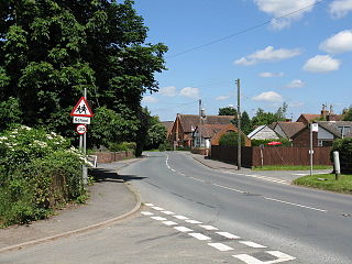
Callow End is a constituent village of the civil parish of Powick in the Malvern Hills District of Worcestershire, England. It is located on the B4424 road about 1 mile (1.6 km) to the south of its junction with the main A449 Malvern to Worcester road. The River Severn runs down the eastern side of the village.

Upton-on-Severn railway station was a railway station serving Upton-on-Severn in the English county of Worcestershire.

North Hill is the second highest point of the range of Malvern Hills that runs about 13 kilometres (8.1 mi) north-south along the Herefordshire-Worcestershire border, although North Hill lies entirely within Worcestershire. It has an elevation of 397 metres (1,302 ft), making it the highest point of the Worcestershire Way.

Wyche, often referred to locally as The Wyche, is a village and a suburb of the town of Malvern, Worcestershire, England, and part of the civil parish of Malvern Wells. It is situated approximately 1 mile (1.6 km) south of Great Malvern, the town's centre, on the B4218 road that runs from Malvern to Colwall.
