Portland is the most populous city in the U.S. state of Maine and the seat of Cumberland County. Portland's population was 68,408 in April 2020. The Greater Portland metropolitan area has a population of approximately 550,000 people. Historically tied to commercial shipping, the marine economy, and light industry, Portland's economy in the 21st century relies mostly on the service sector. The Port of Portland is the second-largest tonnage seaport in the New England area as of 2019.

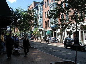
Exchange Street is a main commercial thoroughfare in the Old Port of Portland, Maine, United States. Originally laid out in 1724, today it features a number of designer clothing stores, as well as several small, locally owned businesses, including Sherman's Maine Coast Books. It runs, one-way, for around 0.24 miles (0.39 km), from Congress Street in the northwest to Fore Street in the southeast. Its main intersections are with Congress Street, Federal Street, Middle Street and Fore Street.
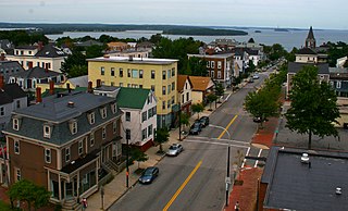
Munjoy Hill is both a neighborhood and prominent geographical feature of Portland, Maine. It is located east of downtown and south of East Deering, the neighborhood it is connected to by Tukey's Bridge. The neighborhood historically had a large Irish and Italian American population.

Downtown Norfolk serves as the traditional center of commerce, government, and culture in the Hampton Roads region. Norfolk, Virginia's downtown waterfront shipping and port activities historically played host to numerous and often noxious port and shipping-related uses. With the advent of containerized shipping in the mid-19th century, the shipping uses located on Norfolk's downtown waterfront became obsolete as larger and more modern port facilities opened elsewhere in the region. The vacant piers and cargo warehouses eventually became a blight on downtown and Norfolk's fortunes as a whole. But in the second half of the century, Norfolk had a vibrant retail community in its suburbs; companies like Smith & Welton, High's, Colonial Stores, Goldman's Shoes, Lerner Shops, Hofheimer's, Giant Open Air, Dollar Tree and K & K Toys were regional leaders in their respective fields. Norfolk was also the birthplace of Econo-Travel, now Econo Lodge, one of the nation's first discount motel chains.
Kennedy Park is a neighborhood in East Bayside in downtown Portland, Maine, built around a park, athletic fields, basketball courts, a playground and the Boyd Street Urban Garden.

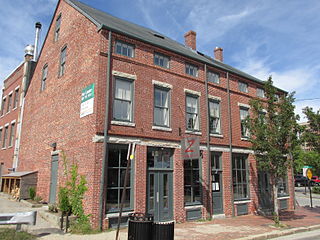
Mariner's Church is a historic church and commercial building at 368–374 Fore Street in Portland, Maine. Built in 1828, the Greek Revival building historically served as both a church and marketplace. It was for many years the city's largest commercial building, and survived the city's great 1866 fire. It was listed on the National Register of Historic Places in 1973.
Portland, Maine, is home to many neighborhoods.
Commercial Street is a downtown street in the Old Port of Portland, Maine, United States. It is part of U.S. Route 1A. It became the Old Port's waterfront in the early 20th century, replacing Fore Street, after land was reclaimed from the waters of Casco Bay and the Fore River.

Franklin Street is a four-lane street in Portland, Maine, United States. It is a major corridor for traffic from Interstate 295 to Portland's downtown, Old Port, and to other neighborhoods located on the Portland peninsula. Part of U.S. Route 1A, it is around 0.77 miles (1.24 km) long, running between Marginal Way in the northwest and Commercial Street in the southeast.
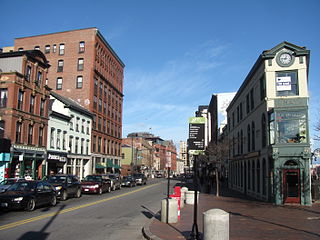
Congress Street is the main street in Portland, Maine. Around 5.77 miles (9.29 km) long, it stretches from County Road, Portland's southwestern border with Westbrook, through a number of neighborhoods, before ending overlooking the Eastern Promenade on Munjoy Hill. In March 2009, the Portland City Council designated much of the inner portion of Congress Street a historic district. The western section of the street includes the city's Arts District.
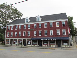
The Tracy-Causer Block is a historic commercial building located at 505-509 Fore Street in the Old Port commercial district of Portland, Maine. Built in 1866 as a mixed-used residential and commercial building, it is a rare surviving example of this type of building in the city. It was listed on the National Register of Historic Places in 1994.
The Dudley Block is a historic mixed-use commercial and residential building in at 28-34 Water Street in downtown Biddeford, Maine. Built in 1848, it is one of the older buildings in the downtown area, and is a fine example of Greek Revival commercial architecture. It was listed on the National Register of Historic Places in 1982, and was included in the Biddeford Main Street Historic District in 2009.

The Portsmouth Downtown Historic District encompasses the historic urban core of Portsmouth, New Hampshire. With a history dating to the 17th century, Portsmouth was New Hampshire's principal seaport and the center of its economy for many decades, and the architecture of its urban center is reflective of nearly four centuries of history. The district is roughly L-shaped, radiating from the downtown Market Square area to South Street in the south and Madison and Columbia streets in the west, with more than 1,200 historically significant buildings. It was listed on the National Register of Historic Places in 2017. The district includes 35 previous listings on the National Register, and five National Historic Landmarks.

Naito Parkway is a major thoroughfare of Portland in the U.S. state of Oregon. It was formerly known as Front Avenue and Front Street and was renamed in 1996 to honor Bill Naito. It runs between SW Barbur Boulevard and NW Front Avenue, and adjacent to Tom McCall Waterfront Park through Downtown Portland.
The Hollow Reed was a vegetarian restaurant in the Old Port district of Portland, Maine. It opened on February 7, 1974, and closed in 1981, and is cited for its influence on the city's notable restaurant culture.
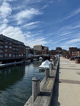
Long Wharf is a historic wharf in Portland, Maine, on the edge of the Fore River. It stands across Commercial Street, between Market Street and Moulton Street and, on the waterfront side, between Portland Pier and Chandler's Wharf.

Fore Street is a downtown street in Portland, Maine, United States. Dating to 1724, it runs for around 1 mile (1.6 km), from the Eastern Promenade on Munjoy Hill in the northeast to Pleasant Street in the southwest. Near its midsection, Fore Street crosses Franklin Street. It splits briefly at Boothby Square, shortly after passing the United States Custom House. The street passes through the Old Port district.

Middle Street is a downtown street in Portland, Maine, United States. Dating to 1724, it runs for around 0.46 miles (0.74 km), from an intersection with Union Street, Spring Street and Temple Street in the southwest, to Hancock Street, at the foot of Munjoy Hill, in the northeast. It formerly originated at what was then known as Market Square, but 20th-century redevelopment saw the section between Monument Square and Free Street pedestrianized, and the remaining section—around The Maine Lobsterman monument on Temple Street—erased.

India Street is a downtown street and neighborhood in Portland, Maine, United States. Situated near the western foot of Munjoy Hill, it runs for around 0.28 miles (0.45 km), from Congress Street in the northwest to Commercial Street and Thames Street in the southeast. It was the city's first street, and the location of the first settlement of European immigrants to the city in the 17th century. There are thirty handmade bricks in the sidewalk commemorating the neighborhood's notable events. In 1680, when Thomas Danforth was Deputy Governor of the Massachusetts Bay Colony, the street was known as Broad Street. After the incorporation of the Town of Falmouth in 1718, the street was known as High King Street.

Moulton Street is a historic downtown street in Portland, Maine, United States. Situated in the heart of the Old Port, it runs for around 233 feet (71 m), from Fore Street in the northwest to Commercial Street in the southeast. One-way from Fore Street, its surface is cobblestoned, with brick sidewalks. The street is named for William H. Moulton, president of the Cumberland Bank, which stood at the corner of Moulton and Commercial.