Old Saint Paul's Cemetery

Last updated
St. Paul's Cemetery
Old Saint Paul.jpg
Old Saint Paul's Cemetery
Location Redwood Street and Martin Luther King Jr. Blvd., Baltimore, Maryland
Coordinates 39°17′16.2″N76°37′39″W / 39.287833°N 76.62750°W / 39.287833; -76.62750
Area2.4 acres (0.97 ha)
NRHP reference No. 88000746 [1]
Significant dates
Added to NRHPJune 30, 1988
Designated BCL1986

Old Saint Paul's Cemetery is a cemetery located in downtown Baltimore, Maryland, United States. It is noted for the several important historical figures that are interred in its grounds. [2]

Contents

It was listed on the National Register of Historic Places in 1988. [1]

History

The first cemetery of Saint Paul's Church (Protestant Episcopal) in Baltimore was located at the future intersection of Sollers Road and North Point Road in what is now the area of Dundalk in southeastern Baltimore County. The original small church of St. Paul's Parish of the established Church of England was one of the "Original Thirty" parishes designated for the colonial Province of Maryland and was founded in 1692 and considered to be one of the oldest churches in the State. In 1730, the Parish Church of St. Paul's was moved from near Colgate Creek on the "Patapsco Neck" peninsula to the new burgeoning town of Baltimore overlooking "The Basin" at the head of the Patapsco River on its Northwest Branch, and Lot #19 was purchased in the "Original Survey" of that year by county surveyor Phillip Jones from Charles Carroll of Annapolis.

As the designated parish for the new Baltimore County, which then included most of northeastern Maryland when it was "erected" (established) in 1659, the first St. Paul's was located around the vicinity of the lower Colgate Creek which flowed into the Patapsco River and is assumed that the cemetery would be located somewhere nearby. The church site was probably in the area of the future aviation sites of "Logan Field", "Baltimore Municipal Airport" (later known as "Harbor Field" after World War II), and now the grounds of the "Dundalk Marine Terminal" and "Sea Girt Marine Terminal" of the facilities for the Port of Baltimore Laid out in 1692, along with the Parish, this churchyard is the oldest cemetery that is known to have existed in the Baltimore metropolitan area.

About 1760, those remains were exhumed and moved to the new Saint Paul's Burial Ground which surrounded the original church, which was the first building in the new town to be built of brick and completed after 9 years of work in 1739 at Forest Street (now North Charles Street) and the intersecting east–west lane which later became East Saratoga Street after the American Revolution to commemorate the famous "turning point" battle in 1777 along the Hudson River in New York State. To the east lay the Jones Falls Bluffs which stood from 1739 to 1817, over the southwestward "loop" of the stream before its course was further north. Below the cliffs was another lane which was named for the church as "Saint Paul's Lane" (to become St. Paul Street and in the southern portion after construction of the terraced "Preston Gardens" in the 1920s, became known as Saint Paul Place. To the south at the then limit of the lot was laid out New Church Street which later became East and West Lexington Streets (also after the Revolution), one block south of the later church buildings. That building was replaced by another in (1812, 1813–17?) of Greek Revival design by famous local architect Robert Cary Long, Jr. which burned in 1854 and was later replaced by the present building in 1856 which fills that entire property, at the current intersection of North Charles and East Saratoga Streets.

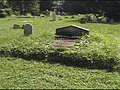
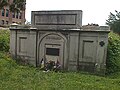
In the late 18th century, the Vestry of Old St. Paul's Church was faced with the need for a third cemetery. Cemeteries had never been viewed as good neighbors, aside from the fact that they contained the bodies and souls of the departed (who, it was believed, had the ability to wander the land), they could become unsightly and even unhealthy.

Therefore, a new cemetery site was purchased in 1800 on the western edge of town. This site is bordered on the west by Martin Luther King Jr. Boulevard (Cove Street at the time of purchase, later Fremont Avenue), Lombard Street on the south, and Redwood Street (formerly German Street) on the north. Several members of the Vestry owned a great deal of undeveloped property in this area.

Church member Samuel Smythe purchased 2.8 acres (11,000 m2) of land from the heirs of Alexander Robinson, whose house is found on the 1802 "Hanna and Warner" map of Baltimore, directly across German Street from the Smythe purchase. The land was subsequently bought by the Church. Many of the parishioners immediately bought grave lots and began construction of vaults and plots.

When Martin Luther King Jr. Boulevard was constructed, during the mid-1980s, one end of this cemetery was lost on the west side and the remains and markers were moved within the remaining walled cemetery that now sits surrounded by the University of Maryland, Baltimore campus.

Persons of note interred

See also

Related Research Articles

<span class="mw-page-title-main">Baltimore County, Maryland</span> County in Maryland, United States

Baltimore County is the third-most populous county in the U.S. state of Maryland and is part of the Baltimore metropolitan area. Baltimore County is part of the Northeast megalopolis, which stretches from Northern Virginia northward to Boston. Baltimore County hosts a diversified economy, with particular emphasis on education, government, and health care. As of the 2020 census, the population was 854,535.

<span class="mw-page-title-main">Charles Carroll (barrister)</span> American politician (1723-1783)

Charles Carroll was an American statesman from Annapolis, Maryland. He was the builder of the Baltimore Colonial home Mount Clare (1760), and a delegate to the Second Continental Congress in 1776 and 1777.

<span class="mw-page-title-main">Patapsco River</span> River in Maryland, United States

The Patapsco River mainstem is a 39-mile (63 km) river in central Maryland that flows into the Chesapeake Bay. The river's tidal portion forms the harbor for the city of Baltimore. With its South Branch, the Patapsco forms the northern border of Howard County, Maryland. The name "Patapsco" is derived from the Algonquian pota-psk-ut, which translates to "backwater" or "tide covered with froth."

<span class="mw-page-title-main">Fell's Point, Baltimore</span> Neighborhood of Baltimore in Maryland, United States

Fell's Point is a historic waterfront neighborhood in southeastern Baltimore, Maryland. It was established around 1763 along the north shore of the Baltimore Harbor and the Northwest Branch of the Patapsco River. The area has many antique, music, and other stores, restaurants, coffee bars, a municipal markethouse with individual stalls, and over 120 pubs. Located 1.5 miles east of Baltimore's downtown central business district and the Jones Falls stream, Fells Point has a maritime past and the air of a seafaring town.

<span class="mw-page-title-main">Westminster Hall and Burying Ground</span> Historic district in Maryland, United States

Westminster Hall and Burying Ground is a graveyard and former church located at 519 West Fayette Street in Baltimore, Maryland, United States. It is currently part of the grounds of the University of Maryland's School of Law. It occupies the southeast corner of West Fayette and North Greene Street on the west side of downtown Baltimore. It sits across from the Baltimore VA hospital and is the burial site of Edgar Allan Poe (1809–1849). The complex was declared a national historic district in 1974.

Robert Cary Long Jr. (1810–1849) was the son of a late 18th Century - early 19th Century famous architect Robert Cary Long Sr. of Baltimore, Maryland and was himself a well-known 19th Century architect. Like his father, Cary was based in Baltimore.

Patapsco may refer to:

<span class="mw-page-title-main">St. Charles College (Maryland)</span> Historic district in Maryland, United States

St. Charles College was a minor seminary in Catonsville, Maryland, originally located in Ellicott City, Maryland.

<span class="mw-page-title-main">Ilchester, Maryland</span> Census-designated place in Maryland

Ilchester is an unincorporated community and census-designated place in Howard County, Maryland, United States. The population was 23,476 at the 2010 census. It was named after the village of Ilchester in the English county of Somerset.

<span class="mw-page-title-main">Fort Howard (Maryland)</span> Former fort in Baltimore County, Maryland, US

Fort Howard was a military installation located on the North Point peninsula, overlooking the main channel of the Patapsco River leading into the harbor of Baltimore, Maryland, USA. Although militarily important since the early 19th century, its surviving elements and name date to the Spanish–American War. It was named by Elihu Root, Secretary of War under President Theodore Roosevelt, in 1902 after Colonel John Eager Howard (1752–1827). The installation earned the nickname the "Bulldog at Baltimore's Gate", serving as the coastal artillery headquarters for Baltimore, Maryland. Fort Howard's historical significance is its military connection with the War of 1812, the Spanish–American War, and World War II.

St. Paul Street and Calvert Street are a one-way pair of streets in Downtown Baltimore and areas north. The streets, which are part of Maryland Route 2, are two of Baltimore's best-known streets in the downtown area.

<span class="mw-page-title-main">St. Peter the Apostle Church</span> Historic church in Maryland, United States

St. Peter the Apostle Church was a Roman Catholic church located within the Archdiocese of Baltimore in Baltimore, Maryland. Constructed at the northwest corner of Hollins and South Poppleton Streets and, it was often referred to as "The Mother Church of West Baltimore."

<span class="mw-page-title-main">St. Paul's Church (Fairlee, Maryland)</span> Historic church in Maryland, United States

St. Paul's Church is an historic Episcopal church located near the village of Fairlee, southwest of Chestertown, Kent County, Maryland. St. Paul's Church is one of the original thirty parishes created in 1692 by an Act of the General Assembly declaring the Church of England as the established religion of the Province of Maryland. The Georgian-styled building, completed in 1713, is the second-oldest Episcopal church on the Eastern Shore of Maryland.

<span class="mw-page-title-main">St. Paul's Episcopal Church (Baltimore, Maryland)</span> Historic church in Maryland, United States

St. Paul's Protestant Episcopal Church, more commonly called Old St. Paul's Church today, is a historic Episcopal church located at 233 North Charles Street at the southeast corner with East Saratoga Street, in Baltimore, Maryland, near "Cathedral Hill" on the northern edge of the downtown central business district to the south and the Mount Vernon-Belevedere cultural/historic neighborhood to the north. It was founded in 1692 as the parish church for the "Patapsco Parish", one of the "original 30 parishes" of the old Church of England in colonial Maryland.

<span class="mw-page-title-main">St. Paul's Church Rectory</span> United States historic place

St. Paul's Church Rectory, located a block west of Old St. Paul's Episcopal Church is a historic Episcopal rectory located on steep "Cathedral Hill" at the northeast corner of Cathedral Street and West Saratoga Streets in downtown Baltimore, Maryland, United States. In the rear of the old rectory is a small alley-like extension of West Pleasant Street and to the east behind the North Charles Street former residences and now commercial structures, is another small alley extension of Little Sharp Street.

Mercy Medical Center is a hospital located in Baltimore, Maryland. Mercy Medical Center has been recognized by U.S. News & World Report's "Best Hospitals" ratings for 2022–2023. Among Adult Specialties, National Rankings, Mercy was rated as High Performing in Orthopedics. The High Performing rating is in recognition of care that was significantly better than the national average, as measured by factors such as patient outcomes.

<span class="mw-page-title-main">Baltimore Municipal Airport</span> Airport near Baltimore, Maryland, US

<span class="mw-page-title-main">Mount Winans, Baltimore</span> Neighborhood of Baltimore in Maryland, United States

"Mount Winans" is a mixed-use residential, commercial and industrial neighborhood in the southwestern area of the City of Baltimore in Maryland. Its north, south and east boundaries are marked by the various lines of track of the CSX Railroad. In addition, Hollins Ferry Road running to the south towards suburban Baltimore County in the southwest and further connecting with adjacent Anne Arundel County to the southeast, draws its western boundary.

<span class="mw-page-title-main">All Saints Church (Frederick, Maryland)</span> Church in Maryland, United States

All Saints Church, or All Saints Episcopal Church, founded in 1742, is a historic Episcopal church now located at 106 West Church Street in the Historic District of Frederick, Maryland. It is the seat of All Saints Parish, Diocese of Maryland, which covers most of Frederick County, Maryland and once covered most of Western Maryland.

References

  1. 1 2 "National Register Information System". National Register of Historic Places . National Park Service. July 9, 2010.
  2. Mrs. Washington Bowie and R. Kent Lancaster (October 1986). "National Register of Historic Places Registration: Old Saint Paul's Cemetery" (PDF). Maryland Historical Trust. Retrieved 2016-04-01.
  3. "Funeral of Col. Jacob G. Davies". The Baltimore Sun . 1857-10-10. p. 1. Retrieved 2022-08-07 via Newspapers.com. Open Access logo PLoS transparent.svg