Current listings
| [4] | Name on the Register | Image | Date listed [5] | Location | District [6] | Description |
|---|---|---|---|---|---|---|
| 1 | David Bachrach House |  | September 5, 1985 (#85001947) | 2406-2408 Linden Ave. 39°18′51″N76°38′10″W / 39.314167°N 76.636111°W | Central | |
| 2 | Baltimore City College |  | August 11, 1983 (#83002925) | 530 North Howard Street 39°17′46″N76°37′13″W / 39.296113°N 76.620225°W | Central | Served the third oldest public high school in America - founded 1839, which occupied several structures through its history. Here constructed 1893-1895 in Richardson Romanesque Revival style, facing north towards West Centre Street, designed by local prominent architectural firm of Baldwin & Pennington, (Ephraim Francis Baldwin, [1846-1916], and Josias Pennington, [1854-1929]), to replace earlier English Tudor Revival style building (which faced east towards North Howard Street) by George A. Frederick, [1842-1924], (also designer at same time of massive Baltimore City Hall, 1867-1875, his "flagship project") in 1874-1875 on same site, which was later undermined and collapsed from construction by the Baltimore and Ohio Railroad's Howard Street Tunnel in 1891-1892. Occupied by B.C.C. until 1928, when the school moved to its present hill-top campus with stone Collegiate Gothic Revival "Castle on the Hill" at 33rd Street and The Alameda in northeast Baltimore. Its 1895 home was located next to the first downtown campus of The Johns Hopkins University along North Howard Street, between West Centre, Little Ross and West Monument Streets, from 1876 to c. 1914, until moving to Homewood. City College served as an unofficial "prep school" for J.H.U. during the late 19th and early 20th Centuries. |
| 3 | Baltimore City Hall | 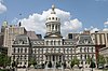 | May 8, 1973 (#73002180) | 100 North Holliday Street 39°17′27″N76°36′39″W / 39.290833°N 76.610833°W | Central | |
| 4 | Baltimore City Passenger Railway Power House and Car Barn |  | September 9, 1998 (#98001156) | 1711-1717 N. Charles St. 39°18′33″N76°36′59″W / 39.309167°N 76.616389°W | Central | |
| 5 | Baltimore College of Dental Surgery |  | May 8, 1987 (#87000697) | 429-433 N. Eutaw St. 39°17′41″N76°37′16″W / 39.294722°N 76.621111°W | Central | The building is now used for retail businesses |
| 6 | Baltimore Equitable Society |  | October 6, 1977 (#77001528) | 21 N. Eutaw St. 39°17′28″N76°37′16″W / 39.291111°N 76.621111°W | Central | |
| 7 | Baltimore Federal Savings & Loan Association | November 22, 2022 (#100008034) | 19-25 East Fayette St. 39°17′25″N76°36′51″W / 39.2904°N 76.6143°W | |||
| 8 | Baltimore Gas and Electric Company Building |  | December 29, 2003 (#03001325) | 39 W. Lexington St. 39°17′35″N76°37′02″W / 39.293056°N 76.617222°W | Central | |
| 9 | Baltimore General Dispensary |  | March 18, 1980 (#80001779) | 500 W. Fayette St. 39°17′26″N76°37′22″W / 39.290556°N 76.622778°W | Central | |
| 10 | Baltimore Grand |  | January 14, 2000 (#99001671) | 401 W. Fayette St. 39°17′24″N76°37′17″W / 39.29°N 76.621389°W | Central | |
| 11 | Baltimore Hebrew Congregation Synagogue |  | November 7, 1976 (#76002181) | 1901 Madison Ave. 39°18′29″N76°37′59″W / 39.308056°N 76.633056°W | Central | |
| 12 | Battle Monument |  | June 4, 1973 (#73002181) | Calvert St. between Fayette and Lexington Sts. 39°17′26″N76°36′45″W / 39.290556°N 76.6125°W | Central | |
| 13 | Belvedere Hotel |  | August 29, 1977 (#77001529) | 1 E. Chase St. 39°18′08″N76°36′58″W / 39.302222°N 76.616111°W | Central | |
| 14 | Benson Building |  | March 26, 1980 (#80001782) | 4 E. Franklin St. 39°17′43″N76°36′55″W / 39.295278°N 76.615278°W | Central | |
| 15 | Bolton Hill Historic District |  | September 17, 1971 (#71001031) | Roughly bounded by North Ave., Eutaw Pl., and the Pennsylvania Railroad tracks 39°18′25″N76°37′36″W / 39.306944°N 76.626667°W | Central | |
| 16 | Brewers Exchange |  | March 28, 1985 (#85000652) | 20 Park Ave. 39°17′26″N76°37′06″W / 39.290556°N 76.618333°W | Central | |
| 17 | Brown's Arcade |  | January 17, 1983 (#83002927) | 322-328 N. Charles St. 39°17′36″N76°36′56″W / 39.293333°N 76.615556°W | Central | |
| 18 | Alex Brown Building |  | December 2, 1982 (#82001581) | 135 E. Baltimore St. 39°17′22″N76°36′45″W / 39.289444°N 76.6125°W | Central | |
| 19 | Building at 409 West Baltimore Street |  | December 1, 1994 (#94001395) | 409 W. Baltimore St. 39°17′21″N76°37′18″W / 39.289167°N 76.621667°W | Central | |
| 20 | Building at 419 West Baltimore Street |  | September 30, 1994 (#94001171) | 419 W. Baltimore St. 39°17′21″N76°37′20″W / 39.289167°N 76.622222°W | Central | |
| 21 | Building at 423 West Baltimore Street |  | February 10, 1995 (#94001607) | 423 W. Baltimore St. 39°17′21″N76°37′20″W / 39.289167°N 76.622222°W | Central | |
| 22 | Buildings at 10, 12, 14, and 16 East Chase Street |  | March 10, 1980 (#80001783) | 10, 12, 14, and 16 E. Chase St. 39°18′11″N76°36′56″W / 39.303056°N 76.615556°W | Central | |
| 23 | Buildings at 1601–1830 St. Paul Street and 12–20 E. Lafayette Street |  | December 27, 1984 (#84000502) | 1601–1830 St. Paul St. and 12–20 E Lafayette St. 39°18′33″N76°36′54″W / 39.309167°N 76.615°W | Central | |
| 24 | Business and Government Historic District |  | November 25, 1987 (#87002065) | Roughly bounded by Saratoga St., City Boulevard, and Water, Lombard, and Charles Sts. 39°17′24″N76°36′39″W / 39.29°N 76.610833°W | Central | |
| 25 | Canton House |  | December 13, 1978 (#78003140) | 300 Water St. 39°17′20″N76°36′39″W / 39.288889°N 76.610833°W | Central | |
| 26 | Cathedral Hill Historic District |  | April 27, 1987 (#87000622) | Roughly bounded by Hamilton, Saint Paul, Charles, Saratoga, and Cathedral Sts. 39°17′37″N76°36′58″W / 39.293611°N 76.616111°W | Central | |
| 27 | Cecil Apartments |  | June 30, 2000 (#00000743) | 1123 N. Eutlaw St. 39°18′11″N76°37′29″W / 39.303056°N 76.624722°W | Central | |
| 28 | Chamber of Commerce Building |  | February 2, 1983 (#83002929) | 17 Commerce St. 39°17′20″N76°36′36″W / 39.288889°N 76.61°W | Central | |
| 29 | CHESAPEAKE (lightship) |  | August 1, 1980 (#80000349) | Inner Harbor 39°17′08″N76°36′34″W / 39.285556°N 76.609444°W | Central | |
| 30 | Chinatown Historic District | March 4, 2024 (#100009990) | Bounded by Wilson Alley, Park Avenue, Montague Street, and Tyson Street 39°17′38″N76°37′09″W / 39.2940°N 76.6193°W | Central | ||
| 31 | Commercial Credit Company Building | April 17, 2018 (#100002331) | 300-314 St. Paul Pl. 39°17′34″N76°36′51″W / 39.292677°N 76.614177°W | Central | ||
| 32 | U.S.S. CONSTELLATION |  | October 15, 1966 (#66000918) | Pier 1, Pratt St. 39°17′10″N76°36′42″W / 39.286111°N 76.611667°W | Central | |
| 33 | Continental Trust Company Building |  | February 3, 1983 (#83002930) | 1 S. Calvert St. 39°17′23″N76°36′44″W / 39.289722°N 76.612222°W | Central | |
| 34 | Davidge Hall, University of Maryland |  | April 24, 1974 (#74002212) | 522 W. Lombard St. 39°17′16″N76°37′23″W / 39.287778°N 76.62315°W | Central | Designated a National Historic Landmark September 25, 1997 (as College of Medicine of Maryland, Reference Number 97001275) |
| 35 | Emerson Bromo-Seltzer Tower |  | June 4, 1973 (#73002184) | 312-318 Lombard St. 39°17′16″N76°37′15″W / 39.287778°N 76.620833°W | Central | |
| 36 | Erlanger Buildings |  | March 10, 1980 (#80001785) | 519-531 W. Pratt St. 39°17′10″N76°37′22″W / 39.286111°N 76.622778°W | Central | |
| 37 | Eutaw-Madison Apartment House Historic District |  | May 12, 1983 (#83002931) | 2502 and 2525 Eutaw Pl., and 2601 Madison Ave. 39°18′55″N76°38′18″W / 39.315278°N 76.638333°W | Central | |
| 38 | Faust Brothers Building |  | December 7, 1994 (#94001383) | 307-309 W. Baltimore St. 39°17′21″N76°37′12″W / 39.289167°N 76.62°W | Central | |
| 39 | Federal Office Building | November 15, 2023 (#100009560) | 31 Hopkins Plaza 39°17′17″N76°37′03″W / 39.2881°N 76.6176°W | Central | ||
| 40 | Federal Reserve Bank of Richmond, Baltimore Branch |  | January 27, 1983 (#83002933) | 114 E. Lexington St. 39°17′28″N76°36′47″W / 39.291111°N 76.613056°W | Central | |
| 41 | Fifth Regiment Armory |  | September 25, 1985 (#85002671) | 210-247 W. Hoffman St. 39°18′12″N76°37′19″W / 39.303333°N 76.621944°W | Central | |
| 42 | First Presbyterian Church and Manse |  | June 18, 1973 (#73002186) | 200-210 W. Madison St. 39°17′56″N76°37′08″W / 39.298889°N 76.618889°W | Central | |
| 43 | First Unitarian Church |  | February 11, 1972 (#72001495) | 2-12 W. Franklin St. 39°17′43″N76°36′58″W / 39.295278°N 76.616111°W | Central | |
| 44 | L. Frank & Son Building | | January 19, 1995 (#94001642) | 407 W. Baltimore St. 39°17′21″N76°37′18″W / 39.289167°N 76.621667°W | Central | |
| 45 | Franklin Street Presbyterian Church and Parsonage |  | November 5, 1971 (#71001036) | 100 W. Franklin St. (church), 504 Cathedral St. (parsonage) 39°17′43″N76°37′02″W / 39.295278°N 76.617222°W | Central | |
| 46 | Gandy Belting Company Building |  | October 25, 1984 (#84000085) | 726-734 W. Pratt St. 39°17′11″N76°37′39″W / 39.286389°N 76.6275°W | Central | |
| 47 | Garrett Building |  | December 16, 1982 (#82001586) | 233-239 Redwood St. 39°17′20″N76°36′40″W / 39.288889°N 76.611111°W | Central | |
| 48 | Heiser, Rosenfeld, and Strauss Buildings |  | March 10, 1980 (#80001787) | 32-42 S. Paca St. 39°17′16″N76°37′21″W / 39.287778°N 76.6225°W | Central | |
| 49 | Hippodrome |  | January 14, 2000 (#99001670) | 12 N. Eutaw St. 39°17′23″N76°37′17″W / 39.289722°N 76.621389°W | Central | |
| 50 | Home of the Friendless |  | November 8, 2003 (#03001205) | 1313 Druid Hill Ave. 39°18′08″N76°37′45″W / 39.302222°N 76.629167°W | Central | |
| 51 | Hotel Kernan |  | September 3, 1999 (#99001079) | 306-312 W. Franklin St. 39°17′42″N76°37′15″W / 39.295°N 76.620833°W | Central | |
| 52 | Howard Street Tunnel |  | July 2, 1973 (#73002187) | Beneath Howard St. from Mt. Royal Station to Camden Station 39°18′17″N76°37′15″W / 39.304722°N 76.620833°W | Central | |
| 53 | Hutzler Brothers Palace Building |  | June 7, 1984 (#84001348) | 210-218 N. Howard St. 39°17′32″N76°36′31″W / 39.292222°N 76.608611°W | Central | |
| 54 | Lillie Carroll Jackson House | April 13, 2023 (#100008816) | 1320 Eutaw Pl. 39°18′16″N76°37′38″W / 39.3044°N 76.6271°W | |||
| 55 | Johnston Building |  | September 26, 1994 (#94001166) | 26-30 S. Howard St. 39°17′17″N76°37′11″W / 39.288056°N 76.619722°W | Central | |
| 56 | George Knipp & Brother Building |  | December 1, 1994 (#94001394) | 121 N. Howard St. 39°17′28″N76°37′10″W / 39.291111°N 76.619444°W | Central | |
| 57 | Krug Iron Works |  | April 29, 1982 (#82004747) | 415 W. Saratoga St. 39°17′34″N76°37′20″W / 39.292778°N 76.622222°W | Central | |
| 58 | Lyric Theatre |  | January 23, 1986 (#86000131) | 124 W. Mt. Royal Ave. 39°18′20″N76°37′09″W / 39.305556°N 76.619167°W | Central | A major renovation has occurred. |
| 59 | Madison Avenue Methodist Episcopal Church |  | September 4, 1992 (#92001153) | 1327 Madison Ave. 39°18′14″N76°37′40″W / 39.303889°N 76.627778°W | Central | |
| 60 | Market Center |  | February 4, 2000 (#00000040) | 24 blocks surrounding the junction of Howard and Lexington Sts.; also the block bounded by Druid Hill Ave., West Centre St., North Howard St., West Monument St., and North Eutaw St. 39°17′33″N76°37′15″W / 39.2925°N 76.620833°W | Central | Second set of addresses represent a boundary increase approved August 21, 2023. |
| 61 | Mercantile Deposit and Trust |  | November 5, 2018 (#100003078) | 111 W Baltimore St. 39°17′22″N76°37′03″W / 39.2894°N 76.6175°W | ||
| 62 | Mercantile Trust and Deposit Company |  | March 17, 1983 (#83002935) | 202 E. Redwood St. 39°17′21″N76°36′45″W / 39.289167°N 76.6125°W | Central | |
| 63 | Congressman Parren J. Mitchell House | June 29, 2023 (#100009062) | 1805 Madison Ave. 39°18′26″N76°37′55″W / 39.3073°N 76.6320°W | |||
| 64 | Mother Seton House |  | June 13, 1972 (#72001496) | 600 N. Paca St. 39°17′44″N76°37′23″W / 39.295556°N 76.623056°W | Central | |
| 65 | Mount Royal Station | 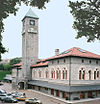 | June 18, 1973 (#73002191) | 1400 Cathedral St. 39°18′20″N76°37′14″W / 39.305556°N 76.620556°W | Central | |
| 66 | Mount Vernon Place Historic District |  | November 11, 1971 (#71001037) | Mount Vernon Pl. and Washington Pl. 39°17′52″N76°36′56″W / 39.297778°N 76.615556°W | Central | |
| 67 | Mount Vernon Place United Methodist Church and Asbury House |  | September 17, 1971 (#71001038) | 2-10 E. Mount Vernon Place 39°17′53″N76°36′55″W / 39.298056°N 76.615278°W | Central | |
| 68 | NOBSKA (steamship) |  | May 2, 1974 (#74002216) | Inner harbor Coordinates missing | Central | Scrapped in 2006 |
| 69 | Odd Fellows Hall |  | March 25, 1980 (#80001789) | 300 Cathedral St. 39°17′35″N76°37′02″W / 39.293056°N 76.617222°W | Central | |
| 70 | Old National Pike Milestones | 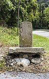 | November 27, 1975 (#75002107) | U.S. Route 40 39°25′13″N77°16′01″W / 39.420278°N 77.266944°W | TBD, perhaps multiple | [ citation needed ] |
| 71 | Old Pine Street Station |  | January 3, 1985 (#85000018) | 214 N. Pine St. 39°17′30″N76°37′40″W / 39.291667°N 76.627778°W | Central | |
| 72 | Old Roman Catholic Cathedral |  | October 1, 1969 (#69000330) | 401 Cathedral St. 39°17′43″N76°36′58″W / 39.295278°N 76.616111°W | Central | |
| 73 | One Charles Center |  | July 13, 2000 (#00000745) | 100 N. Charles St. 39°17′45″N76°37′22″W / 39.295833°N 76.622778°W | Central | |
| 74 | Orchard Street United Methodist Church |  | November 12, 1975 (#75002096) | 510 Orchard St. 39°17′51″N76°37′28″W / 39.2975°N 76.624444°W | Central | |
| 75 | Otterbein Church |  | October 28, 1969 (#69000324) | 112 W. Conway St. 39°17′04″N76°37′02″W / 39.284444°N 76.617222°W | Central | |
| 76 | Paca Street Firehouse |  | October 28, 1983 (#83003631) | 106 N. Paca St. 39°17′27″N76°36′44″W / 39.290833°N 76.612222°W | Central | |
| 77 | Pascault Row |  | January 29, 1973 (#73002193) | 651-665 W. Lexington St. 39°17′28″N76°37′35″W / 39.291111°N 76.626389°W | Central | |
| 78 | Peale's Baltimore Museum | 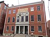 | October 15, 1966 (#66000915) | 225 N. Holliday St. 39°17′31″N76°36′38″W / 39.291944°N 76.610556°W | Central | |
| 79 | Pennsylvania Station | 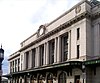 | September 12, 1975 (#75002097) | 1525 N. Charles St. 39°18′28″N76°36′57″W / 39.307778°N 76.615833°W | Central | |
| 80 | Perkins Square Gazebo |  | July 28, 1983 (#83002937) | George St. and Myrtle Ave. 39°17′44″N76°37′45″W / 39.295556°N 76.629167°W | Central | |
| 81 | Pratt Street Power Plant |  | April 9, 1987 (#87000564) | 601 E. Pratt St. 39°17′10″N76°36′27″W / 39.286111°N 76.6075°W | Central | |
| 82 | President Street Station | 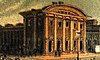 | September 10, 1992 (#92001229) | Junction of President and Fleet Sts. 39°17′02″N76°36′10″W / 39.283889°N 76.602778°W | Central | |
| 83 | Ira Remsen House |  | May 15, 1975 (#75002102) | 214 Monument St. 39°17′51″N76°37′10″W / 39.2975°N 76.619444°W | Central | |
| 84 | Reservoir Hill Historic District | 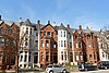 | December 23, 2004 (#04001376) | North Ave., Madison Ave., Druid Park Lake Dr., and Mt. Royal Terrace 39°18′54″N76°38′00″W / 39.315°N 76.633333°W | Central | |
| 85 | Rieman Block |  | June 7, 1984 (#84001350) | 617-631 W. Lexington St. 39°17′28″N76°37′31″W / 39.291111°N 76.625278°W | Central | |
| 86 | Henry August Rowland House |  | May 15, 1975 (#75002098) | 915 Cathedral St. 39°18′02″N76°37′02″W / 39.300505°N 76.617358°W | Central | |
| 87 | St. Mary's Seminary Chapel | 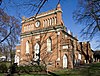 | November 11, 1971 (#71001046) | 600 N. Paca St. 39°17′45″N76°37′23″W / 39.295833°N 76.623056°W | Central | |
| 88 | St. Paul's Church Rectory |  | March 20, 1973 (#73002197) | 24 W. Saratoga St. 39°17′34″N76°36′57″W / 39.292778°N 76.615833°W | Central | |
| 89 | St. Paul's Protestant Episcopal Church | 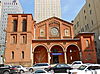 | March 30, 1973 (#73002198) | 233 N. Charles St. 39°17′31″N76°36′54″W / 39.291944°N 76.615°W | Central | |
| 90 | Sanitary Laundry Company Building |  | October 14, 1994 (#94001213) | 118-120 N. Paca St. 39°17′27″N76°37′22″W / 39.290833°N 76.622778°W | Central | |
| 91 | Seton Hill Historic District |  | July 30, 1975 (#75002099) | Bounded by Pennsylvania Ave. and Franklin, Eutaw, McCulloh, and Orchard Sts. 39°17′47″N76°37′24″W / 39.296389°N 76.623333°W | Central | |
| 92 | Seven-Foot Knoll Lighthouse |  | August 22, 1989 (#89001096) | Pier 5, Inner Harbor 39°17′02″N76°36′21″W / 39.283889°N 76.605833°W | Central | |
| 93 | Sharp Street Memorial United Methodist Church and Community House |  | July 21, 1982 (#82004749) | 508-516 Dolphin St. and 1206-1210 Etting St. 39°18′03″N76°37′44″W / 39.300833°N 76.628889°W | Central | |
| 94 | Standard Oil Building |  | December 1, 2000 (#00001461) | 501 St. Paul St. 39°17′43″N76°36′49″W / 39.295278°N 76.613611°W | Central | |
| 95 | Stewart's Department Store |  | September 3, 1999 (#99001078) | 226-232 W. Lexington St. 39°17′31″N76°37′10″W / 39.291944°N 76.619444°W | Central | |
| 96 | Swiss Steam Laundry Building |  | June 20, 1985 (#85001271) | 100-102 N. Greene St. 39°17′25″N76°37′29″W / 39.290278°N 76.624722°W | Central | |
| 97 | Terminal Warehouse |  | November 14, 1978 (#78003144) | 211 E. Pleasant St. 39°17′36″N76°36′40″W / 39.293333°N 76.611111°W | Central | |
| 98 | U.S. Custom House |  | February 15, 1974 (#74002217) | 40 S. Gay St. 39°17′18″N76°36′34″W / 39.288333°N 76.609444°W | Central | |
| 99 | USS TORSK (submarine) |  | January 14, 1986 (#86000090) | Pier IV, Pratt St. 39°17′05″N76°36′33″W / 39.284722°N 76.609167°W | Central | |
| 100 | Union Baptist Church |  | December 30, 2009 (#09001173) | 1219 Druid Hill Ave. 39°18′06″N76°37′41″W / 39.301689°N 76.628083°W | Central | |
| 101 | United States Parcel Post Station |  | December 27, 2002 (#02001595) | 1501 St. Paul St. 39°18′24″N76°36′51″W / 39.306667°N 76.614167°W | Central | |
| 102 | Upton |  | July 27, 1994 (#94000764) | 811 W. Lanvale St. 39°17′53″N76°37′56″W / 39.298056°N 76.632222°W | Central | |
| 103 | William H. Welch House |  | January 7, 1976 (#76002186) | 935 St. Paul St. 39°18′07″N76°36′51″W / 39.301944°N 76.614167°W | Central | |
| 104 | Westminster Presbyterian Church and Cemetery |  | September 17, 1974 (#74002218) | 509 W. Fayette St. 39°17′24″N76°37′26″W / 39.29°N 76.623889°W | Central | |
| 105 | Woman's Industrial Exchange |  | December 19, 1978 (#78003145) | 333 N. Charles St. 39°17′36″N76°36′55″W / 39.293333°N 76.615278°W | Central | |
| 106 | Young Men's and Young Women's Hebrew Association Building |  | November 14, 1985 (#85002836) | 305-311 W. Monument St. 39°17′50″N76°37′15″W / 39.297222°N 76.620833°W | Central | |
| 107 | Zion Lutheran Church |  | December 30, 2011 (#11000960) | 400 E. Lexington St. 39°17′29″N76°36′37″W / 39.291465°N 76.610155°W | Central |