Old Town Hall, Kennington Road

Last updated

Old Town Hall, Kennington Road
Former town hall, Kennington Road (geograph 2623933).jpg
Old Town Hall, Kennington Road
Location Kennington Road, Kennington
Coordinates 51°29′12″N0°06′40″W / 51.4867°N 0.1111°W / 51.4867; -0.1111
Built1853
ArchitectRaymond Willshire and Robert Parris
Architectural style(s) Neoclassical style
Listed Building – Grade II
Official nameOld Town Hall (Church of England Children's Society), Kennington Road, SE11
Designated27 March 1981
Reference no.1080399
Lambeth London UK location map.svg
Red pog.svg
Shown in Lambeth

The Old Town Hall is a former municipal building in Kennington Road, Kennington, London, England. The town hall, which was briefly the headquarters of the Metropolitan Borough of Lambeth, is a Grade II listed building. [1]

History

The building was commissioned to replace the old vestry hall of the parish of Lambeth in Church Street (now known as Lambeth Road) which had been completed in 1809. [2] The site selected by the Lambeth Vestry for the new building, on the east side of Kennington Road, had not previously been developed because of its dampness: it had previously formed part of the estate of the Manor of Kennington which was in the ownership of the Duchy of Cornwall. [2] The proposed development was seen by some members of the vestry as extravagant and was only authorised after a poll of ratepayers: the vestry then secured a long lease from the duchy. [2]

The new building was designed by the local architects, Raymond Willshire and Robert Parris, in the neoclassical style, built by William Higgs in buff brick with stone dressings and was completed in September 1853. [3] The design involved a symmetrical main frontage with nine bays facing onto Kennington Road; the central section of three bays, which projected forward, formed a tetrastyle portico with four full-height Tuscan order columns and two antae supporting an entablature, a modillioned cornice and a modillioned pediment. [1] The three-bay single-storey outer sections were fenestrated by round headed windows with architraves and keystones flanked by paired pilasters supporting entablatures. [1] Internally, the principal room was the main assembly hall which featured a gallery at one end and an apse at the other end. [3]

The outer sections was increased in height when an extra storey was added to each section to create more office space in 1873. [3] After the area became a metropolitan borough in 1900, the civic leaders decided that the old building was inadequate for their needs and decided to procure a much larger building at the corner of Brixton Hill and Acre Lane, Brixton which opened as Lambeth Town Hall in 1908. [4]

The lease on the vacant building in Kennington Road was assigned to the Church of England Incorporated Society for Providing Homes for Waifs and Strays in 1909 and the building became its headquarters: [2] [5] [6] King George V visited the building to meet the society's children in 1935. [7] During the Second World War, the water and gas supplies outside the building were hit by enemy bombing creating considerable concerns about the welfare and safety of the children inside. [8]

The building remained the society's headquarters until, as The Children's Society, it relocated to new offices at Kings Cross in July 1986. [9] [10] The building was refurbished to a design by Rolfe Judd in 1995 [3] and then served as the headquarters of the Countryside Alliance from the early 21st century [11] until 2015. [12] Following a further refurbishment, which was completed in 2016, [13] the building became a creative hub for film production businesses. [14]

Related Research Articles

<span class="mw-page-title-main">Brixton</span> District in the London Borough of Lambeth in south London

Brixton is a district in south London, part of the London Borough of Lambeth, England. The area is identified in the London Plan as one of 35 major centres in Greater London. Brixton experienced a rapid rise in population during the 19th century as communications with central London improved.

<span class="mw-page-title-main">Kennington</span> Area of London, mostly within the London Borough of Lambeth

Kennington is a district in south London, England. It is mainly within the London Borough of Lambeth, running along the boundary with the London Borough of Southwark, a boundary which can be discerned from the early medieval period between the Lambeth and St George's parishes of those boroughs respectively. It is located 1.4 miles (2.3 km) south of Charing Cross in Inner London and is identified as a local centre in the London Plan. It was a royal manor in the parish of St Mary, Lambeth in the county of Surrey and was the administrative centre of the parish from 1853. Proximity to central London was key to the development of the area as a residential suburb and it was incorporated into the metropolitan area of London in 1855.

<span class="mw-page-title-main">Newington, London</span> Human settlement in England

Newington is a district of South London, just south of the River Thames, and part of the London Borough of Southwark. It was an ancient parish and the site of the early administration of the county of Surrey. It was the location of the County of London Sessions House from 1917, in a building now occupied by the Inner London Crown Court.

<span class="mw-page-title-main">London Borough of Lambeth</span> London borough in United Kingdom

Lambeth is a London borough in South London, England, which forms part of Inner London. Its name was recorded in 1062 as Lambehitha and in 1255 as Lambeth. The geographical centre of London is at Frazier Street near Lambeth North tube station, though nearby Charing Cross on the other side of the Thames in the City of Westminster is traditionally considered the centre of London.

<span class="mw-page-title-main">Lambeth</span> Human settlement in England

Lambeth is a district in South London, England, in the London Borough of Lambeth. Lambeth was an ancient parish in the county of Surrey. It is situated 1 mile (1.6 km) south of Charing Cross. The population of the London Borough of Lambeth was 303,086 in 2011. The area experienced some slight growth in the medieval period as part of the manor of Lambeth Palace. By the Victorian era the area had seen significant development as London expanded, with dense industrial, commercial and residential buildings located adjacent to one another. The changes brought by World War II altered much of the fabric of Lambeth. Subsequent development in the late 20th and early 21st centuries has seen an increase in the number of high-rise buildings. The area is home to the International Maritime Organization. Lambeth is home to one of the largest Portuguese-speaking communities in the UK, and Portuguese is the second most commonly spoken language in Lambeth after English.

<span class="mw-page-title-main">A23 road</span> Major road in the United Kingdom

The A23 road is a major road in the United Kingdom between London and Brighton, East Sussex, England. It is managed by Transport for London for the section inside the Greater London boundary, Surrey County Council and West Sussex County Council for the section shadowed by the M23 motorway, National Highways between the M23 and Patcham, and by Brighton and Hove Council from the A27 to the centre of Brighton.

<span class="mw-page-title-main">Metropolitan Borough of Lambeth</span> Metropolitan borough of England

Lambeth was a civil parish and metropolitan borough in south London, England. It was an ancient parish in the county of Surrey. The parish was included in the area of responsibility of the Metropolitan Board of Works in 1855 and became part of the County of London in 1889. The parish of Lambeth became a metropolitan borough in 1900, following the London Government Act 1899, with the parish vestry replaced by a borough council.

<span class="mw-page-title-main">Brixton Hill</span> Section of road between Brixton and Streatham Hill in south London, England

Brixton Hill is the name given to a two-thirds of a mile (1 km) section of road between Brixton and Streatham Hill in south London, England.

<span class="mw-page-title-main">Kennington Road</span>

Kennington Road is a long straight road, approximately a mile in length, in the London Borough of Lambeth in London, England, running south from Westminster Bridge Road to Kennington Park Road.

<span class="mw-page-title-main">The Children's Society</span>

The Children's Society, formally the Church of England Children's Society, is a United Kingdom national children's charity allied to the Church of England.

<span class="mw-page-title-main">Brixton Road</span>

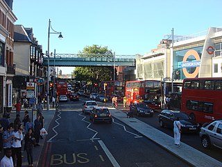
Brixton Road is a road in the London Borough of Lambeth, leading from the Oval at Kennington to Brixton, where it forms the high street and then forks into Effra Road and Brixton Hill at St Matthew's church at the junction with Acre Lane and Coldharbour Lane. Brixton Market is located in Electric Avenue near Brixton Underground station and in a network of covered arcades adjacent to the two railway viaducts. The market arcades were declared listed buildings in 2009 following controversial proposals by Lambeth Council to replace them with a large US-style mall. The former "Brixton Oval" is at the southern end with Lambeth Town Hall, the Ritzy Cinema, the Brixton Tate Library and St Matthew's church. The space was renamed Windrush Square in 2010, in honour of the area's early Caribbean migrants and the HMT Empire Windrush, which in 1948 brought 492 passengers from Jamaica to London.

<span class="mw-page-title-main">Brixton (UK Parliament constituency)</span> Parliamentary constituency in the United Kingdom, 1885–1974

Brixton was a parliamentary constituency centred on the Brixton district of South London. It returned one Member of Parliament (MP) to the House of Commons of the Parliament of the United Kingdom, elected by the first-past-the-post system.

<span class="mw-page-title-main">Lambeth London Borough Council</span> Local authority in Greater London, England

Lambeth London Borough Council is the local authority for the London Borough of Lambeth in Greater London, England. It is a London borough council, and one of the 32 in the United Kingdom capital of London. The council meets at Lambeth Town Hall in Brixton. Lambeth is divided into 25 wards: thirteen are represented by 3 councillors and twelve are represented by 2. The council was first elected in 1964.

<span class="mw-page-title-main">Lambeth Town Hall</span> Municipal building in London, England

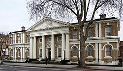
Lambeth Town Hall, also known as Brixton Town Hall, is a municipal building at the corner of Brixton Hill and Acre Lane, Brixton, London. The town hall, which is the headquarters of Lambeth London Borough Council, is a Grade II listed building.

<span class="mw-page-title-main">Chelsea Town Hall</span> Municipal building in London, England

Chelsea Town Hall is a municipal building in King's Road, Chelsea, London. The oldest part is a Grade II* listed building and the later part is Grade II listed.

<span class="mw-page-title-main">Council Buildings, Rushden</span> Municipal building in Rushden, Northamptonshire, England

The Council Buildings are based in Newton Road, Rushden, Northamptonshire, England. The structure, which was the headquarters of Rushden Urban District Council, is a locally listed building.

<span class="mw-page-title-main">Wednesbury Town Hall</span> Municipal building in Wednesbury, West Midlands, England

Wednesbury Town Hall is a municipal building in Holyhead Road in Wednesbury, West Midlands, England. The structure, which was the meeting place of Wednesbury Borough Council, now operates as an events venue.

<span class="mw-page-title-main">Toxteth Town Hall</span> Municipal building in Toxteth, Merseyside, England

Toxteth Town Hall, formerly known as Toxteth Park Public Offices, is a municipal building in High Park Street, Toxteth, Merseyside, England. The structure, which currently operates as a community centre, is a grade II listed building.

<span class="mw-page-title-main">Kettering Municipal Offices</span> Municipal building in Kettering, Northamptonshire, England

The Municipal Offices is a municipal building in Bowling Green Road in Kettering, Northamptonshire, England. The building accommodates the offices and meeting place of Kettering Town Council.

References

  1. 1 2 3 Historic England. "Old Town Hall (Church of England Children's Society), Kennington Road, SE11 (1080399)". National Heritage List for England . Retrieved 20 February 2022.
  2. 1 2 3 4 Sheppard, F. H. W. (1956). "'Kennington: Introduction and the demesne lands', in Survey of London: Volume 26, Lambeth: Southern Area". London: British History Online. pp. 18–31. Retrieved 20 February 2022.
  3. 1 2 3 4 "London's Town Halls". Historic England. p. 140. Retrieved 5 February 2022.
  4. Historic England. "Lambeth Town Hall (1080534)". National Heritage List for England . Retrieved 20 February 2022.
  5. Snow, Perry Allan (2000). Neither Waif Nor Stray The Search for a Stolen Identity. Univeral Publishers. p. 79. ISBN   978-1581127584.
  6. Children in Britain. British Information Services. 1962. p. 45.
  7. "Vauxhall, the Oval and Kennington" . Retrieved 20 February 2022.
  8. "Kennington ARP Post". BBC. Retrieved 20 February 2022.
  9. "The Waifs and Strays Story". Children's Homes. Retrieved 20 February 2022.
  10. "Children's Society sells £17m HQ that is 'outdated' and needs 'significant repair'". Civil Society. 15 January 2019. Retrieved 20 February 2022.
  11. Reuvid, Jonathan (2005). Doing Business in the Countryside: The Complete Guide to Rural Commerce. Logan Page. p. 273. ISBN   978-0749443894.
  12. "The Countryside Alliance Foundation" . Retrieved 20 February 2022.
  13. "Kennington Town Hall". Airflow Design Services. Retrieved 20 February 2022.
  14. "The Hall, Kennington Creative Hub". Desks Near Me. Retrieved 20 February 2022.